
NOTE: DUE TO THE IMPACTS OF THE 2025 DRAGON BRAVO FIRE, ACCESS TO THE NORTH RIM IS CLOSED UNTIL AT LEAST MAY 2026.
Note that many of the areas described below were impacted by the 2025 Dragon Bravo Fire. I will maintain the pre-fire photos below as documentation of the pre-fire conditions, but when I get the chance I will supplement them with post-fire photos too. As there is still no public access to the area, that has not been possible yet. The fire primarily impacted areas in the National Park to the east and northeast of the developed North Rim area and AZ-67, with the exception of the outer Walhalla Plateau. More than 50% of the developed area was destroyed, including the Grand Canyon Lodge and North Rim Visitor Center. The North Kaibab Trail was also impacted by the fire and is closed to public access until further notice.
6 million people travel to Northern Arizona every year to visit one of the grandest canyons in the world. 90% of them go to the South Rim. This makes sense in many ways. It’s the closest to major airports in Vegas, Phoenix and Flagstaff, for starters. It’s the closest to the main population centers of the region as well (again, Vegas and Phoenix). And it’s closest to Flagstaff, the largest city in either northern Arizona or southern Utah, and an attraction in itself.
But there is another side to the canyon, that far fewer people see, the North Rim. This side still echoes Theodore Roosevelt’s famous quote that hangs in the park headquarters to this day.
“In the Grand Canyon, Arizona has a natural wonder which is in kind absolutely unparalleled throughout the rest of the world. I want to ask you to keep this great wonder of nature as it now is. I hope you will not have a building of any kind, not a summer cottage, a hotel or anything else, to mar the wonderful grandeur, the sublimity, the great loneliness and beauty of the canyon. Leave it as it is. You cannot improve on it. The ages have been at work on it, and man can only mar it.”
Theodore Roosevelt
Now, you might ask, ”why would I want to go North when I can get to the South Rim faster?” Well, let’s take a look at why you might want to take a trip North and visit that area instead of heading South, especially if you are driving from the north or east (Utah or Page). Let’s start with the basics and we’ll expand from there.
We’ll look at the following areas
- the geology of the canyon (why is this a national park?);
- Where is the North Rim?
- When can you visit the North RIm?
- Points of Interest on the North Rim
- Hiking Opportunities on the North Rim
- Cycling opportunities on the North Rim
- The best time to visit the North Rim
- More adventurous options for viewpoints on the North Rim
- a sample itinerary for potential visitors
- Accommodation options on the North Rim
Grand Canyon Geology
Grand Canyon National Park is a geologist’s dream. The rock exposed in Grand Canyon stretches back 1.8 billion years and includes primarily alternating periods of ocean coverage and desert. From youngest to oldest, the layers are as follows:
Kaibab Limestone
The youngest of the currently existent layers in Grand Canyon; a resistant, cliff-forming layer that is known for its rich marine fossil deposits due to its marine origins when the area lay under the eastern Pacific Ocean.
Toroweap Formation
A thin, sloping layer, signifying additionally prone to erosion. Composed of gypsum & shale with additional sandstone. The Toroweap was deposited by a combination of shallow sea environments and coastal dunes.
Coconino Sandstone
Thick cliffs formed by the largest desert represented in any Canyon layer. The Coconino is one of the most difficult layers to hike through due to the grade of the trails required to traverse its steep, thick cliffs. Evidence of wind-blown sand can be seen and felt in the layer today.
Hermit Shale
A sloping formation that frequently has poorly preserved plant fossils. Dark red due to the iron present in the rock.
Supai Group
A distinctive red layer rich in iron, as is the Hermit Shale. The Supai Group contains a mixture of slopes and cliffs. It’s perhaps most famous for its occurrence in Sedona, including Oak Creek Canyon. Formed in an environment similar to the Gulf Coast today.
Redwall Limestone
A thick layer of exceptionally pure, cliff forming limestone. Though it appears red, the natural color is whitish grey. The red color comes from minerals in layers above, carried down by melting snow & rain and staining the surface. As with the Coconino Sandstone, this is one of the most difficult layers to hike through due to its thickness.
Muav Limestone
A whitish layer of cliff-forming limestones beneath the Redwall. Several of the most spectacular Canyon waterfalls, including Roaring Springs and Thunder River, originate in the Muav.
Bright Angel Shale
A greenish-tinted sloping layer beneath the two limestones. The distinctive green color comes from trilobite excrement; so many trilobites were present in the swampy landscape at the time that they managed to stain the entire layer.
Tapeats Sandstone
A thick sandstone layer representing another desert landscape. While archeological sites can be found throughout the Canyon, the Tapeats cliffs can often be a particularly good spot to encounter them.
Vishnu Basement Rocks
Zoroaster Granite
Pink granitic igneous intrusions into the Vishnu Schist. An example of the influence of Clarence Dutton on the naming of Grand Canyon sites – he named many features in the canyon after Hindu and Egyptian deities.
Vishnu Schist
The oldest rock in the central Canyon, though not the oldest in the entire Canyon (that honor goes to the Elves Chasm gneiss). The Schist is an exceptionally erosion-resistant layer that currently represents the bottom of the canyon. Due to a combination of its resistance to erosion, a reduction in flow, and the impacts that Glen Canyon Dam has had on the Colorado River, the Canyon only deepens by about the thickness of a sheet of paper each year today.
The horizontally deposited layers were uplifted unusually regularly to form the Colorado Plateau, after which point, following the rise of the Rocky Mountains, the Colorado River began cutting through the rock to form the canyon. Using the strength of seasonal floods carrying boulders the size of cars and the continuous action of sediment suspended in the water wearing away at the riverbed and cutting down, the river cut into the plateau to form the main canyon, while the same process occurred on smaller scales on both rims, typically along fault lines, to form tributary canyons and the landscape we see today.
The North Rim, being higher, gets more snow and rain, and therefore has experienced more erosion and contributes more to the width of the canyon than the South Rim does. While the canyon’s depth is increasing only marginally today, the processes expanding it’s width are unaffected and continue to widen the canyon today.

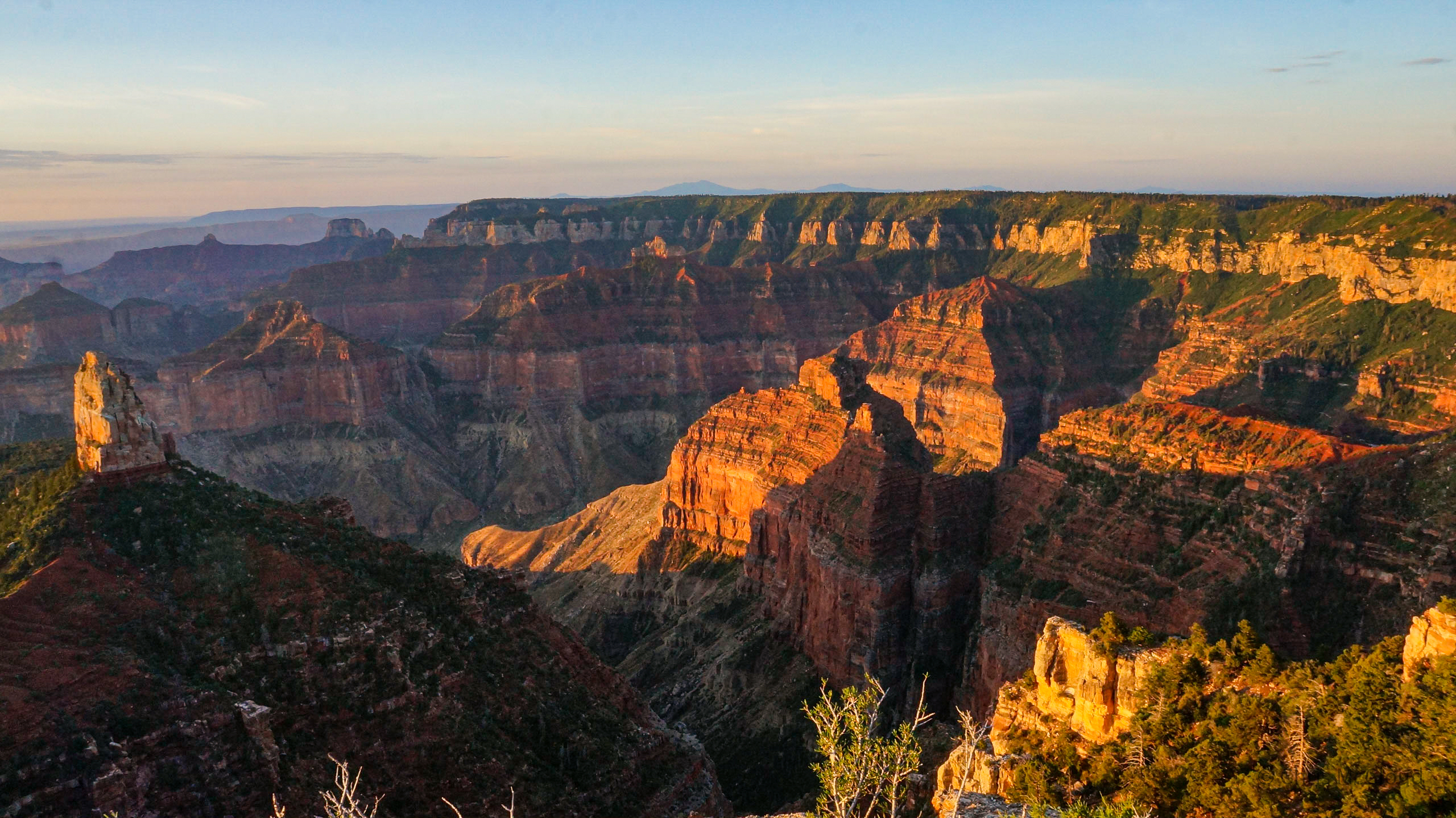
Grand Canyon National Park

North Rim
Grand Canyon National Park
Where Is the North Rim?
The North Rim is, as the name implies, the northern boundary of the Grand Canyon. It sits on the Kaibab Plateau, about 1000 feet above the South Rim. This elevation difference creates an entirely different climate zone on the North Rim. While the South Rim is high desert, the North Rim is a dense ponderosa forest mixed with aspens, especially in burn areas. The North side is significantly cooler and wetter than the South, both in rain and snow.
Perhaps crucially, since twice as much precipitation falls on the North Rim as the South each year due to its higher elevation, the erosional features that people often associate with Grand Canyon are primarily located on the North side. Consequently, seeing the north side affords not just a longer view, but a closer view into the processes that created and continue to develop the canyon to this day.
The North Rim is about 4 hours from the South Rim by car, since there is no crossing of the Colorado River between Lee’s Ferry/Marble Canyon and Las Vegas. It’s about 6.5 hours from Vegas and 5 from Flagstaff. It’s also about 2 hours from Zion National Park and 3 from Bryce Canyon National Park.
- TIME WARNING
- Remember that Utah (and the Navajo Nation, which is primarily within Arizona) and Arizona are in different time zones in the summer and you will need to add an hour
- In winter, you will need to add the hour coming from Las Vegas, whereas Utah and Arizona will be in the same time zone.
When Can I Go?
The North Rim can’t be visited by vehicle year round. The State of Arizona only maintains the road leading to it from May to November each year. The final 6 weeks of this period are day-use only, as overnight facilities in the park open May 15 and close October 15 annually. You may hear some people say – incorrectly – that the North Rim closes October 15, but this is not the case, that is only when the overnight facilities close. You can still drive AZ-67 into the park until the state closes the road for the winter. Typically this occurs 12/1 at 8 AM. It can occur earlier if weather dictates that; usually the week prior is the most risky for early closures.
Best Sunrise/Sunset Points
I lead with this because this is the most popular question for many Grand Canyon visitors. This is a deceptively challenging question, and the honest answer is whichever you are closest to. If you are running behind, don’t risk missing out entirely because you were trying to make it to a point farther away than you can reach within 30 minutes of sunset.
That said, there are three points that are not just the best on the North Rim to be reachable by paved road, but the best reachable in the park on such roads.
- Sunset: Cape Royal
- Sunrise: Cape Final, Point Imperial, Cape Royal


Point Imperial
Grand Canyon National Park, North Rim

North Rim
Grand Canyon National Park
North Rim Points of Interest
By far the best view of the canyon that you can drive to on a paved road is located on the North Rim, Cape Royal. It’s a several hour drive out from the developed North Rim area near Bright Angel Point. Cape Royal is also the best sunset point in the park that you can drive to on a paved road. Near it are Point Imperial, an east facing view good for sunrise, and Cape Final, a 2.5 mile sunrise view hike accessible from Cape Royal Road. Walhalla Pueblo, a Native American archeological site, is also located just off Cape Royal Road on the Walhalla Plateau. Grand Canyon Lodge formerly sat at Bright Angel Point and had a magnificent sun room view of the canyon, porch chairs overlooking the canyon during good weather, and a Brighty statue whose nose has been rubbed shiny over the years for luck. Unfortunately, the lodge was destroyed by the Dragon Bravo Fire in mid July 2025.

North Rim
Grand Canyon National Park


North Rim
Grand Canyon National Park

Cape Royal, North Rim
Grand Canyon National Park


North Rim
Grand Canyon National Park
Hiking Opportunities
The North Rim offers more on-rim hiking opportunities than the South Rim, such as the Widforss Trail, Ken Patrick Trail, Uncle Jim Trail, Cliff Spring Trail, and Cape Final Trail. I intend to do the Widforss Trail this fall. Cliff Spring offers great wildflowers and is just off the Cape Royal Road. It does require dropping into the canyon and may be slightly overgrown. Cape Final is fantastic for eastern views for sunrise! You can get a backcountry permit to camp out here to see it in person. The Ken Patrick Trail offers the chance to hike from Point Imperial to the Grand Canyon Lodge. A spur off of it, the Uncle Jim Trail, leads to Uncle Jim Point dividing Roaring Springs Canyon and Bright Angel Canyon and offering one of the few views to the South Rim Village in the park on the North Rim west of Cape Royal.


North Rim
Grand Canyon National Park

Uncle Jim Point, North Rim
Grand Canyon National Park
- For more on the North Kaibab Trail, check my details from the Arizona Trail:
- North Rim-Roaring Springs (day hike opportunities)
- Roaring Springs-Ribbon Falls
Biking Opportunities
The portion of the Arizona Trail north of AZ-67 within the park is accessible to bikers, as are all paved roads. The ride out to Cape Royal is magnificent. Stop at Walhalla Pueblo and do the detour to Point Imperial. Bring layers, especially in summer, and be mentally prepared for severe weather in summer, especially from afternoon through evening. Outside of the park, in the National Forest, lies the Rainbow Rim Trail for mountain bikes.
Best Time to Visit
Always the million dollar question, no? But I recommend the last week of September through the first two of October. This is when the aspens peak. The combination of fall color and the canyon itself is absolutely spectacular. Words don’t do it justice, so I’ll show some pictures instead:


North Rim
Grand Canyon National Park
Grand Canyon North Rim Itinerary
- If you are approaching the park from the west (e.g. Zion National Park), stop in Kanab, Utah, on the way. Separate post to come on Kanab, but it has one of the best food scenes in the area, with Big Al’s at the Junction offering great bison burgers and shakes, and Kanab Creek Bakery being a great brunch option. Follow up a Kanab stop with one at Pipe Spring National Monument near Fredonia, Arizona.
- If you are approaching from the east, a must stop is Lee’s Ferry, where you can actually drive to the Colorado River. Get a picture with a Grand Canyon National Park entrance sign and hope that the Paria River is flowing, which will produce an interesting effect. The brown Paria will flow side-by-side with the green/blue Colorado (color is impacted by sediment trapped by Grand Canyon Dam) for maybe 100 yards before mixing together, when it flows. If you can, hike up Paria Canyon a ways (even spend a night, or backpack!) through Vermillion Cliffs National Monument. Or just enjoy the drive along the Vermilion Cliffs, especially scenic at sunset.
- You can learn more about Paria Canyon here:
- https://aspenstracks.com/azt-approach-day-1-lees-ferry-and-entering-paria-canyon/
- https://aspenstracks.com/azt-approach-day-2-paria-canyon-vermilion-cliffs-wilderness-vermilion-cliffs-national-monument/
- https://aspenstracks.com/azt-approach-day-3-paria-canyon-vermilion-cliffs-wilderness-vermilion-cliffs-national-monument/
- https://aspenstracks.com/day-6-paria-canyon-buckskin-gulch/
- https://aspenstracks.com/day-7-buckskin-gulch/
- https://aspenstracks.com/day-8-part-1-buckskin-gulch-to-the-arizona-trail/
- You can learn more about Paria Canyon here:
- Both approaches merge in Jacob Lake. Jacob Lake Inn is not only an accomodation option, it’s an iconic food stop. Jacob Lake cookies are LEGENDARY. When I worked at Grand Canyon, it was expected that any trip to the North Rim would involve bringing these cookies back to the South Rim for the rest of the staff.
- From here, AZ-67 leads south through aspen groves, ponderosa pines and meadows to the North Rim gate. Keep your eyes peeled for the local bison herd (nonnative) based in House Rock Valley. The herd got its start when a local cattle businessman attempted to crossbreed bison with cattle to create a form of “superlivestock” and relocated them to the North Rim. They are now wild and owned by the State of Arizona. Watch also for rarer native species like the Kaibab squirrel, identifiable through its tufted ears. In the fall, the aspens will light this drive up. In the summer, wildflowers bloom in meadows that haven’t been impacted by the nonnative bison herd.
- If it’s fall or the wildflowers are blooming, think about taking a stroll on the Arizona Trail that parallels AZ-67. In fall it feels like walking through a tunnel of gold. Check out this portion of my hike on the AZT for ideas and send me a message on Twitter or Facebook if you’d like help picking a stretch:
- https://aspenstracks.com/day-10-arizona-trail-kaibab-plateau-north-to-jacob-lake/
- https://aspenstracks.com/arizona-trail-day-4-jacob-lake-to-fr205b/
- https://aspenstracks.com/arizona-trail-day-4-part-2/
- https://aspenstracks.com/arizona-trail-day-4-part-3/
- https://aspenstracks.com/arizona-trail-day-5-part-1/
- https://aspenstracks.com/arizona-trail-day-5-part-ii/
- https://aspenstracks.com/arizona-trail-day-5-part-3/
- https://aspenstracks.com/arizona-trail-day-5-part-3-2/
- https://aspenstracks.com/arizona-trail-day-6-part-1/
- https://aspenstracks.com/arizona-trail-day-6-part-2/
- https://aspenstracks.com/arizona-trail-day-7-part-1/
- https://aspenstracks.com/arizona-trail-day-7-part-2-grand-canyon-north-rim/
- https://aspenstracks.com/amazing-stunning-arizona-trail-day-14-part-2-grand-canyon-np-border-lindbergh-hill/
- If it’s fall or the wildflowers are blooming, think about taking a stroll on the Arizona Trail that parallels AZ-67. In fall it feels like walking through a tunnel of gold. Check out this portion of my hike on the AZT for ideas and send me a message on Twitter or Facebook if you’d like help picking a stretch:
- Eventually you will come to the North Rim entrance gate, and proceed through Thompson Canyon to the junction with Cape Royal Road. From here, you have two options that I would differentiate by time of day.
- Option 1
- If you are within 2 hours of sunset, head direct to Cape Royal and save the rest for another day.
- Option 2
- Head to the lodge if you feel like eating first or have had a long drive and want to stretch your legs. Walk the Transcept Trail or head out to Bright Angel Point, and grab a beer to sit out on the patio
- Drive out to Cape Royal for sunset, stopping at Point Imperial on the way. Stop at the Walhalla Pueblo en route for some cultural history, Roosevelt Point and Angel’s Window, an arch in the upper layers of the Kaibab Plateau.
- Day 2
- Start the day with sunrise at Cape Final, Cape Royal, or Point Imperial. Follow that up with a hike out to Widforss Point (this could be worked into Option 1 above if you arrive early enough) and/or down the North Kaibab Trail. The trailhead for the North Kaibab fills early, so be prepared to walk from the main lodge area on the Bridle Trail if you opt for sunrise as recommended. It fills particularly early in high summer as people attempt to beat the heat in the inner canyon. It is not recommended to hike very far into the Inner Canyon between 10-4 between June and August. The trail is steep and even just going to Roaring Springs is a good 1/2-3/4 day hike by itself. The trail gets significantly steeper after Supai Tunnel (where water should be available) so many people choose there or the slightly higher Coconino Overlook as the turnaround point. For a day hike I would not recommend going beyond Roaring Springs at the absolute farthest for most.

North Rim
Grand Canyon National Park

Cape Royal, North Rim
Grand Canyon National Park

Cape Royal, North Rim
Grand Canyon National Park

Cape Royal, North Rim
Grand Canyon National Park

North Rim
Grand Canyon National Park

North Rim
Grand Canyon National Park
More Adventurous Options
If you have the vehicle, you can take the drive out to Point Sublime from several points along the North Rim. It’s recommended to approach from the north (from the Kaibab National Forest) rather than from the east (the North Rim visitor complex itself) since the road is in better shape from the North. Pick up a Motor Vehicle Use Map from the Kaibab National Forest visitor center in Jacob Lake, Arizona.
North Rim Accommodations
The North Rim is pretty remote, offering fewer accommodation options than the South. The North Rim Campground in the park was relatively spared by the 2025 Dragon Bravo Fire and should be an option in the future as well as several campgrounds in the Kaibab National Forest. With the destruction of the Grand Canyon Lodge, currently the only lodging is Kaibab Lodge just outside the park border in the National Forest. At the junction of AZ-67 and US-89A sits the previously mentioned Jacob Lake Inn as well. From there, it’s Fredonia, Kanab, or Page.
North Rim Campground: https://www.nps.gov/grca/planyourvisit/cg-nr.htm
Kaibab Lodge: HTTPS://www.kaibablodge.com
Jacob Lake Inn: HTTPS://www.Jacoblake.com
Feel free to rearrange things noted above, but hopefully it gives you some ideas about what to do on the spectacular North Rim! Also, always make sure to check the park website for updated conditions, especially during fire season and the monsoon!
Official Park Website: nps.gov/grca

North Rim
Grand Canyon National Park

North Rim
Grand Canyon National Park

North Rim
Grand Canyon National Park

North Rim
Grand Canyon National Park


North Rim
Grand Canyon National Park

North Rim
Grand Canyon National Park


Grand Canyon National Park


North RIm
Grand Canyon National Park

North Rim
Grand Canyon National Park

North Rim
Grand Canyon National Park

North Rim
Grand Canyon National Park


North Rim
Grand Canyon National Park

Point Sublime, North Rim
Grand Canyon National Park

Point Sublime, North Rim
Grand Canyon National Park


Point Sublime, North Rim
Grand Canyon National Park
Lenore
Wow! Spectacular descriptions and photos and hikes. That’s some serious information to a hobby hiker! Lol. Watching your vermillion video made me think of Forrest Gump. Run Forrest run! Sheesh you traveled far. Thanks for all this. Really awesome 👏😄