Visited National Park #234
The Basics: Established in 2016 by Presidential Proclamation under the Antiquities Act in Millinocket, Maine, Katahdin Woods & Waters National Monument, one of three national parks in Maine, preserves the remote North Woods landscape surrounding Baxter State Park and Maine’s highest mountain, the nearly mile-high Mt Katahdin. It was donated by the founder of Burt’s Bees and accepted by the NPS. Mountain views, forested woodlands, marshes and waterfalls are all prominent in the monument. It’s one of the 425 national parks managed by the National Park Service.

Katahdin Woods & Waters National Monument
Millinocket, Maine
Things to Know for Your Visit to Katahdin Woods & Waters
This remote national park is in many ways the legacy product of efforts to create a national park in the remote and wild North Woods of Maine. It adjoins Baxter State Park on the east and protects the woods, streams, waterfalls, and views of the famous Mt Katahdin, Maine’s highest summit.
My Visit to Katahdin Woods & Waters
I’m back in New England for a week and a half or so, taking the opportunity to see some friends, spend a week at Baxter State Park, and also wrap up the final three eastern Massachusetts & Maine national parks I haven’t made it to yet: Longfellow House-Washington’s Headquarters, Katahdin Woods and Waters (Maine), and Salem Maritime National Historic Site.
OK, technically I have been on the grounds of the Longfellow House previously, but I didn’t count it because I wasn’t able to get on a tour of the house. And technically I’ve been to Salem Maritime, probably to not have gotten there given my history with Newburyport would have been a surprise, but didn’t feel that it was focused enough on the park to count it, either. This time, any hesitation will be erased.
After my visit to Longfellow House and several days at Baxter, it’s Katahdin’s turn.
The Loop Road
My college roommate and I pile into his car on a free day at Baxter and drive over to Katahdin Woods and Waters. Entering from Stacyville, we proceed across the East Branch of the Penobscot River and into the main body of the monument. Unlike yesterday’s pouring rain, today we have a glorious blue sky day with just enough clouds to add another dimension to the experience. The mountain is still obscured in the clouds as we enter the monument, but hope springs with the cloud forecast I checked before coming and the blue skies overhead.

Katahdin Woods & Waters National Monument
Millinocket, Maine

Katahdin Woods & Waters National Monument
Millinocket, Maine
We decide to drive clockwise around the loop, starting with the Katahdin views to the south, and then wrapping up with a hike or two in the north before continuing on to the north side of Baxter in the afternoon. We are still hoping to see a moose, so our first stop was Lynx Pond, a wonderful Maine glacial pond view, but alas, no moose. Fireweed bloom in the area was coming along nicely, though – one of the better blooms I’ve seen south of Alaska.

Katahdin Woods & Waters National Monument
Millinocket, Maine

Katahdin Woods & Waters National Monument
Millinocket, Maine
Katahdin Viewpoints
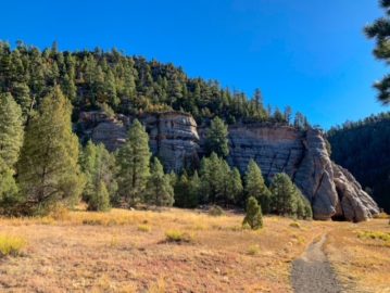
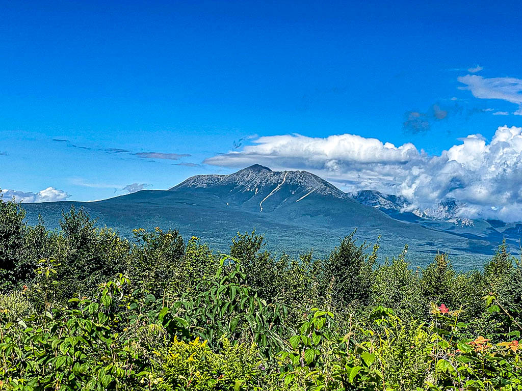
Continuing along the loop road, we reach the southwest portion, where the views of Katahdin take center stage. There are around 5 spectacular views of the mountain, and this is the clearest day we’ve had to see it all week. My personal favorites were the southernmost, the separate Katahdin Overlook, and one of the northern ones. There was also a great moment when the road was running at the mountain and it was framed magnificently by the trees.

Katahdin Woods & Waters National Monument
Millinocket, Maine

Katahdin Woods & Waters National Monument
Millinocket, Maine

Katahdin Woods & Waters National Monument
Millinocket, Maine

Katahdin Woods & Waters National Monument
Millinocket, Maine


Katahdin Woods & Waters National Monument
Millinocket, Maine
Barnard Mountain
As we head north along the loop, we decide to stretch our legs on Barnard Mountain. We join the International Appalachian Trail for part of the way and follow a series of closed roads to the turnoff to the summit. A prominent point rising above the surrounding foothills, Barnard Mountain is a moderate several miles winding through the forest and, at one point, between several boulders, to reach the summit and its overlook of Katahdin Lake – where we just were yesterday, paddling in the rain – and the Katahdin massif rising behind. Still no moose, but the trail is worth the time.

Katahdin Woods & Waters National Monument
Millinocket, Maine

Katahdin Woods & Waters National Monument
Millinocket, Maine
Exit
From Barnard, we have to make a choice, and unfortunately decide that unless we proceed to the northern portion of Baxter, we won’t make it to our spots there before dark. Unfortunately, that means bypassing Olin Falls, at least for now. It goes on the list for my spots to stop on the IAT. And with that, we head back to Baxter, feeling that we could not have picked a better day yet this week for our visit to Katahdin Woods & Waters.
Things to Do
- Katahdin Loop Road scenic drive
- Views of Katahdin and surrounding Baxter State Park
- Hiking
- Cycling
- Waterfalls and mountain peaks to hike to
- Hunting (east of East Fork Penobscot River only)
Suggested Itinerary
Enter via Swift Brook Rd from Stacyville, Maine. The road will turn to gravel and pass through a discontiguous section of the monument east of the East Branch Penobscot River, then cross the river around Whetstone Falls. Shortly after crossing the river, the area south of the road is in the monument, while the north is private for several miles. Just shy of the Deasey Pond Trailhead, the road fully enters the monument and there is the most noticeable entrance sign. This is Mile 0 of the Katahdin Loop Road. The first view of Katahdin is at Mile 1 past this location, and the loop itself begins 1-2 miles later. Turning left on the road, Lynx Pond offers a nice Maine pond stroll with moose possibilities after a half mile or so. Around mile 6-7 is the spur to the Katahdin Overlook, the first major viewpoint and well worth the short spur. Katahdin views will continue to be the highlight of the southwest portion of the loop. There are several good trailheads worth checking out on the northern portion of the loop; among them, Barnard Mountain (shared in part with the International Appalachian Trail) and Orin Falls on Wassataquoik Stream, which is a substantial feature of neighboring Baxter State Park as well. Backpacking options are extensive along the IAT in the northern portion of the park.
Nearby Parks and other Federal and State Lands
Baxter State Park
A crown jewel state park on a national scale, Baxter State Park protects the massif of mile-high Mt Katahdin, one of New England’s highest summits, and its surrounding landscapes. The park is the product of the efforts of former governor Percival Baxter, who purchased the tracts now contained within it one by one and donated them to the people of Maine. In addition to Maine’s highest summit, Katahdin’s Baxter Peak, the park contains two other Maine 4000 foot peaks, North Brother and Katahdin’s Hamlin Peak. Several other summits, such as South Brother and The Traveler, are on the New England Hundred Highest lists. It also contains a large moose population and is one of the best wildlife parks in the east. It is Maine’s largest wilderness, much being managed along similar principles as federal wilderness, and is the northern terminus of the Appalachian National Scenic Trail.
Saint Croix Island International Historic Site
On the border of New Brunswick and Maine, in the middle of the St Croix River, St Croix Island commemorates the Pierre Dugua French expedition, which spent the winter of 1604-1605 on the island. 35 of 79 men died, trapped by freezing temperatures and with little access to food and water. The settlement attempt, the beginning of permanent European presence in North America, was short lived but important. There is a US NPS site on the south bank of the river and a Parks Canada interpretive site on the New Brunswick side, hence the IHS name of the site. The island itself today is in the US and part of the NPS park. Due to its small size and concentrated significance, access to the island itself is not permitted, but the shoreline sites interpret the significance and good views of the island are available.
Appalachian National Scenic Trail
The Appalachian Trail, the dream of many thruhikers. The name evokes images of a trail through dense forests and across mountain ridgelines above treeline for many, along with its iconic white blaze, adopted from its inspiration, Vermont’s Long Trail. The “AT” begins its journey for many at Springer Mountain in Georgia and travels nearly 2200 miles north along the spine of the Appalachian Mountains to its conclusion on Baxter Peak at Katahdin. Its extension, the International Appalachian Trail, passes through Katahdin Woods and Waters en route to New Brunswick and the Canadian portion of the Appalachian uplift.
Farther away, you can find Acadia National Park, the White Mountain National Forest (NH), Acadia National Park, the Allagash Wilderness Waterway, West Quoddy Head State Park, as well as several other national wildlife refuges and state parks.