Skip to content
Aspen's Tracks
Menu
Backpacking
thruhiking
The Arizona Trail
To Thruhike or Section Hike, That is the Question
Thruhiking The Amazing Arizona Trail
Trail Entries & Logistics
Northern Arizona (Utah-Pine)
Passage 43: Buckskin Mountain
Amazing, Spectacular Arizona Trail: Northern Trailhead-Buckskin Mountain Camp (Day 1)
Amazing, Spectacular Arizona Trail Thruhike: Buckskin Mt-Kaibab Plateau North
Passage 42: Kaibab Plateau North
Amazing, Spectacular Arizona Trail Thruhike: Kaibab North-Jacob Lake
Passage 41: Kaibab Plateau Central
Amazing, Spectacular Arizona Trail Thruhike, Day 4: Jacob Lake-FR 205B
Amazing, Spectacular Arizona Trail Thruhiking: FR 205B-MM 37.2
Amazing, Spectacular Arizona Trail, Day 4: MM 37.2-MM 39
The Amazing, Spectacular Arizona Trail: MM 39-Telephone Hill
Passage 40: Kaibab Plateau South
Amazing, Spectacular Arizona Trail, Day 5: Telephone Hill-Little Round Valley
Amazing, Spectacular Arizona Trail Thruhike: Little Round-Pleasant Valleys
Amazing, Spectacular Arizona Trail: Pleasant Valley-Upper Tater Canyon
Amazing, Spectacular Arizona Trail Thruhike: East Rim Overlook-≈MM 61.2
Amazing, Spectacular Arizona Trail, Day 6: Upper Tater Canyon-East Rim Overlook
Passage 39: Grand Canyon North Rim
Amazing, Stunning Arizona Trail: Lindbergh Hill-North Rim
Passage 38: Grand Canyon
Amazing, Stunning Arizona Trail Thruhike: Grand Canyon North Rim-Roaring Springs
Backpacking the Amazing Arizona Trail: North Kaibab Trail, Roaring Springs to Ribbon Falls (Day 8 – Passage 38, Grand Canyon Inner Canyon)
Thruhiking Amazing, Stunning Arizona Trail: Ribbon Falls-Bright Angel Campground
Amazing, Spectacular Arizona Trail – Bright Angel CG (Colorado River)-South Rim
Passage 37: Grand Canyon South Rim
Amazing, Spectacular Arizona Trail: Triple Zero on the South Rim-Tusayan East
Amazing, Spectacular Arizona Trail Thruhike: Tusayan East to Grandview West
Passage 36: Coconino Rim
Amazing, Spectacular Arizona Trail: Coconino Rim to Moqui Stage Station
Passage 35: Babbitt Ranch
Amazing, Spectacular Arizona Trail Thruhike: Moqui Stage Station-Babbitt Ranch Campsite
Amazing, Spectacular Arizona Trail: Babbitt Ranch Campsite-Missouri Bill Hill
Passage 34: San Francisco Peaks
Amazing, Spectacular Arizona Trail: Missouri Bill Hill-San Francisco Peaks
Amazing, Spectacular Arizona Trail Thruhike: San Francisco Peaks, Part 1
Amazing, Spectacular Arizona Trail, Day 21: Heart of the San Francisco Peaks
Amazing, Spectacular Arizona Trail: Heart of the San Francisco Peaks, Part 3
Passage 33: Flagstaff
Amazing, Spectacular Arizona Trail Thruhike: Schultz Pass West
Amazing, Spectacular Arizona Trail Thruhike: Dry Lake Hills-Flagstaff
Amazing, Spectacular Arizona Trail: Schultz Pass-Dry Lake Hills
Amazing, Spectacular Arizona Trail: Flagstaff Zero
Passage 32: Elden Mountain
Amazing, Spectacular Arizona Trail Backpacking: Schultz Pass East
Amazing, Spectacular Arizona Trail: US 89-Picture Canyon (Passage 32)
Amazing, Spectacular Arizona Trail: Picture Canyon-Walnut Canyon
Passage 31: Walnut Canyon
Arizona Trail, Day 26: Walnut Canyon National Monument, Part I
Arizona Trail, Day 26: Walnut Canyon National Monument, Part II
Arizona Trail, Day 26: Walnut Canyon National Monument, Part 3
Arizona Trail, Day 26: Walnut Canyon National Monument, Part 4
Thruhiking the Amazing, Beautiful Arizona Trail: Walnut Canyon, Part 2
Arizona Trail Thruhike, Day 27 – Passages 31 (Walnut Canyon) and 33 (Flagstaff South)
Discover Flagstaff – Where to Eat, Stay, Resupply, and Just Have a Good Time in Arizona’s Coolest Mountain Town
Passage 30: Anderson Mesa
Backpacking the Arizona Trail, Day 29 – Flagstaff to Anderson Mesa (Passages 31 & 33, Flagstaff & Walnut Canyon)
Arizona Trail, Day 30 – Anderson Mesa (Passages 31 and 30, Walnut Canyon and Mormon Lake)
Arizona Trail, Day 31 – Anderson Mesa to Double Springs (Passages 30, Anderson Mesa & 29, Mormon Lake)
Backpacking the Arizona Trail – Double Springs to Mormon Lake (Day 32; Passage 30, Mormon Lake)
Passage 29: Mormon Lake
Arizona Trail, Day 33 – Mormon Lake Zero
Backpacking the Arizona Trail – Mormon Lake to Shuff Tank (Day 34; Passages 29 & 28, Mormon Lake & Happy Jack)
Passage 28: Happy Jack
Backpacking the Amazing Arizona Trail, Day 35 – Passage 29 (Happy Jack)
Arizona Trail, Day 36 – Passage 29 (Happy Jack)
Passage 27: Blue Ridge
Backpacking the Arizona Trail, Day 38 – Blue Ridge Ranger Station to Mogollon Rim (Passage 28, Blue Ridge)
Backpacking the Arizona Trail – Clear Creek to Mogollon Rim (Passage 28, Blue Ridge)
Passage 26: Highline
Backpacking the Arizona Trail – Mogollon Rim to Highline Trail (Passage 27, Highline)
Backpacking the Arizona Trail – Highline Trail, Part I (Passage 27, Highline)
Backpacking the Arizona Trail – Highline Trail, Part II (Passage 27, Highline)
Backpacking the Arizona Trail, Day 40-41 – Highline Trail (Passage 27, Highline)
Backpacking the Arizona Trail, Day 41, Part III – Highline Trail (Passage 27, Highline)
Towns of the Arizona Trail and Roads: Friendly Pine
Central Arizona (Pine-Oracle)
Passage 25: Whiterock Mesa
Backpacking the Arizona Trail – Pine to Pine Ridge (Passage 25, Whiterock Mesa)
Backpacking the Arizona Trail – Pine Ridge to FR 194 (Passage 26, Whiterock Mesa)
Backpacking the Arizona Trail – FR 194 to Pine Spring (Passage 45, Whiterock Mesa)
Amazing, Spectacular Arizona Trail Thruhiking: Polk Spring – Red Hills
Passage 24: Red Hills
Backpacking the Arizona Trail, Day 46 – Red Hills (Passage 24)
Amazing, Spectacular Arizona Trail Thruhiking: Red Hills Ridge-The Park
Passage 23: Mazatzal Divide
Amazing, Spectacular Arizona Trail Thruhike: The Park-Horse Camp Seep
Amazing Arizona Trail Thruhiking: Spectacular Horse Camp Seep-Barnhardt Junction
Backpacking the Amazing Arizona Trail, Day 52 – Passage 23 (Mazatzal Divide, Part III)
Backpacking the Amazing Arizona Trail – Mazatzal Divide, Part IV (Day 52, Passage 23)
Passage 22: Saddle Mountain
Backpacking the Amazing Arizona Trail – Mazatzal Divide, Part V (Day 53, Passage 23)
Passage 21: Pine Mountain
Backpacking the Amazing Arizona Trail – Saddle Mountain, Part I (Day 53, Passage 23)
Backpacking the Amazing Arizona Trail – Saddle Mountain, Part II (Day 54, Passages 22 & 21)
Backpacking the Amazing Arizona Trail – Pine Mountain (Passage 21), Boulder Creek Trail
Backpacking the Amazing Arizona Trail – Pine Mountain (Passage 21), FR 422 to Pigeon Spring Trailhead
Passage 20: Four Peaks
Backpacking the Amazing Arizona Trail – Four Peaks North (Passage 20)
Backpacking the Amazing Arizona Trail – Four Peaks South (Passage 20)
Arizona Trail Backpacking Logistics – AZT Gateway Communities: Tonto Basin
Passage 19: Superstition Wilderness
Backpacking the Amazing Arizona Trail – Inspiration Point to Roosevelt Cemetery (Passages 20 & 19, Four Peaks to Superstition Mountains)
Backpacking the Amazing Arizona Trail – Cottonwood Creek (Passage 19, Superstition Wilderness)
Amazing Arizona Trail: Cottonwood Creek to Beautiful Pine Creek
Amazing, Spectacular Arizona Trail: Pine Creek-Rogers Trough
Passage 18: Reavis Canyon
Amazing, Spectacular Arizona Trail: Reavis Canyon-Alamo Canyon North (Day 63)
Passage 17: Alamo Canyon
Amazing, Spectacular Arizona Trail: Reavis Canyon-Alamo Canyon North (Day 63)
Amazing, Spectacular Arizona Trail Thruhike: Alamo Canyon South (Day 64)
Passage 16: Gila River Canyons
Amazing, Spectacular Arizona Trail, Day 64: Tonto NF Boundary-Martinez Canyon
Amazing, Spectacular Arizona Trail, Day 64: Martinez Canyon-Gila River
Amazing, Spectacular Arizona Trail Thruhiking: Gila River West (Day 65)
Amazing, Spectacular Arizona Trail, Day 66: Gila River East
Resupply Towns
Discover Flagstaff – Where to Eat, Stay, Resupply, and Just Have a Good Time in Arizona’s Coolest Mountain Town
Towns of the Arizona Trail and Roads: Friendly Pine
Arizona Trail Backpacking Logistics – AZT Gateway Communities: Tonto Basin
Kearny, Arizona: Towns of the Amazing Arizona Trail
Amazing Arizona Trail: An Extra (45) Miles from Glen Canyon
Thruhiking Amazing Vermilion Cliffs – Lee’s Ferry & Lower Paria Canyon
Backpacking Amazing, Beautiful Paría Canyon-Vermilion Cliffs Wilderness, Day 2
Spectacular Paria Canyon-Vermilion Cliffs Wilderness: Amazing Arizona Backpacking, Day 3
Beautiful, Spectacular Paría Canyon-Vermilion Cliffs Wilderness
Backpacking Beautiful Paría Canyon: Spectacular Big Springs-Upper Paria (Day 5)
Backpacking Beautiful Buckskin Gulch at Spectacular Vermilion Cliffs (Day 7)
Backpacking Paria Canyon-Vermilion Cliffs Wilderness – Buckskin Gulch to the Arizona Trail (AZT Approach Day 8, Part 1)
Backpacking Paria Canyon-Vermilion Cliffs Wilderness – Buckskin Gulch to the Arizona Trail (AZT Approach Day 8, Part 2)
Arizona Trail Approach, Day 8 (Part III) – Buckskin Gulch to AZT
Road Trips
Newburyport, MA: Best Towns in the US for Roadtrips
Discover Flagstaff – Where to Eat, Stay, Resupply, and Just Have a Good Time in Arizona’s Coolest Mountain Town
St. George, Utah: Best Towns of the Roads and Trails
National Parks
Is One National Park Service Designation Better than Another?
Everything You Need to Know About the America the Beautiful Federal Lands Pass
Grand Canyon National Park
Inner Canyon
Beautiful Grand Canyon: Spectacular Little Colorado/Colorado Rivers Confluence: Days 1-2
Beautiful Grand Canyon: Spectacular Little Colorado/Colorado Rivers Confluence: Day 3, Part 1
Amazing, Stunning Arizona Trail Thruhike: Grand Canyon North Rim-Roaring Springs
Amazing, Spectacular Arizona Trail: Grand Canyon, Roaring Springs-Ribbon Falls
Thruhiking Amazing, Stunning Arizona Trail: Ribbon Falls-Bright Angel Campground
Amazing, Spectacular Arizona Trail – Bright Angel CG (Colorado River)-South Rim
Beautiful Grand Canyon ‘s Iconic South Rim (Park Ranger Planning)
Spectacular North Rim of Beautiful Grand Canyon NP (Park Planner)
Amazing, Stunning Arizona Trail: Grand Canyon NP Border-Lindbergh Hill
Amazing, Stunning Arizona Trail: Lindbergh Hill-North Rim
Beautiful Katahdin Woods & Waters NM: Spectacular Mountain Views
Great Basin National Park: Spectacular Alpine and Cave Gem
Death along Beautiful Wilson’s Creek: National Park Planner
Remarkable, Stunning El Morro National Monument
Beautiful Walnut Canyon NM: Sinagua Cliff Dwelling History
Beautiful, Spectacular Castle Mountains National Monument
Spectacular Cedar Breaks National Monument’s Beautiful Winter Landscape
Chickasaw NRA: Beautiful Springs, Indigenous and CCC Heritage in Oklahoma
State Parks
Arizona State Parks
Utah State Parks
Maine State Parks
Baxter State Park
wilderness
Wilderness: What is It’s Beautiful, Spectacular Meaning to You?
Fossil Springs Wilderness
Fossil Springs Wilderness – Fossil Springs Trail
Fossil Springs Wilderness – Flume Trail
Fossil Springs Wilderness – Waterfall Trail
Fossil Springs Wilderness – FR 708
Four Peaks Wilderness
Backpacking the Amazing Arizona Trail – Four Peaks North (Passage 20)
Backpacking the Amazing Arizona Trail – Four Peaks South (Passage 20)
Backpacking the Amazing Arizona Trail – Inspiration Point to Roosevelt Cemetery (Passages 20 & 19, Four Peaks to Superstition Mountains)
Grand Canyon Wilderness
Beautiful Grand Canyon: Spectacular Little Colorado/Colorado Rivers Confluence: Day 3, Part 1
Backpacking the Amazing Arizona Trail: North Kaibab Trail, Roaring Springs to Ribbon Falls (Day 8 – Passage 38, Grand Canyon Inner Canyon)
Thruhiking Amazing, Stunning Arizona Trail: Ribbon Falls-Bright Angel Campground
Backpacking the Amazing Arizona Trail – Bright Angel Campground (Colorado River) to South Rim (Passage 39, Grand Canyon Inner Canyon)
Mazatzal Wilderness
Amazing, Spectacular Arizona Trail Thruhike: The Park-Horse Camp Seep
Amazing Arizona Trail Thruhiking: Spectacular Horse Camp Seep-Barnhardt Junction
Backpacking the Amazing Arizona Trail, Day 52 – Passage 23 (Mazatzal Divide, Part III)
Backpacking the Amazing Arizona Trail – Mazatzal Divide, Part IV (Day 52, Passage 23)
Backpacking the Amazing Arizona Trail – Mazatzal Divide, Part V (Day 53, Passage 23)
Spectacular Barnhardt Trail, Mazatzal Wilderness: Amazing Arizona Hiking (Tonto NF)
Paria Canyon-Vermilion Cliffs Wilderness
Thruhiking Amazing Vermilion Cliffs – Lee’s Ferry & Lower Paria Canyon
Backpacking Amazing, Beautiful Paría Canyon-Vermilion Cliffs Wilderness, Day 2
Spectacular Paria Canyon-Vermilion Cliffs Wilderness: Amazing Arizona Backpacking, Day 3
Beautiful, Spectacular Paría Canyon-Vermilion Cliffs Wilderness
Backpacking Beautiful Paría Canyon: Spectacular Big Springs-Upper Paria (Day 5)
Backpacking Paria Canyon & Beautiful Buckskin Gulch: Day 6
Backpacking Beautiful Buckskin Gulch at Spectacular Vermilion Cliffs (Day 7)
Backpacking Paria Canyon-Vermilion Cliffs Wilderness – Buckskin Gulch to the Arizona Trail (AZT Approach Day 8, Part 1)
Backpacking Paria Canyon-Vermilion Cliffs Wilderness – Buckskin Gulch to the Arizona Trail (AZT Approach Day 8, Part 2)
Saddle Mountain Wilderness
Backpacking the Amazing Arizona Trail – Saddle Mountain, Part I (Day 53, Passage 23)
Backpacking the Amazing Arizona Trail – Saddle Mountain, Part II (Day 54, Passages 22 & 21)
Baxter State Park
Hiking
Spectacular Barnhardt Trail, Mazatzal Wilderness: Amazing Arizona Hiking (Tonto NF)
Picture Canyon, Flagstaff: Hiking Amazing, Spectacular Arizona
Gear
Footwear
La Sportiva Ultra Raptor: Great Backpacking Gear or Junk?
X
Category:
Coconino National Forest
Read More
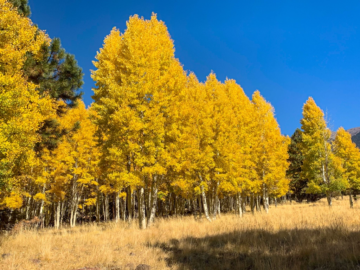
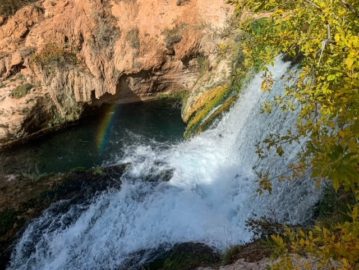
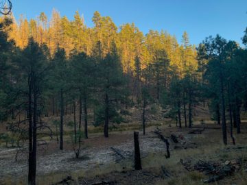
Hiking Amazing Arizona: Flagstaff’s Spectacular Aspen Loop
…
Read More
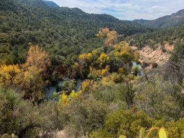
Hike Amazing Arizona: Beautiful Fossil Springs Wilderness – FR 708
…
Read More
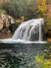
Beautiful Fossil Creek Wilderness – Waterfall Trail: Hike Amazing Arizona
…
Read More
Hike Amazing Arizona: Beautiful Fossil Creek Wilderness – Flume Trail
…
Read More
Fossil Springs Wilderness: Spectacular Fossil Springs Trail (Hiking Amazing Arizona)
…
Read More
Thruhiking the Amazing, Spectacular Arizona Trail: Mogollon Rim-Washington Park
…
Read More
Thruhiking the Amazing, Spectacular Arizona Trail – Clear Creek-Mogollon Rim
…
Read More
Thruhiking the Amazing, Spectacular Arizona Trail: MM 274.5-MM 286.7 SOBO
…
Read More
Amazing, Spectacular Arizona Trail Thruhiking, Shuff Tank-MM 274.5
…
Read More
Arizona Trail: Mormon Lake (Towns of the Road Trips & Trails)
…
Posts pagination
1
2
3
Next page
Type your email…
Subscribe
Facebook
Twitter
Instagram
Recent Posts
Beautiful Baxter State Park: Wassataquoik Lake & Green Falls (Part 2)
Beautiful Baxter State Park: Wassataquoik Lake & Green Falls (Part 1)
Beautiful Red Cliffs Desert Reserve: Sand Hill/Dino Cliffs Loop
Beautiful Katahdin Woods & Waters NM: Spectacular Mountain Views
How to Plan Around the Potential Impacts of a Government Shutdown on National Parks and Public Lands
Recent Comments
Aspen
on
Amazing, Spectacular Arizona Trail: Northern Trailhead-Buckskin Mountain Camp (Day 1)
Pink Gelatin Trick
on
Amazing, Spectacular Arizona Trail: Northern Trailhead-Buckskin Mountain Camp (Day 1)
Aspen
on
Amazing, Spectacular Arizona Trail: Babbitt Ranch Campsite-Missouri Bill Hill
Pens ve Tutucular
on
Amazing, Spectacular Arizona Trail: Babbitt Ranch Campsite-Missouri Bill Hill
Matkap Uçları
on
Everything You Need to Know About the America the Beautiful Federal Lands Pass
Archives
December 2023
September 2023
August 2023
July 2023
June 2023
May 2023
April 2023
March 2023
February 2023
January 2023
December 2022
October 2022
September 2022
August 2022
July 2022
June 2022
October 2020
September 2020
August 2020
July 2020
June 2020
May 2020
April 2020
March 2020
February 2020
January 2020
Categories
Arizona
Arizona
Arizona State Parks
Arizona Trail Approach
Backpacking
Baxter State Park
BLM Land
California
Castle Mountains National Monument
Cedar Breaks National Monument
Central Arizona (Passages 26-14)
Chickasaw National Recreation Area
Coconino National Forest
Coconino National Forest
Cottonwood Canyon Wilderness
Day Hiking
Footwear
Fossil Creek Wilderness
Fossil Springs Wilderness
Four Peaks Wilderness
Gear
Glen Canyon NRA
Grand Canyon National Park
Grand Canyon Wilderness
Great Basin National Park
Hiking
Kaibab National Forest
Maine
Maine State Parks
Massachusetts
Mazatzal Wilderness
Missouri
National Conservation Areas & BLM National Monuments
National Forest
National Forests
National Park Week
National Parks
Nevada
New Mexico
Northern Arizona (Passages 43-26)
Oklahoma
Paria Canyon-Vermilion Cliffs Wilderness
Passage 15: Tortilla Mountains
Passage 16: Gila River Canyons
Passage 17: Alamo Canyon
Passage 18: Reavis Canyon
Passage 19: Superstition Wilderness
Passage 20: Four Peaks
Passage 21: Pine Mountain
Passage 22: Saddle Mountain
Passage 23: Mazatzal Divide
Passage 24: Red Hills
Passage 25: Whiterock Mesa
Passage 26: Highline
Passage 27: Blue Ridge
Passage 28: Happy Jack
Passage 29: Mormon Lake
Passage 30: Anderson Mesa
Passage 31: Walnut Canyon
Passage 32: Elden Mountain
Passage 33: Flagstaff
Passage 34: San Francisco Peaks
Passage 35: Babbitt Ranch
Passage 36: Coconino Rim
Passage 37: Grand Canyon South Rim
Passage 38: Grand Canyon
Passage 39: Grand Canyon North Rim
Passage 40: Kaibab Plateau South
Passage 41: Kaibab Plateau Central
Passage 42: Kaibab Plateau North
Passage 43: Buckskin Mountain
photography
public lands
Red Cliffs NCA
Resupply Towns
Road Trips
Saddle Mountain Wilderness
Sand Hollow SP
Snow Canyon SP
Snowshoeing
State Parks
Superstition WIlderness
The Arizona Trail
thruhiking
thruhiking
Tonto National Forest
Trail Entries & Logistics
Travel
Utah
Utah State Parks
Vermilion Cliffs National Monument
Walnut Canyon National Monument
wilderness
WIlson’s Creek National Battlefield
Zion NP
Meta
Register
Log in
Entries feed
Comments feed
WordPress.org

Recent Comments