This morning starts with a stop at my last national park in northern Arizona, Walnut Canyon National Monument.
Walnut Canyon History
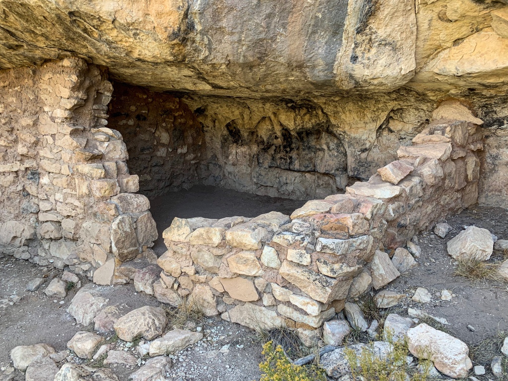
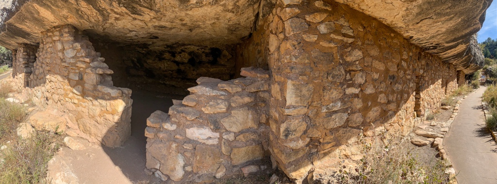
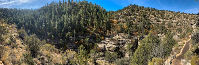
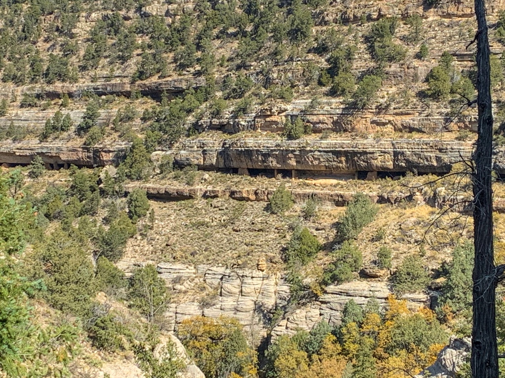
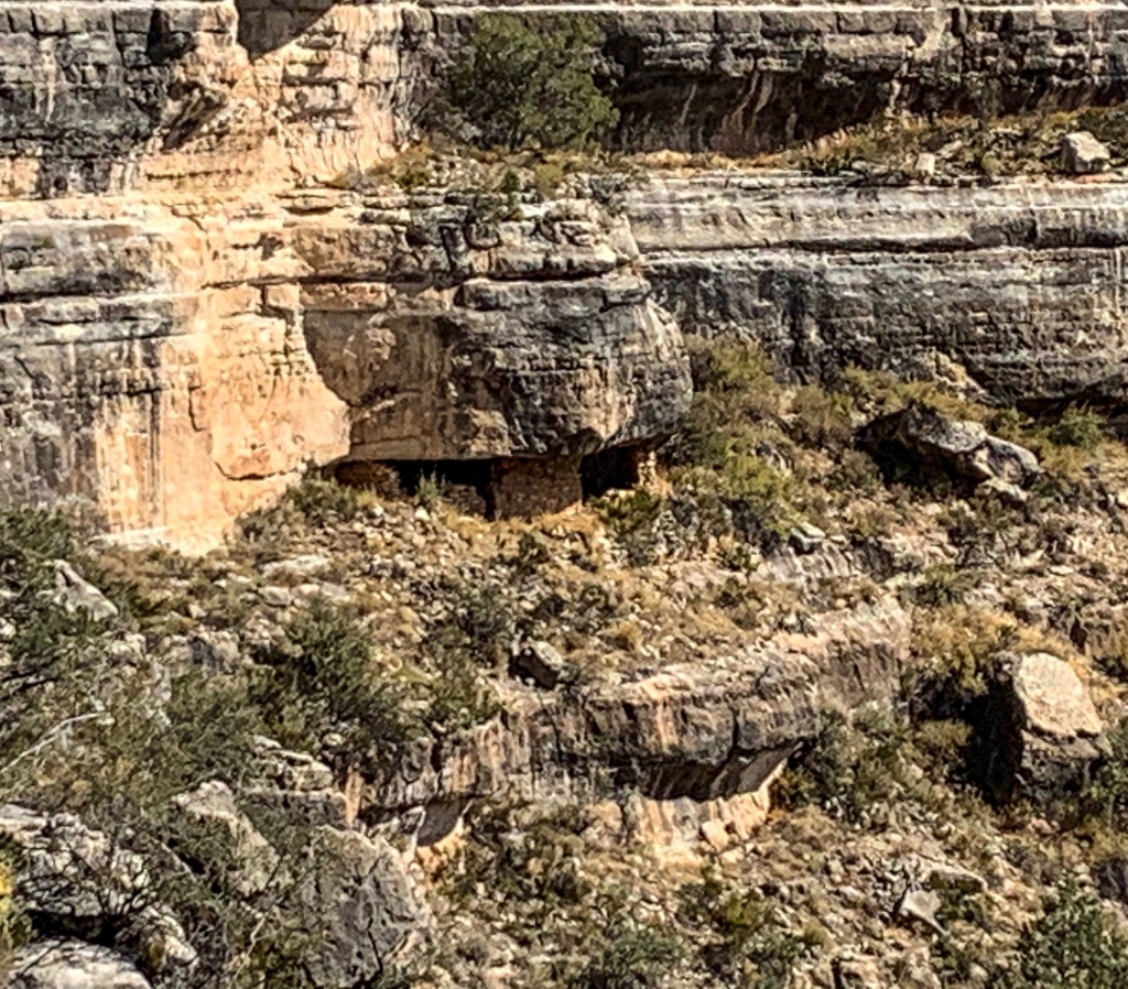
Walnut Canyon National Monument protects over 80 cliff dwellings of the Northern Sinagua people. Named for the historic Spanish name for the general region, Sierra de Sin Agua, or “mountains without water,” the Sinagua people built the dwellings between 1125 and 1250 CE. The dwellings are, as the name suggests, located in Walnut Canyon, a 20 mile long, 400 ft deep and quarter mile wide canyon carved by Walnut Creek in the Mogollon Plateau southeast of Flagstaff. Most are near the Island Trail that rings a peninsula of rock that Walnut Creek bends around, connected to the north rim of a canyon by a narrow ridge of rock, giving the peninsula the appearance of an island. Each room, built under limestone ledges, might have housed a family. The ledges afforded protection from the elements – they kept the dwellings cool in the summer and warm in the winter. They were also easier to defend against invasion.
Prior to building the cliff dwellings, the Sinagua lived and cultivated areas on the rim of the canyon. In a dry, semi-arid landscape – though not as harsh as some found further south – the communities relied on the intermittent flow of water in Walnut Creek for sustenance. It is not clear why the dwellings were abandoned around 1250, but suspected reasons include drought and relations with neighboring tribes. National Monument also protects natural resources, including 387 species of plants as well as marine fossils remaining from when the area was located under a sea.
Starting in the 1880s, theft and looting became an issue at Walnut Canyon as construction of the Atchison, Topeka and Santa Fe Railroad brought more people to the region. By 1915, alarm among local citizens led President Wilson to establish Walnut Canyon National Monument, first under the US Forest Service as part of Coconino National Forest, then the National Park Service starting in 1934. In the 1930s, the Civilian Conservation Corps built trails and buildings, stabilized the walls of various cliff dwellings, and led guided tours. Further expansions of the site in 1938 by President Roosevelt and 1994 by President Clinton added additional stretches of the canyon into the monument, bringing it to its current 3600 acres of protected resources.

Walnut Canyon National Monument

Walnut Canyon National Monument
Visiting Walnut Canyon
When to Go
Year-round park, but take traction for winter visits if you plan to visit in the winter.
Things to Do & Highlights
- Hiking (2 paved trails, Island Trail and Rim Trail)
- Historical cliff dwelling views, up close and farther away
- Visitor center with film and exhibits
Your visit will almost certainly incorporate at least one of the two trails within the park, the Island Trail and the Rim Trail, so we’ll detail the two. Note that the Island Trail, the highlight of the park, is accessed directly through the visitor center and therefore is not accessible outside of the hours the visitor center is open. The Rim Trail is open sunrise to sunset.
Island Trail
The Island Trail is without question the highlight of the park. As noted above, since one passes through the visitor center in order to access the trail, one cannot access this trail outside of normal visitor center hours, so it is highly recommended that you plan to be at Walnut Canyon while the visitor center is open, even though the park is technically open sunrise to sunset. The immersive experience provided by the Island Trail is unmatched by the Rim Trail or views from the rim, splendid though they are. The Island Trail may close in periods of snow or ice, so check the forecast and conditions on the park website (below) in advance of arriving at the park so you are aware of the conditions you will encounter on your visit and whether or not this trail will be an option for you.
Exiting the rear of the visitor center, the Island Trail drops 185 ft down into Walnut Canyon and then wraps around the “island” – actually a peninsular bend of Walnut Creek. It proceeds in a loop around the island, passing numerous Sinagua cliff dwellings and interpretive signs along the way, along with views of other ones throughout the canyon. The 1 mile loop concludes by ascending the same 185 ft back out of the canyon that you descended at the outset.


Walnut Canyon National Monument

Walnut Canyon National Monument

Walnut Canyon National Monument

Walnut Canyon National Monument

Walnut Canyon National Monument
Walnut Canyon National Monument

Walnut Canyon National Monument

Walnut Canyon National Monument

Walnut Canyon National Monument (a national park, managed by the National Park Service, Arizona)

Walnut Canyon National Monument (a national park, managed by the National Park Service, Arizona)

Walnut Canyon National Monument (a national park, managed by the National Park Service, Arizona)

Walnut Canyon National Monument (a national park, managed by the National Park Service, Arizona)

Walnut Canyon National Monument

Walnut Canyon National Monument
Walnut Canyon National Monument (a national park, managed by the National Park Service, Arizona)

Walnut Canyon National Monument
Walnut Canyon National Monument (a national park, managed by the National Park Service, Arizona)

Walnut Canyon National Monument

Walnut Canyon National Monument

Walnut Canyon National Monument (a national park, managed by the National Park Service, Arizona)

Walnut Canyon National Monument (a national park, managed by the National Park Service, Arizona)
Walnut Canyon National Monument (a national park, managed by the National Park Service, Arizona)
Walnut Canyon National Monument (a national park)

Rim Trail
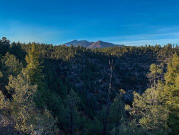
The Rim Trail is the second trail at the monument. 0.7 miles long, the Rim Trail passes several scenic viewpoints into the Canyon, features views of Elden Mountain and the San Francisco Peaks near Flagstaff, and also passes a pueblo and pit house archeological site on the canyon rim. This trail is open year round, but bring traction for the cold months.

Walnut Canyon National Monument, Arizona

Walnut Canyon National Monument, Arizona

Walnut Canyon National Monument, Arizona

Walnut Canyon National Monument, Arizona

Walnut Canyon National Monument
Can you spot the dwellings?

Cliff dwellings on the walls of Walnut Canyon
Walnut Canyon National Monument
Can you spot the dwellings?


Walnut Canyon National Monument, Arizona

Walnut Canyon National Monument (one of 22 national parks in Arizona)

Walnut Canyon National Monument (one of 22 national parks in Arizona)

Walnut Canyon National Monument, one of 22 national parks in Arizona
Walnut Canyon National Monument (one of 22 national parks in Arizona)
Walnut Canyon National Monument (one of 22 national parks in Arizona)
Walnut Canyon National Monument (one of 22 national parks in Arizona)
Accommodations, Camping and Other Services
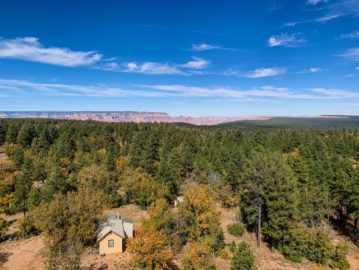
The closest accommodations and food services are in the city of Flagstaff a short drive west on I-40. For an overview of options in Flagstaff, check out my article specifically on the city, a worthy destination in itself. Backcountry camping can be done just outside the National Monument Boundary along the Arizona Trail, but is only accessible by foot.
Park Contact & Directions Information
Visitor Center:
Exit 204 off I-40, 10 miles east of Flagstaff, Arizona (dead end road at visitor center)
Park phone number: 928-526-3367
Park Website: www.nps.gov/waca
Nearby Recommended Attractions En Route
- East (via I-40/Historic US-66)
- Winslow, Arizona
- Town made famous in “Route 66” and “Take it Easy,” still retains a segment of 66 running through town
- Petrified Forest National Park
- National Park dedicated to one of the biggest concentrations of petrified wood around, spanning 346 square miles
- Hubbell Trading Post National Historic Site
- Winslow, Arizona
- North(via Navajo Nation)
- Canyon de Chelly National Monument
- Set of scenic and historic canyons on the Navajo Nation with archeological sites and an Ansel Adams connection
- Navajo National Monument
- Set of two Ancestral Puebloan archeological sites on the Navajo Nation
- Monument Valley
- Scenic sandstone landscape on the Arizona/Utah border and Navajo Nation
- Grand Falls (unpaved roads required)
- Canyon de Chelly National Monument
- West and Northwest (via I-40, Historic Route 66, and US-89)
- Flagstaff
- Largest city in northern Arizona, a college town with abundant outdoor recreation, quirky charm, a vibrant food and drink scene, and Route 66 history
- Lowell Observatory
- Site of the discovery of Pluto
- Sunset Crater Volcano National Monument (currently closed due to the Pipeline Fire)
- Site of the most recent eruption in the San Francisco Volcanic Field
- Wupatki National Monument
- Dense collection of archeological sites on the east side of
- Grand Canyon South Rim
- Primary visitor area on the south rim of Grand Canyon
- Grand Canyon North Rim
- Primary visitor area on the north rim of Grand Canyon
- For more information on visiting the North Rim, check out:
- Vermilion Cliffs National Monument
- Red rock cliffs on the boundary of the Paria Plateau, lowest section of the “Grand Staircase” that climbs from the Colorado River in Grand Canyon to the top of the Aquarius and Paunsaugunt Plateaus in Utah
- Glen Canyon National Recreation Area
- Beautiful red rock canyon landscape home to famous locations such as Lake Powell and Horseshoe Bend
- Arizona Trail
- 800+ mile multiple use trail crossing Arizona from north to south
- Flagstaff
- South (via I-40, AZ-89A, and I-17)
- Sedona
- Magical red rock landscape
- Mogollon Rim
- Southern boundary of the Colorado Plateau with 4000 foot sheer drops into central Arizona
- Mormon Lake
- Largest natural lake in Arizona
- Arizona Trail
- Sedona
Walnut Canyon Trail Logistics & Ecology
| Rim Trail | Island Trail | |
| Type of hike | Out & back | Loop |
| Trail Surface | Paved trail | Paved Trail |
| Length (Mi) | 0.7 | 1 |
| Season | All year | All year. Stairs may get icy in winter. Snowy & icy conditions can lead to closure of the trail. |
| Major attributes | Good view of variety of cliff dwelling structure remains throughout the central portion of Walnut Canyon. Rim-top pueblo. | Loop trail providing close-up view of cliff dwellings in inner canyon |
| Potential Water Sources | Walnut Canyon Visitor Center | Walnut Canyon Visitor Center |
| Trailheads | Visitor Center | Visitor Center |
| Trailhead Access | Vehicular (paved road) | Vehicular (paved road) |
| Wilderness | No | No |
| Difficulty | Easy | Strenuous. 185 feet descent into canyon at 7000’ elevation. |
| Potential campsites (mileages S to N) | Hiking/Backpacking campsites available along Arizona Trail on borders of park | Hiking/Backpacking campsites available along Arizona Trail on borders of park |
| Ecosystems Traversed | Rocky Mountain Montane Conifer Woodland | Rocky Mountain Montane Conifer Woodland |
| Accessible? | Yes | No |
| Rocky Mountain Montane Conifer Woodland | |
| Common Trees/Shrubs | * Ponderosa Pine * Southwestern white pine * Subalpine fir * White fir * Rocky Mountain maple * Bigtooth maple * Grey alder * Red birch * Red osier dogwood * Cliffbush * Mallow ninebark * New Mexican locust * huckleberry * bilberries |
| Common herbaceous plants | * fringed brome * Geyer’s sedge/elk sedge * Ross’ sedge * Bronze sedge/dry land sedge/hillside sedge/hay sedge/Fernald’s hay sedge * screwleaf muhly * bluebunch wheatgrass * Spruce-fir fleabane * wild strawberry/Virginia strawberry * Small-flowered woodrush * mountain sweet Cicely * bittercress ragwort * western meadow-rue * Fendler’s meadow-rue |
One thought on “Beautiful Walnut Canyon NM: Sinagua Cliff Dwelling History”