AZT Passage 16: Gila River Canyons
Arizona Trail Day 64, Part 2
Trans-Arizona/Utah Day 72, Part 2
Welcome back to Aspen’s Tracks, thruhiking the Arizona Trail southbound from Utah to Mexico. Today’s route covers backpacking the stretch of Passage 16, the Gila River Canyons, between the northern passage boundary at the Tonto National Forest’s southern edge to beginning of the descent toward the Gila River. You can find today’s hiking logistics below the photo documentation and trail journal of the route.
If you missed my last entry covering the leg through the last segment of the Alamo Canyon passage, that can be found here. The next entry will cover the descent to the Gila River and the week will conclude chronicling the continued journey along the Gila toward the crossing at the Kelvin-Riverside Bridge. If you enjoy these accounts, please do subscribe to follow along to make sure that you don’t miss out on here or any future accounts to come!
(Note: the photos herein are smaller and at 50% quality, however, full quality ones are available to those interested, please contact me separately if so. This change was made to speed page loading but if you would prefer the full quality images please leave a comment to let me know).
In the land of Arizona
“The Arizona Trail,” Dale R Shewalter
Through desert heat or snow
Winds a trail for folks to follow
From Utah to Old Mexico
It’s the Arizona Trail
A pathway through the great Southwest
A diverse track through wood and stone
Your spirit it will test
Some will push and pedal
And some will hike or run
Others will ride their horse or mule
What else could be more fun?
Oh, sure you’ll sweat and blister
You’ll feel the miles each day
You’ll shiver at the loneliness
Your feet and seat will pay
But you’ll see moonlight on the borderlands
You’ll see stars on the Mogollon
You’ll feel the warmth of winter sun
And be thrilled straight through to bone
The aches and pains will fade away
You’ll feel renewed and whole
You’ll never be the same again
With Arizona in your soul
Along the Arizona Trail
A reverence and peace you’ll know
Through deserts, canyons, and mountains
From Utah to Old Mexico

Arizona Trail, Passage 16
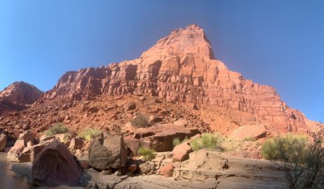
Arizona Trail: Tonto National Forest Boundary-Martinez Canyon Overlook
Having filled up on water, around 2-3 L, I head south through the Gila River Canyons. The trail hugs the cliff high above the canyon floors, winding in and out of side drainages and crossing ridgelines between canyons. As I hoped, the side drainages do indeed have trickling streams from the recent rain, so I’m feeling more confident about the water situation as the miles roll by.

Arizona Trail, Passage 16

Arizona Trail, Passage 16 (Gila River Canyons)

Arizona Trail, Passage 16 (Gila River Canyons)

Arizona Trail, Passage 16 (Gila River Canyons)

Arizona Trail Passage 16 (Gila River Canyons)

AZT Passage 16 (Gila River Canyons)

AZT Passage 16 (Gila River Canyons)

Arizona Trail, Passage 16 (Gila River Canyons)

Arizona Trail, Passage 16 (Gila River Canyons)

Arizona Trail, Passage 16 (Gila River Canyons)

Arizona Trail, Passage 16 (Gila River Canyons)

Arizona Trail, Passage 16 (Gila River Canyons)

Arizona Trail, Passage 16 (Gila River Canyons)

Arizona Trail, Passage 16 (Gila River Canyons)

Arizona Trail, Passage 16 (Gila River Canyons)

AZT Passage 16

Arizona Trail, Passage 16 (Gila River Canyons)


Arizona Trail, Passage 16 (Gila River Canyons)


Arizona Trail Passage 16 (Gila River Canyons)

AZT Passage 16 (Gila River Canyons)
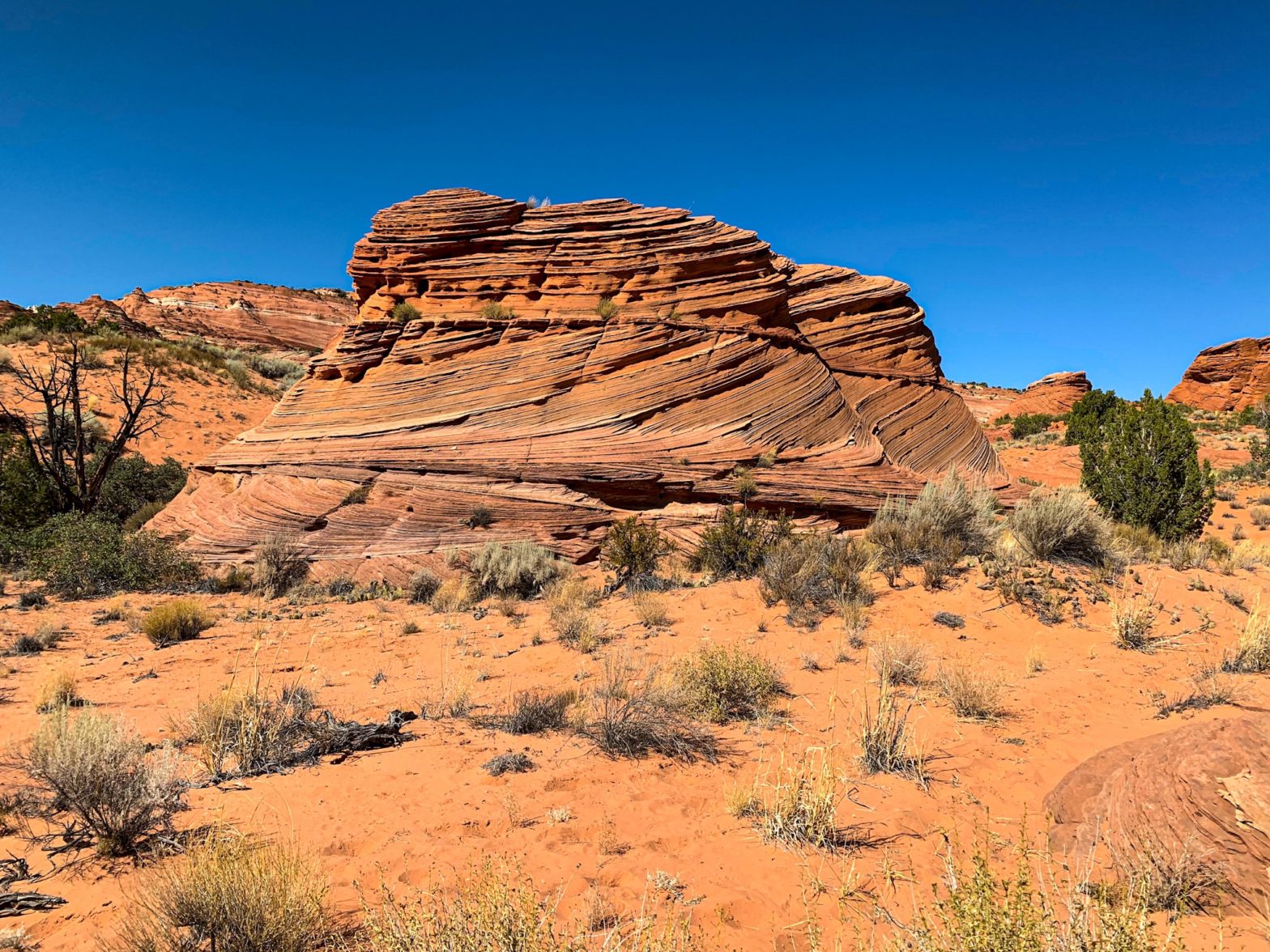
At the southernmost point of the traverse along the canyons, a view into rugged Martinez Canyon appears before crossing a rugged pass. Colorful, rugged rocks seem to jut up from the entire landscape, the power of wind and water erosion on full display.

AZT Passage 16 (Gila River Canyons)

Arizona Trail, Passage 16 (Gila River Canyons)

Arizona Trail, Passage 16 (Gila River Canyons)

Arizona Trail, Passage 16 (Gila River Canyons)

Arizona Trail, Passage 16 (Gila River Canyons)
Arizona Trail: Passage 16 Logistics
| Passage 16 (Gila River Canyons) | |
| AZTA Page and Map | Passage 16 (Gila River Canyons) Passage 16 Map Passage 16 Elevation Profile |
| Weather | Passage 16 Weather |
| Trail Surface | Dirt Singletrack |
| Length (Mi) | 25.7 |
| Season | September-May |
| Potential Water Sources | Gila River is unreliable and must be prefiltered and/or settled when flowing. Walnut Canyon may have water. Full sources & Current Status: Arizona Trail Water Sources |
| Trailheads | North: Tonto National Forest boundary South: Kelvin-Riverside Bridge |
| Trailhead Access | North: No vehicular access South: Vehicular access via paved road |
| Wilderness | No |
| Possible resupply points | Superior (north end) Kearny (south end, requires roadwalk or hitch) |
| ATA-Rated Difficulty | Difficult |
| Potential campsites | Terrain is pretty dry and rugged, but there are numerous campsites along the section paralleling the Gila River. |
| Ecosystems Traversed | Arizona Upland, mostly Riparian along the Gila River |
| Highlights | Rugged canyon scenery Gila River Walnut Canyon Wildlife |
| Dog friendly? | Yes |
| Bike friendly? | Yes |
| Hazards | One of driest passage on trail. Gila River is unreliable and must be prefiltered and/or settled when flowing. Walnut Canyon may have water. Extreme Heat in summer Flash flooding during monsoon (July-September) |

Arizona Trail, Passage 16 (Gila River Canyons)

Arizona Trail Passage 16, Gila River Canyons

Arizona Trail Passage 16, Gila River Canyons

Arizona Trail Passage 16, Gila River Canyons

Arizona Trail Passage 16, Gila River Canyons
Arizona Trail: Passage 16 Ecology
| Arizona Upland | Riparian | |
| Common Trees/Shrubs | * Fairy duster * Blue and littleleaf palo verde * Fremont wolfberry * Graythorn * Ocotillo * Red barberry * Scrub-live oak * Snapdragon-penstemon * Turpentine bush * Velvet mesquite * Whitethron acacia | * Fremont Cottonwood * Tamarisk/salt cedar (invasive) * Goodding’s willow |
| Common herbaceous plants | * California flannelbush [rare in Arizona, Superstition Mountains included] * Bluedicks * Brittlebush * California poppies * Creamcups * Desert chicory * Desert rockpea * Desert windflower * Fringed red maids * Globemallows * Lupines * Sego-lily | |
| Common succulents | * Arizona pencil cholla * Banana yucca * Soaptree yucca * Buckhorn cholla * Cane cholla * Chainfruit * Hedgehog cactus * Pencil cholla * Pincushion cactus * Prickly pears * Saguaro * Teddybear cholla |