Arizona Trail, Passage 18 & 17: Reavis Canyon, Part II and Alamo Canyon, Part I
AZT Day 63
Trans-Arizona/Utah Day 71
Welcome back to Aspen’s Tracks, thruhiking the Arizona Trail southbound from Utah to Mexico. Today’s route covers backpacking the last stretch of Passage 18 (Reavis Canyon) and the upper stretch of Passage 17 (Alamo Canyon) past Picketpost Mountain to an overlook of Alamo Canyon. You can find today’s hiking logistics below the photo documentation and trail journal of the route.
In the land of Arizona
“The Arizona Trail,” Dale R Shewalter
Through desert heat or snow
Winds a trail for folks to follow
From Utah to Old Mexico
It’s the Arizona Trail
A pathway through the great Southwest
A diverse track through wood and stone
Your spirit it will test
Some will push and pedal
And some will hike or run
Others will ride their horse or mule
What else could be more fun?
Oh, sure you’ll sweat and blister
You’ll feel the miles each day
You’ll shiver at the loneliness
Your feet and seat will pay
But you’ll see moonlight on the borderlands
You’ll see stars on the Mogollon
You’ll feel the warmth of winter sun
And be thrilled straight through to bone
The aches and pains will fade away
You’ll feel renewed and whole
You’ll never be the same again
With Arizona in your soul
Along the Arizona Trail
A reverence and peace you’ll know
Through deserts, canyons, and mountains
From Utah to Old Mexico
After three days waiting for the weather to clear in Superior, and a slow start this morning (it always feels like the more days I have spent in a town, the slower I am to get on trail the following day.) Al gives me a lift back out to Rogers Trough trailhead to resume my southbound journey on the Arizona Trail. (He would normally drop one off at Picketpost, but since I had wrapped at Rogers Trough prior to the storm instead, and being a purist, I insisted on Rogers Trough.)


Arizona Trail, Passage 18 (Reavis Canyon)
Tonto National Forest
Arizona Trail: Rogers Trough-Lower Alamo Canyon
The trail departs Rogers Trough & heads along Queen Creek, which is flowing well after the recent storm. Crossing US-60, the AZT passes through Picketpost Trailhead and rounds Picketpost Mountain, providing much better views of it than I had from the north side the other day (largely due to sun angles). Along the way, it provides great views back toward the Superstitions to the north and Apache Leap above Superior to the northeast.

Arizona Trail, Passage 18 (Reavis Canyon)

Arizona Trail, Passage 18 (Reavis Canyon)
Tonto National Forest

Arizona Trail, Passage 18 (Reavis Canyon)
Tonto National Forest

Arizona Trail, Passage 18 (Reavis Canyon)
Tonto National Forest

AZT Passage 18 (Reavis Canyon)
Tonto National Forest

AZT Passage 18 (Reavis Canyon)
Tonto National Forest

Arizona Trail Passage 18 (Reavis Canyon)
Tonto National Forest

Arizona Trail, Passage 18 (Reavis Canyon)
Tonto National Forest

AZT Passage 18 (Reavis Canyon)
Tonto National Forest

Arizona Trail, Passage 18 (Reavis Canyon)
Tonto National Forest

AZT Passage 18 (Reavis Canyon)
Tonto National Forest

AZT Passage 18 (Reavis Canyon)
Tonto National Forest

AZT Passage 18 (Reavis Canyon)
Tonto National Forest

Arizona Trail, Passage 18 (Reavis Canyon)
Tonto National Forest
![A brown metal sign with the Arizona Trail logo in the shape of the National Trails System logo stands among Sonoran desert plants. With a blue sky behind, the sign reads: “Rogers Rough TH 19 [miles], Utah 499 [miles]”](https://i0.wp.com/aspenstracks.com/wp-content/uploads/2022/12/9202D809-504A-48E0-BACA-1316A60E8133-scaled.jpeg?fit=640%2C853&ssl=1)
AZT Passage 17: Alamo Canyon
Tonto National Forest
Picketpost Trailhead-Upper Alamo Canyon
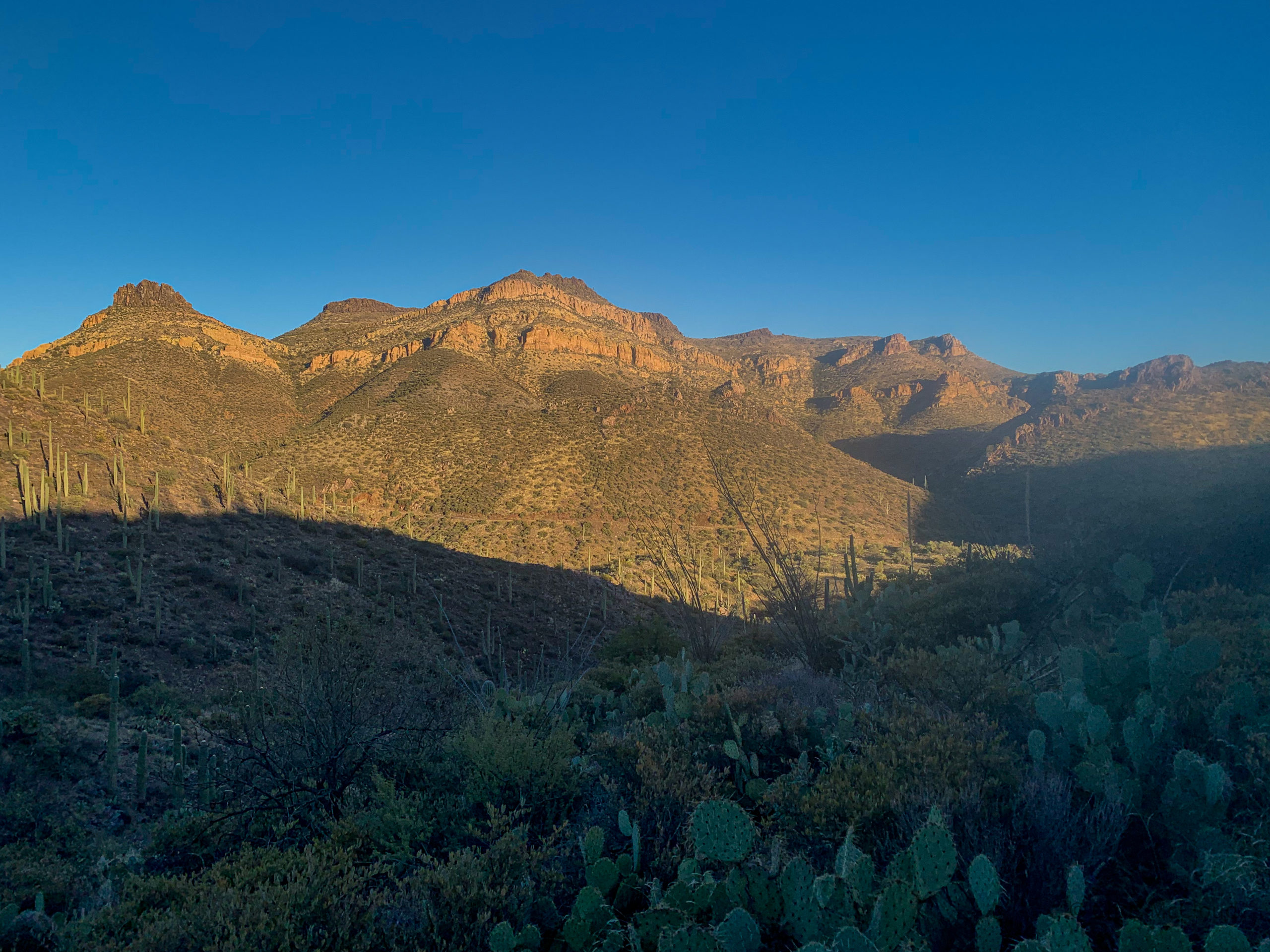
The trail exits the Picketpost Trailhead and continues southbound, following the wash that flows out of lower Alamo Canyon. I consider doing the side hike to the top of Picketpost, which is highly recommended, but ultimately decide that I both don’t have the time and it would be a fairly easy day hike on a future trip to the region, so I hold off for now. Both the more mountainous Superstitions in their eastern portion, which the trail passed through, and the more chiseled western Superstitions, containing such famous features as Weaver’s Needle, are visible at various points as the trail climbs along a wash and up the hills of lower Alamo Canyon.

Arizona Trail, Passage 17 (Alamo Canyon)
Tonto National Forest

Arizona Trail, Passage 17 (Alamo Canyon)
Tonto National Forest

Arizona Trail, Passage 17 (Alamo Canyon)
Tonto National Forest


AZT Passage 17 (Alamo Canyon)
Tonto National Forest

Arizona Trail, Passage 17 (Alamo Canyon)
Tonto National Forest

AZT Passage 17 (Alamo Canyon)
Tonto National Forest

Arizona Trail, Passage 17 (Alamo Canyon)
Tonto National Forest

AZT Passage 17 (Alamo Canyon)
Tonto National Forest

Arizona Trail, Passage 17 (Alamo Canyon)
Tonto National Forest

AZT Passage 17 (Alamo Canyon)
Tonto National Forest

Arizona Trail Passage 17 (Alamo Canyon)
Tonto National Forest

AZT Passage 17 (Alamo Canyon)
Tonto National Forest

Arizona Trail, Passage 17 (Alamo Canyon)
Tonto National Forest


AZT Passage 17 (Alamo Canyon)
Tonto National Forest
Arizona Trail: Upper Alamo Canyon
Climbing toward upper Alamo Canyon, the landscape gets more and more rugged. I encounter a section hiker wrapping up their final portion of the trail, the Alamo-Gila River Canyons leg. It’s always great to encounter folks who are nearly done with 800+ mile hikes! Hopefully that is company that I will be in shortly, but I still have a little ways to go. As the trail ascends toward the Tonto National Forest boundary and the start of the Gila River Canyons passage, I find a perfect spot for sunrise tomorrow to get back in a trail groove, and pause for the night.
Upper Alamo Canyon Images

Picketpost Mountain & western Superstitions on left, eastern arm of Superstitions & Apache Leap in center, Alamo Canyon foothills to right
Arizona Trail, Passage 17 (Alamo Canyon)
Tonto National Forest

Arizona Trail, Passage 17 (Alamo Canyon)
Tonto National Forest

AZT Passage 17 (Alamo Canyon)
Tonto National Forest

Arizona Trail, Passage 17 (Alamo Canyon)
Tonto National Forest

Arizona Trail, Passage 17 (Alamo Canyon)
Tonto National Forest

AZT Passage 17 (Alamo Canyon)
Tonto National Forest

Arizona Trail, Passage 17 (Alamo Canyon)
Tonto National Forest

Arizona Trail, Passage 17 (Alamo Canyon)
Tonto National Forest

Arizona Trail, Passage 17 (Alamo Canyon)
Tonto National Forest

Arizona Trail, Passage 17 (Alamo Canyon)
Tonto National Forest

Arizona Trail, Passage 17 (Alamo Canyon)
Tonto National Forest

Arizona Trail, Passage 17 (Alamo Canyon)
Tonto National Forest

Arizona Trail, Passage 17 (Alamo Canyon)
Tonto National Forest

Arizona Trail, Passage 17 (Alamo Canyon)
Tonto National Forest

AZT Passage 17 (Alamo Canyon)
Tonto National Forest

Arizona Trail, Passage 17 (Alamo Canyon)
Tonto National Forest
Passage 17-18 Logistics
| Passage 18 (Reavis Canyon) | Passage 17 (Alamo Canyon) | |
| AZTA Page and Map | Passage 18 (Reavis Canyon) Passage 18 Map Passage 18 Elevation Profile | Passage 17 (Alamo Canyon) Passage 17 Map Passage 17 Elevation Profile |
| Weather | Passage 18 Weather | Passage 17 Weather |
| Trail Surface | Dirt singletrack Some short dirt road stretches just north of US-60 | Dirt Singletrack |
| Length (Mi) | 19 | 11.7 |
| Season | September-May | September-May |
| Potential Water Sources | Mud Spring (Mi 312.1 NB, 476.4 SB) Reavis Trail Canyon (mi 312.2 NB, 476.3 SB) Whitford Canyon Creek (mi 306.3 NB, 482.1 SB) Queen Creek (mi 301.7 NB, 486.7 SB) Picketpost Trailhead Resupply Box (mi 300.6 NB, 487.9 SB) Full sources & Current Status: Arizona Trail Water Sources | Picketpost Trailhead Resupply Box (mi 300.6 NB, 487.9 SB) Arnett Canyon Trail Junction (mi 300.3 NB, 488.2 SB) Small Flow (mi 297.6 NB, 490.9 SB) Drainage & Water (mi 290.2 NB, 498.3 SB) Rainwater Collector (mi 289.1 NB, 499.3 SB) Full sources & Current Status: Arizona Trail Water Sources |
| Trailheads | North: Rogers Trough Trailhead South: Picketpost Mountain Trailhead | North: Picketpost Trailhead South: Tonto National Forest boundary |
| Trailhead Access | North: Vehicular access; via USFS road South: Vehicular access via paved road | North: Vehicular access; via paved road South: No vehicular access |
| Wilderness | Yes | No |
| Possible resupply points | Superior (south end) | Superior (north end) |
| ATA-Rated Difficulty | Moderate | Moderate |
| Potential campsites | Best sites are around the summit of Montana Mountain and just north Beware flash flooding and snakes in the Reavis Canyon drainage | Terrain is pretty dry and rugged. Your best bet is to push through this passage in a day and camp near the rainwater collector on the south end or near one of the trailheads on the north end before ascending into the Superstitions, or just after ascending to the summit of Montana Mountain |
| Ecosystems Traversed | Arizona Upland | Arizona Upland, mostly |
| Highlights | Ancient saguaros Views from Montana Mountain | Rugged canyon scenery Picketpost Mountain Views of Superstition Mountains and Apache Leap Desert flora & fauna diversity Solitude |
| Dog friendly? | Yes | Yes |
| Bike friendly? | Not in wilderness component (see AZT bike route for route around wilderness areas) | Yes |
| Hazards | Known for being one of the most prominent snake stretches. Leave them alone and they will leave you alone. Be vigilant in spring and fall in particular. Dry Extreme summer heat Flash flooding & lightning during monsoon (July-September) | Arguably driest passage on trail. Unless recent storm, AZTA water collector is only reliable source north of Gila River on passage Extreme Heat in summer Flash flooding during monsoon (July-September) |
Passages 17-18 Ecology
| Arizona Upland | |
| Common Trees/Shrubs | * Fairy duster * Blue and littleleaf palo verde * Fremont wolfberry * Graythorn * Ocotillo * Red barberry * Scrub-live oak * Snapdragon-penstemon * Turpentine bush * Velvet mesquite * Whitethron acacia |
| Common herbaceous plants | * California flannelbush [rare in Arizona, Superstition Mountains included] * Bluedicks * Brittlebush * California poppies * Creamcups * Desert chicory * Desert rockpea * Desert windflower * Fringed red maids * Globemallows * Lupines * Sego-lily |
| Common succulents | * Arizona pencil cholla * Banana yucca * Soaptree yucca * Buckhorn cholla * Cane cholla * Chainfruit * Hedgehog cactus * Pencil cholla * Pincushion cactus * Prickly pears * Saguaro * Teddybear cholla |
whoiscall
Thx
gold ira reviews top 10 gold ira companies compared
I enjoyed this-Helpful to read, but I am not sure where to start. Which of your posts can you point me to read next?