Arizona Trail Passage 19: Superstition Wilderness
AZT Day 59
Trans-Arizona/Utah Day 66
Welcome back to Aspen’s Tracks, thruhiking the Arizona Trail southbound from Utah to Mexico. Today’s route covers backpacking the stretch of Passage 19, the Superstition Wilderness, between the upper Cottonwood Creek drainage and Pine Creek in the interior of the wilderness. You can find today’s hiking logistics below the photo documentation and trail journal of the route.
If you missed my last entry covering the leg through the first segment of the passage, that can be found here. The next entry will cover the remainder of the Superstion Wilderness crossing, from Pine Creek to Rogers Trough Trailhead. If you enjoy these accounts, please do subscribe to follow along to make sure that you don’t miss out on here or any future accounts to come!
In the land of Arizona
Through desert heat or snow
Winds a trail for folks to follow
From Utah to Old Mexico
It’s the Arizona Trail
A pathway through the great Southwest
A diverse track through wood and stone
Your spirit it will test
Oh, sure you’ll sweat and blister
You’ll feel the miles every day
You’ll shiver at the loneliness
Your feet and seat will pay
But you’ll see moonlight on the borderlands
You’ll see stars on the Mogollon
You’ll feel the warmth of winter sun
And be thrilled straight through to bone
The aches and pains will fade away
You’ll feel renewed and whole
You’ll never be the same again
With Arizona in your soul
Along the Arizona Trail
A reverence and peace you’ll know
Through deserts, canyons, and mountains
From Utah to Old Mexico
-“The Arizona Trail,” Dale R. Shewalter

Superstition Wilderness
Tonto National Forest
Arizona Trail: Cottonwood Creek Basin to Superstition Wilderness Boundary, Tonto National Forest
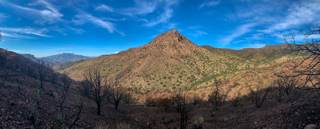
Today on the Arizona Trail started with a climb from the headwaters of Cottonwood Creek to the boundary of the Superstition Wilderness in the Tonto National Forest. As I climbed through the area burned in the Woodbury Fire that summer, the effects of the fire remained very evident all around.

Arizona Trail, Passage 19 (Superstition Wilderness)
Superstition Wilderness
Tonto National Forest

Arizona Trail, Passage 19 (Superstition Wilderness)
Superstition Wilderness
Tonto National Forest

Arizona Trail, Passage 19 (Superstition Wilderness)
Superstition Wilderness
Tonto National Forest

Arizona Trail, Passage 19 (Superstition Wilderness)
Superstition Wilderness
Tonto National Forest

Arizona Trail, Passage 19 (Superstition Wilderness)
Superstition Wilderness
Tonto National Forest

Arizona Trail, Passage 19 (Superstition Wilderness)
Superstition Wilderness
Tonto National Forest
Arizona Trail: Superstitions Wilderness Boundary to Pine Creek
Superstitions Wilderness, Tonto National Forest
The trail starts out on a forest road but then branches off and climbs into the Wilderness. The spectacular red sediment contrasts tremendously with the blue sky, streaks of clouds, vegetation, and shadows of the rugged mountains. As the trail reaches the summit of Two Bar Ridge, spectacular views emerge. The Salt River Canyon and Apache Lake between the Superstitions and southern Mazatzals come into view. Roosevelt Lake shines behind. The rugged Superstitions lie ahead, rock layers exposed and covered in all kinds of desert flora.
qPhoenix is the sixth largest city in the United States, and the Superstitions are one of the most popular hiking areas around Phoenix. However, the AZT cuts through their quieter eastern side, ensuring that the wilderness character of the trail as a whole is preserved. Wildfire impacts are visible at varying intervals. Aside from the spectacularly rugged mountains, the trail crosses through occasional grasslands dry from the summer heat, that somehow lucked out and escaped incineration by fire over the summer.

Arizona Trail, Passage 19 (Superstition Wilderness)
Superstition Wilderness
Tonto National Forest

Arizona Trail, Passage 19 (Superstition Wilderness)
Superstition Wilderness
Tonto National Forest

Arizona Trail, Passage 19 (Superstition Wilderness)
Superstition Wilderness
Tonto National Forest

Arizona Trail, Passage 19 (Superstition Wilderness)
Superstition Wilderness
Tonto National Forest

Arizona Trail, Passage 19 (Superstition Wilderness)
Superstition Wilderness
Tonto National Forest

Arizona Trail, Passage 19 (Superstition Wilderness)
Superstition Wilderness
Tonto National Forest


Arizona Trail, Passage 19 (Superstition Wilderness)
Superstition Wilderness
Tonto National Forest

Arizona Trail, Passage 19 (Superstition Wilderness)
Superstition Wilderness
Tonto National Forest

Arizona Trail, Passage 19 (Superstition Wilderness)
Superstition Wilderness
Tonto National Forest

Arizona Trail, Passage 19 (Superstition Wilderness)
Superstition Wilderness
Tonto National Forest
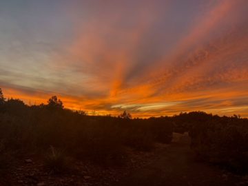
Crossing Two Bar Ridge, the trail descends into another basin ringed by soaring cliffs. Desert flora abounds as it rises again to crest a ridgeline below Two Bar Mountain. Crossing the ridgeline and a subsequent exposed area, the trail passes Walnut Spring. It’s getting dark a little while later as I reach my finish point for the day, Pine Creek. Water can be a real challenge in this area, but Pine Creek provides a great source for the night.

Arizona Trail, Passage 19 (Superstition Wilderness)
Superstition Wilderness
Tonto National Forest

Arizona Trail, Passage 19 (Superstition Wilderness)
Superstition Wilderness
Tonto National Forest

Arizona Trail, Passage 19 (Superstition Wilderness)
Superstition Wilderness
Tonto National Forest

Arizona Trail, Passage 19 (Superstition Wilderness)
Superstition Wilderness
Tonto National Forest

Arizona Trail, Passage 19 (Superstition Wilderness)
Superstition Wilderness
Tonto National Forest

Arizona Trail, Passage 19 (Superstition Wilderness)
Superstition Wilderness
Tonto National Forest


Arizona Trail, Passage 19 (Superstition Wilderness)
Superstition Wilderness
Tonto National Forest

Arizona Trail, Passage 19 (Superstition Wilderness)
Superstition Wilderness
Tonto National Forest

Superstition Wilderness
Tonto National Forest

Superstition Wilderness
Tonto National Forest

Superstition Wilderness
Tonto National Forest

Arizona Trail, Passage 19 (Superstition Wilderness)
Superstition Wilderness
Tonto National Forest

Arizona Trail, Passage 19 (Superstition Wilderness)
Superstition Wilderness
Tonto National Forest

Arizona Trail, Passage 19 (Superstition Wilderness)
Superstition Wilderness
Tonto National Forest

Arizona Trail, Passage 19 (Superstition Wilderness)
Superstition Wilderness
Tonto National Forest
Arizona Trail, Passage 19 (Superstition Wilderness)
Superstition Wilderness
Tonto National Forest

Arizona Trail, Passage 19 (Superstition Wilderness)
Superstition Wilderness
Tonto National Forest

Arizona Trail, Passage 19 (Superstition Wilderness)
Superstition Wilderness
Tonto National Forest

Arizona Trail, Passage 19 (Superstition Wilderness)
Superstition Wilderness
Tonto National Forest

Superstition Wilderness
Tonto National Forest

Superstition Wilderness
Tonto National Forest

Arizona Trail, Passage 19 (Superstition Wilderness)
Superstition Wilderness
Tonto National Forest

Arizona Trail, Passage 19 (Superstition Wilderness)
Superstition Wilderness
Tonto National Forest

Arizona Trail, Passage 19 (Superstition Wilderness)
Superstition Wilderness
Tonto National Forest

Arizona Trail, Passage 19 (Superstition Wilderness)
Superstition Wilderness
Tonto National Forest

Arizona Trail, Passage 19 (Superstition Wilderness)
Superstition Wilderness
Tonto National Forest

Arizona Trail, Passage 19 (Superstition Wilderness)
Superstition Wilderness
Tonto National Forest

Superstition Wilderness
Tonto National Forest

Superstition Wilderness
Tonto National Forest


Superstition Wilderness
Tonto National Forest

Arizona Trail, Passage 19 (Superstition Wilderness)
Superstition Wilderness
Tonto National Forest

Arizona Trail, Passage 19 (Superstition Wilderness)
Superstition Wilderness
Tonto National Forest

Arizona Trail, Passage 19 (Superstition Wilderness)
Superstition Wilderness
Tonto National Forest


Arizona Trail, Passage 19 (Superstition Wilderness)
Superstition Wilderness
Tonto National Forest


Arizona Trail, Passage 19 (Superstition Wilderness)
Superstition Wilderness
Tonto National Forest

Arizona Trail, Passage 19 (Superstition Wilderness)
Superstition Wilderness
Tonto National Forest

Arizona Trail, Passage 19 (Superstition Wilderness)
Superstition Wilderness
Tonto National Forest

Arizona Trail, Passage 19 (Superstition Wilderness)
Superstition Wilderness
Tonto National Forest

Arizona Trail, Passage 19 (Superstition Wilderness)
Superstition Wilderness
Tonto National Forest
Arizona Trail: Superstitions Geology
Many of those who hike through this spectacular area have no idea they are walking through a supervolcano. A fair number of individuals are aware that the largest that currently exists is the Yellowstone Caldera. 50 miles wide, it has an explosive history that has blown a hole in the Rocky Mountains and altered the climate within its path. The Superstitions were more like Yellowstone’s little brother. 25-15 million years ago, they erupted in three successive eruptive events. This produced the Superstition Cauldron, Goldfield Cauldron, and Tortilla Caldera. The former two are invisible today; the latter does show some surface features (hence the different terms used to refer to them). Collectively, they are known today officially as the Superstition-Goldfield Volcanic Zone or the Superstition Cauldron Complex.
While two of the three calderas no longer exhibit visible surface features, the mountains in the vicinity show plenty of evidence of the activity. Rhyolite rock and welded tuff, ash that was still so hot when it descended that it fused into a rock form, form dramatic cliffs that rise above the hillside and mountains, creating a ruggedly spectacular landscape. During its lifetime, 2500 cubic miles of ash and lava were released. Features like Weaver’s Needle and Picketpost Mountain, plus the eroded resurgent dome of the main range, remain today as reminders of these events.
Come back for my next post, which will tackle the remainder of the Superstition Wilderness, heading toward the town of Superior!
Alternatively, if you’re curious why I picked this particular undertaking, you can check out my explanation of that.
Arizona Trail: Passage 19 Logistics
| Passage 19 (Superstition Wilderness) | |
| AZTA Passage Information | Passage 19 (Superstition Wilderness) |
| AZTA Passage Elevation Profile | Passage 19 Profile |
| AZTA Passage Map | Passage 19 Map |
| Trail Surface | Forest Road (dirt) Dirt singletrack |
| Length (Mi) | 29.4 |
| Season | September-May |
| Potential Water Sources | Trail Tank (mi 344.8 NB, 443.1 SB) Cottonwood Creek (Mi 342.9 NB, 445.0 SB) Cottonwood Spring (mm 339.2 NB, 448.7 SB) Walnut Spring (mi 329.1 NB, 458.8 SB) Pine Creek (mi 327.8 NB, 460.2 SB) Reavis Creek (mi 325.3 NB, 462.6 SB) Reavis Ranch (mi 324.9 NB, 463.1 SB) Reavis Creek (mm 324.1 NB, 463.8 SB) Reavis Saddle Spring (mm 321.7 NB, 466.2 SB) Rogers Spring (mm 318.2 NB, 469.7 SB) Current AZTA Water Reports: AZTA Water Reports |
| Trailheads | North: Vineyard Trailhead South: Rogers Trough Trailhead |
| Trailhead Access | North: Vehicular access; via paved road South: Vehicular access via graded dirt road |
| Wilderness | Yes, most |
| Possible resupply points | Roosevelt Lake Marina (north end) Farther, Globe and Tonto Basin |
| ATA-Rated Difficulty | Strenuous |
| Potential campsites (mileages S to N) | Beware flash floods in the Cottonwood Creek drainage Cottonwood Creek Basin Walnut Spring Pine Creek Reavis Ranch-Reavis Creek area |
| Ecosystems Traversed | Arizona Upland |
| Highlights | Views of Four Peaks, Tonto Basin & Roosevelt Lake Volcanic history of the Superstition Mountains Desert flora & fauna diversity Far fewer people than west side of Superstitions |
Arizona Trail: Passage 19 Ecology
| Arizona Upland | |
| Common Trees/Shrubs | * Fairy duster * Blue and littleleaf palo verde * Fremont wolfberry * Graythorn * Ocotillo * Red barberry * Scrub-live oak * Snapdragon-penstemon * Turpentine bush * Velvet mesquite * Whitethron acacia |
| Common herbaceous plants | * California flannelbush [rare in Arizona, Superstition Mountains included] * Bluedicks * Brittlebush * California poppies * Creamcups * Desert chicory * Desert rockpea * Desert windflower * Fringed red maids * Globemallows * Lupines * Sego-lily |
| Common succulents | * Arizona pencil cholla * Banana yucca * Soaptree yucca * Buckhorn cholla * Cane cholla * Chainfruit * Hedgehog cactus * Pencil cholla * Pincushion cactus * Prickly pears * Saguaro * Teddybear cholla |
One thought on “Amazing Arizona Trail: Cottonwood Creek to Beautiful Pine Creek”