Beautiful Joshua Trees and Craggy Mountains: Splendid Isolation in Southeast California (Visited National Park #227)

California/Nevada Border
The Basics: Designated in 2016, Castle Mountains National Monument contains its namesake mountains as well as uncountable numbers of Joshua trees and other Mojave desert vegetation. It’s one of the 424 national parks managed by the National Park Service. Last weekend, it became my 226th national park that I’ve visited.
Things to Know for Your Visit to Castle Mountains
Castle Mountains isn’t really intended for most visitors, but for hardcore parkies traveling between Vegas and western Arizona or southeastern California it presents a tempting if often overlooked stopping point in an area many otherwise just fly through, slowing only briefly when passing through Searchlight (and probably blowing every stop line in town in the process).
Roads to access and within the monument are dirt, and there are no interpretive services. To actually cross the current park boundary, one must at least walk, or drive or ride an adequately prepared vehicle, up one of the unmaintained side roads that branch from the main one, which is an access route for a current mine inholding. AWD or 4WD is required for the side roads, as is at least medium clearance (at slow speed) with high clearance preferred. Since the side roads aren’t maintained, a single storm may change conditions greatly.
Download a copy of the park map in advance – once you reach the monument, you will not have any cell service to do so, and there are no markings on the side roads to differentiate one from another. You will need to match it to routes indicated on the map using wayfinding.
Yet, for those who come prepared, it is a rewarding detour.
My Visit to Castle Mountains
Las Vegas-California Border
I’m in the process of migrating from a field office in Arizona to one in Utah. Still, there are a few stops that I still hope to make in western Arizona and in the southern Nevada/California border region before making the ultimate transfer at the end of the month. After a weekend spent in southern Utah bringing much of my personal stuff up to my new place, I’m heading south to my current job again, hoping to make one of these stops.
Unfortunately, my southbound travel coincides with an atmospheric river arriving in the Southwest. I briefly considered leaving a day early to allow extra certainty that I’ll be able to make one of the stops, but the overnight forecast isn’t very favorable to camping. So, I hold off a day and decide to gamble that conditions at at least one of the locations will be good enough to allow a visit.
The drive south to Las Vegas, aside from strong winds, is relatively uneventful. I exit on US-95 southbound and pull over to check the radar. It’s late afternoon, and two of the three spots require a fair hike that I feel would rush things a bit too much. Meanwhile, the radar shows only light rain, if any, at Castle Mountains just south of me, so I continue down 95 to Searchlight and turn onto NV-164, the Joshua Tree Highway.
The reason for the name is very evident early on, as within a mile or so, Joshua trees crowd both sides of the road. (Yes, they exist outside of Joshua Tree National Park, that is only one of the densest concentrations of them.)


Nevada, USA
Walking Box Ranch Road
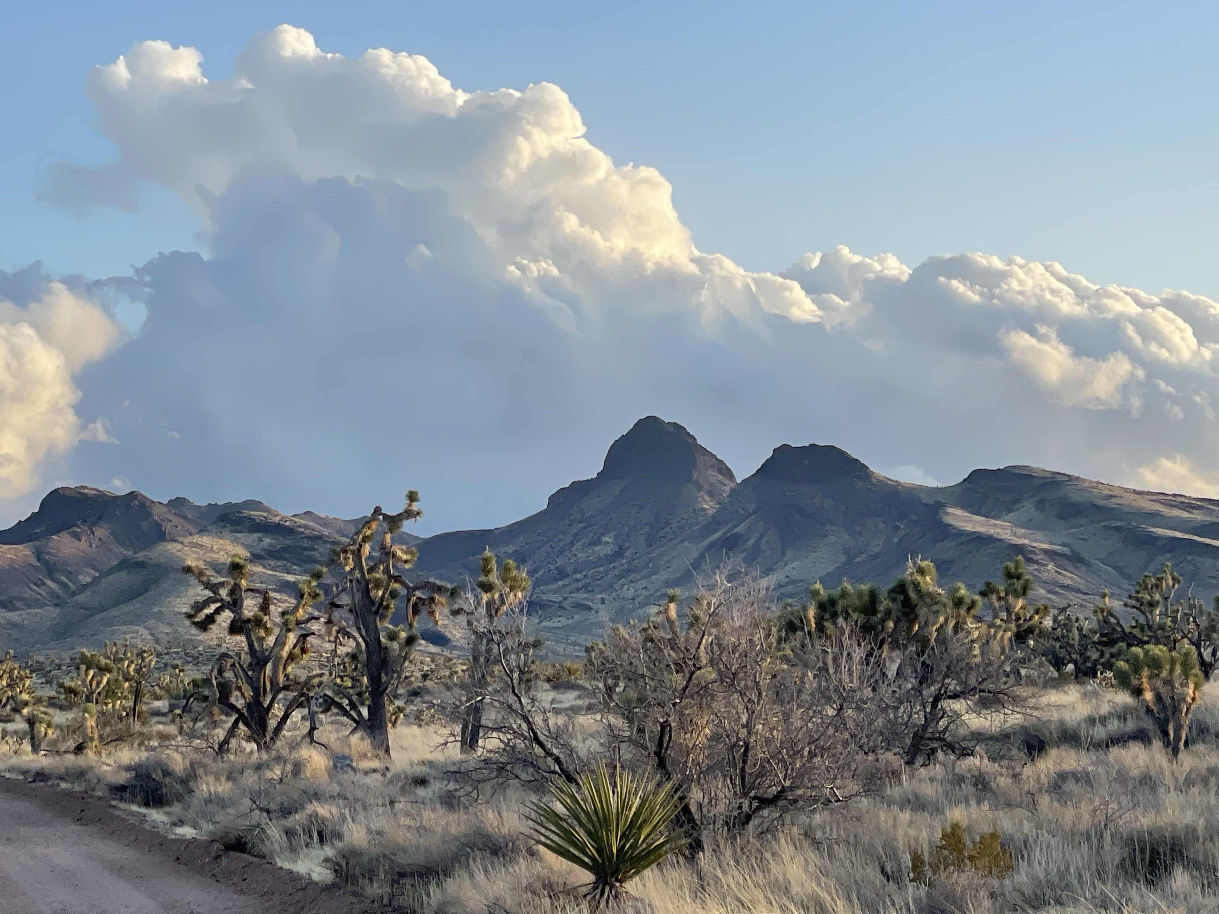
A few miles down, the route to Castle Mountains turns onto a dirt road and runs southwest toward the California border. It passes through a Joshua tree forest cooperatively managed between the BLM and the Nature Conservancy. Views of the Castle Mountains surrounded by Joshua trees and the Mojave Desert open up nicely just prior to the boundary.

BLM-Nature Conservancy land
Nevada, USA

BLM-Nature Conservancy land
Nevada, USA

Mojave Desert with clouds from atmospheric river
BLM-Nature Conservancy land
Nevada, USA

Mojave Desert with clouds from atmospheric river
BLM-Nature Conservancy land
Nevada, USA

Mojave Desert with clouds from atmospheric river
BLM-Nature Conservancy land
Nevada, USA
Castle Mountains National Monument

Castle Mountains National Monument
California-Nevada Border, USA
At the California border, the road – now primarily an access road to a mining inholding within the authorized monument boundary – crosses the authorized monument boundary, marked by a large sign. Technically the road itself is not part of the park, at least not yet. To actually enter the monument, you have to walk, drive, or bike up one of the side roads (please remember that the desert is very fragile, and do not just walk, drive, or bike off of designated roads or trails).

Castle Mountains National Monument
California-Nevada Border, USA

Castle Mountains National Monument
California-Nevada Border, USA

Castle Mountains National Monument
California, USA
On my first visit to Mojave National Preserve in 2017, we were advised that Castle Mountains wasn’t really intended for visitors, and it feels it – the roads are dirt, there are no interpretive services, and attempting to access any roads other than the main mine access road requires AWD or 4WD (depending on conditions) as well as at least medium clearance if going slowly, with high clearance preferred. Side roads have sufficient rocks in places such as drainage crossings. All terrain tires are crucial to avoid flats in that context.

Castle Mountains National Monument
California, USA
But here I am, and several miles down, I turn onto one of these side roads and do a short loop through the desert in the direct shadow of the mountains. Views of the Castle Crags, in Mojave National Preserve to the northwest, are also splendid. Upon accessing the main road again, I return the way that I came, but one could also possibly continue to the mining inholding, although I’m not sure if through access is possible on the main road.

Castle Mountains National Monument
California, USA

Castle Mountains National Monument
California, USA
Based on the map, it may be possible to bypass the inholding on one of the side roads, and join the main road again on the other side of the inholding, but I cannot say for sure. Again, and I cannot emphasize this enough, side roads require an AWD or 4WD SUV with at least medium clearance (going slowly). Entering from the California side one should expect similar conditions as one would find on the side roads. Those already on the fence about road conditions should enter from Nevada.


Castle Mountains National Monument
California, USA

Castle Mountains National Monument
California, USA
Things to Do
- Scenic drives through pristine Mojave desert scenery, fauna and flora
- Hiking, cycling, backcountry driving (all on unmaintained roads)
- Camping

Castle Mountains National Monument
California, USA
Suggested Itinerary
Enter via Walking Ranch Road off of NV-164 west of Searchlight and enjoy the views of the Mojave desert landscape and Castle Mountains in this park filling in a keyhole of Mojave National Preserve, in a sense. If you have medium (going slowly) or high clearance, as well as all terrain tires, you can drive one of the side roads into the monument itself. If not, stick to hiking or mountain biking them, or find a spot to pitch a tent along them for the night. You may encounter traffic on Walking Ranch/Hart Mine Road, especially leaving the mining inholding at the end of the workday, but you are unlikely to encounter anyone on the monument roads.

Castle Mountains National Monument
California, USA

Castle Mountains National Monument
California, USA

Castle Mountains National Monument
California, USA

Castle Mountains National Monument
California, USA


Castle Mountains National Monument
California, USA

Castle Mountains National Monument
California, USA


Castle Mountains National Monument
California, USA

Castle Mountains National Monument
California, USA

Castle Mountains National Monument
California, USA

Castle Mountains National Monument
California, USA

Castle Mountains National Monument
California, USA

Castle Mountains National Monument
California, USA

Castle Mountains National Monument
California, USA
Nearby Parks and other Federal Lands
Mojave National Preserve
This national park protects a diverse segment of the Mojave Desert and surrounds Castle Mountains on three sides. The distinctive (if confusing) Castle Crags (not to be confused with the Castle Mountains) are a prominent section of the New York Mountains within the preserve and can be viewed spectacularly within Castle Mountains NM.
Lake Mead National Recreation Area
A short drive east takes you to the Lake Mojave segment of Lake Mead NRA and its surrounding desert corridor. While Lake Mohave is a major attraction for boaters, there are also trails to other features in the desert, including petroglyph galleries; mountains sacred to indigenous tribes in the area; and more.
BLM Historic Route 66 Backcountry Byway
Running from Kingman to Topock, this original section of US-66, the Mother Road, crosses the Black Mountains of Northwest Arizona. It includes one of the most iconic mountain crossings on the entire road at Sitgreaves Pass. The segment is accessible via I-40 at Topock or via Bullhead City and south via AZ-95. For the latter, turn off US-95 on NV-163 at Palm Gardens and proceed to Laughlin, then cross into Arizona to meet AZ-95 in Bullhead.
Alternatively, if you have a car similarly equipped to handle the roads at Castle Mountains, you can turn off further north on US-95 onto Christmas Tree Pass, and take that through Lake Mead NRA to meet NV-163 closer to Laughlin. Regardless, two routes from AZ-95 connect to US-66: Boundary Cone Road, which links up just south of Oatman, or for the purist who wants to drive the full stretch, County Route 1 connects Mohave Valley to US-66 at Golden Shores.
Havasu National Wildlife Refuge
Nearly entirely wilderness, this area hosts 318 species of birds and surrounds or abuts the Colorado River in two segments: from I-40 south toward Lake Havasu City, and surrounding Topock Marsh on the east side of the river just north of I-40. The segment that surrounds Topock Gorge, often called a miniature Grand Canyon, is a designated Wilderness area. Lake Havasu City outfitters arrange boat, canoe and kayak tours, and there is a daily roundtrip boat connection between Laughlin and Lake Havasu City that takes you through the gorge (albeit focused more on transportation and less on the scenery). Foot access is difficult but possible from surrounding BLM land.
Sloan Canyon National Conservation Area
A BLM National Conservation Area designated by Congress in 2002, it protects the southern mountain skyline of Las Vegas and includes a petroglyph site featuring more than 300 panels. The North McCollough Wilderness area within Sloan Canyon contains examples of volcanic landscapes with lava flows, ash falls, and glassy zones. Remember that all archeological resources are protected by the Archeological Resources Protection Act and the Antiquities Act and are part of the shared heritage of all Americans.
Red Rock Canyon National Conservation Area
Designated by Congress in 1990, the popular Red Rock Canyon NCA features a 13 mile scenic drive, hiking trails, rock climbing, horseback riding, mountain biking, road biking, picnic areas, nature observing, and a visitor center. The spectacularly colored desert landscape here attracts millions of visitors annually from around the world, as it is located only miles from the Las Vegas Strip.
Jnana Hodson
What a wonderful, definitive, post! Helps me understand why my younger daughter and her husband so much wanted to camp in winter amid the Joshua trees before they left California, something that took three years to accomplish, due to Covid restrictions.
Aspen
Thanks! Yes, winter in the Mojave among the joshua trees can be magical. One of my favorite experiences was sunrise at Joshua Tree NP, when I woke up to one of the trees silhouetted against a colorful sunrise sky. It was pretty chilly (January) but I didn’t care – I jumped out of the tent and ran to the car to get my camera for a photo. That photo will feature on my Joshua Tree NP entry for sure, so make sure to stay tuned for that one!