Arizona Trail Passage 19: Superstition Wilderness
AZT Day 59
Trans-Arizona/Utah Day 66
In the land of Arizona
Through desert heat or snow
Winds a trail for folks to follow
From Utah to Old Mexico
It’s the Arizona Trail
A pathway through the great Southwest
A diverse track through wood and stone
Your spirit it will test
Oh, sure you’ll sweat and blister
You’ll feel the miles every day
You’ll shiver at the loneliness
Your feet and seat will pay
But you’ll see moonlight on the borderlands
You’ll see stars on the Mogollon
You’ll feel the warmth of winter sun
And be thrilled straight through to bone
The aches and pains will fade away
You’ll feel renewed and whole
You’ll never be the same again
With Arizona in your soul
Along the Arizona Trail
A reverence and peace you’ll know
Through deserts, canyons, and mountains
From Utah to Old Mexico
-“The Arizona Trail,” Dale R. Shewalter
Pine Creek to Reavis Ranch
Today begins with a journey through the Superstition Mountains, beneath towering orange-red cliffs of volcanic ash (technically I believe welded tuff) to Reavis Ranch. The trail ascends from Pine Creek to Reavis Gap to begin the day, then drops to the ranch and Reavis Creek. Throughout, the cliffs combine with the brilliant blue sky and green ironwood bushes, pinyon pines and juniper for a striking scene.

Arizona Trail, Passage 19 (Superstition Wilderness)
Tonto National Forest

Arizona Trail, Passage 19 (Superstition Wilderness)
Tonto National Forest


Arizona Trail, Passage 19 (Superstition Wilderness)
Tonto National Forest

Arizona Trail, Passage 19 (Superstition Wilderness)
Tonto National Forest

Arizona Trail, Passage 19 (Superstition Wilderness)
Tonto National Forest

Arizona Trail, Passage 19 (Superstition Wilderness)
Tonto National Forest

Arizona Trail, Passage 19 (Superstition Wilderness)
Tonto National Forest


Tonto National Forest

Arizona Trail, Passage 19 (Superstition Wilderness)
Tonto National Forest

Arizona Trail, Passage 19 (Superstition Wilderness)
Tonto National Forest

Arizona Trail, Passage 19 (Superstition Wilderness)
Tonto National Forest

Arizona Trail, Passage 19 (Superstition Wilderness)
Tonto National Forest

Arizona Trail, Passage 19 (Superstition Wilderness)
Tonto National Forest

Tonto National Forest
Reavis Ranch
Elisha Reavis founded the ranch and planted apple trees here along the creek that now bears his name.
I unfortunately don’t find any apples, which are said to still grow on the trees here, but I do run into a Canadian hiker, Matt, visiting the area on a hiking trip with his father. The two are doing separate hikes for the next 24-48 hours; Matt is planning on meeting him near Superior tomorrow, so hiking partners it is for the journey through Rogers and Reavis Canyons and out to Superior tomorrow.
Making it out to Superior by tomorrow night is a priority for both of us – the following 3 days are not looking good in terms of the forecast. With it also being Thanksgiving, I’m considering staying with a trail angel in Superior to wait out the weather (even though I’m usually to push through come what may.)
The following passage is notorious for being dry, so as an added bonus, any additional rain may help the rain-catching structure that the AZTA built on it recently fill up from the dry summer, perhaps continue to aid seasonal stream flow, and limit how much I have to carry.
For now, though, I enjoy the encounter with some of the largest trees I’ve ever seen outside of California, the Arizona sycamores that grow along Reavis Creek. It’s likely that these date to the era of the ranch or quite possibly earlier, just by looking at some of them.

Arizona Trail, Passage 19 (Superstition Wilderness)
Tonto National Forest

Arizona Trail, Passage 19 (Superstition Wilderness)
Tonto National Forest

Arizona Trail, Passage 19 (Superstition Wilderness)
Tonto National Forest

Tonto National Forest


Arizona Trail, Passage 19 (Superstition Wilderness)
Tonto National Forest

Arizona Trail, Passage 19 (Superstition Wilderness)
Tonto National Forest

Arizona Trail, Passage 19 (Superstition Wilderness)
Tonto National Forest


Arizona Trail, Passage 19 (Superstition Wilderness)
Tonto National Forest

Arizona Trail, Passage 19 (Superstition Wilderness)
Tonto National Forest

Arizona Trail, Passage 19 (Superstition Wilderness)
Tonto National Forest

Arizona Trail, Passage 19 (Superstition Wilderness)
Tonto National Forest

Arizona Trail, Passage 19 (Superstition Wilderness)
Tonto National Forest

Arizona Trail, Passage 19 (Superstition Wilderness)
Tonto National Forest
Arizona Trail: Reavis Ranch to Rogers Canyon
Departing Reavis Ranch, the trail follows Reavis Creek until the head of its drainage, then turns southwest and rolls along the mountains toward Rogers Canyon. The crossing unknowingly passes by Reavis’ grave, as it later turns out, which I will have to make a return trip to document. Given the scenery of the area, motivation for that should not be a challenge to assemble.

Arizona Trail, Passage 19 (Superstition Wilderness)
Tonto National Forest

Arizona Trail, Passage 19 (Superstition Wilderness)
Tonto National Forest

Arizona Trail, Passage 19 (Superstition Wilderness)
Tonto National Forest

Arizona Trail, Passage 19 (Superstition Wilderness)
Tonto National Forest

Arizona Trail, Passage 19 (Superstition Wilderness)
Tonto National Forest


Arizona Trail, Passage 19 (Superstition Wilderness)
Tonto National Forest

Arizona Trail, Passage 19 (Superstition Wilderness)
Tonto National Forest

Arizona Trail, Passage 19 (Superstition Wilderness)
Tonto National Forest

Arizona Trail, Passage 19 (Superstition Wilderness)
Tonto National Forest
Arizona Trail: Rogers Canyon to Rogers Trough Trailhead
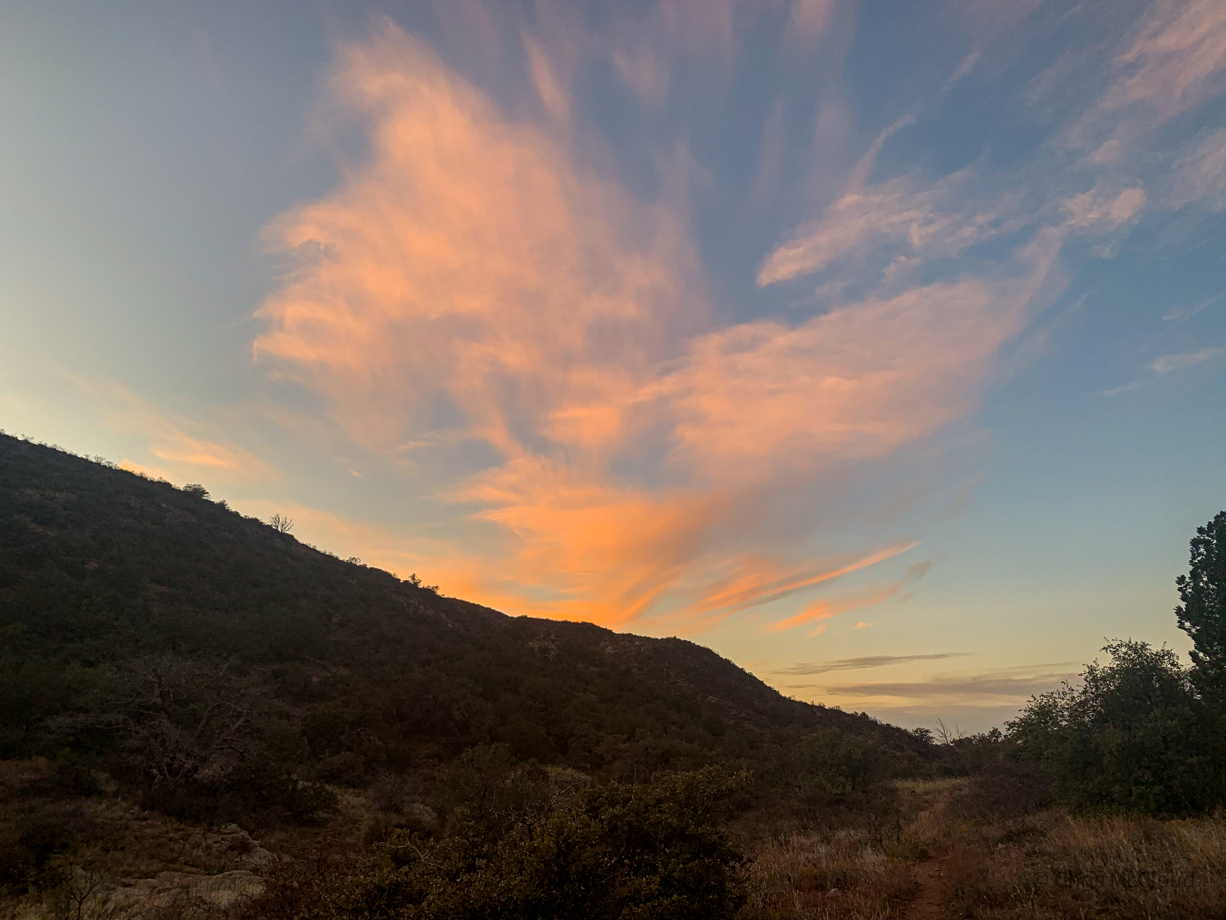
Reaching Rogers Canyon, the trail turns southward again and follows the canyon toward Rogers Trough Trailhead and Montana Mountain. I had hoped to make the mountain itself by the end of today, but Matt and I agree to hold off and do the final ascent in the morning, so we remain near the trailhead for the night. Sunset ignites the mountainsides and clouds with ribbons of color streaking across the sky. A fitting end to another day on the Arizona Trail, and to the Superstition Mountains passage.

Arizona Trail, Passage 19 (Superstition Wilderness)
Tonto National Forest

Arizona Trail, Passage 19 (Superstition Wilderness)
Tonto National Forest

Arizona Trail, Passage 19 (Superstition Wilderness)
Tonto National Forest

Arizona Trail, Passage 19 (Superstition Wilderness)
Tonto National Forest

Arizona Trail, Passage 19 (Superstition Wilderness)
Tonto National Forest

Arizona Trail, Passage 19 (Superstition Wilderness)
Tonto National Forest

Arizona Trail, Passage 19 (Superstition Wilderness)
Tonto National Forest
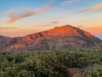
Arizona Trail: Superstitions Geology
Many of those who hike through this spectacular area have no idea they are walking through a supervolcano. A fair number of individuals are aware that the largest that currently exists is the Yellowstone Caldera. 50 miles wide, it has an explosive history that has blown a hole in the Rocky Mountains and altered the climate within its path.
The Superstitions were more like Yellowstone’s little brother. 25-15 million years ago, they erupted in three successive eruptive events. This produced the Superstition Cauldron, Goldfield Cauldron, and Tortilla Caldera. The former two are invisible today; the latter does show some surface features (hence the different terms used to refer to them). Collectively, they are known today officially as the Superstition-Goldfield Volcanic Zone or the Superstition Cauldron Complex.
While two of the three calderas no longer exhibit visible surface features, the mountains in the vicinity show plenty of evidence of the activity. Rhyolite rock and welded tuff, ash that was still so hot when it descended that it fused into a rock form, form dramatic cliffs that rise above the hillside and mountains, creating a ruggedly spectacular landscape. 2500 cubic miles of ash and lava were pumped out by the Superstitions in the life of their eruptions.
Stay tuned for my next AZT entry covering the climb to Montana Mountain and descent through Reavis Canyon to the AZT trail town of Superior. Reavis Canyon is well known for its rattlesnake population – will we spot any tomorrow?
If you missed my last post covering the second part of my crossing through the Superstition Mountains on the Arizona Trail, you can check it out here:
https://aspenstracks.com/amazing-spectacular-arizona-trail-cottonwood-creek-to-pine-creek/
Arizona Trail: Passage 19 Logistics
| Passage 19 (Superstition Wilderness) | |
| AZTA Passage Information | Passage 19 (Superstition Wilderness) |
| AZTA Passage Elevation Profile | Passage 19 Profile |
| AZTA Passage Map | Passage 19 Map |
| Trail Surface | Forest Road (dirt) Dirt singletrack |
| Length (Mi) | 29.4 |
| Season | September-May |
| Potential Water Sources | Trail Tank (mi 344.8 NB, 443.1 SB) Cottonwood Creek (Mi 342.9 NB, 445.0 SB) Cottonwood Spring (mm 339.2 NB, 448.7 SB) Walnut Spring (mi 329.1 NB, 458.8 SB) Pine Creek (mi 327.8 NB, 460.2 SB) Reavis Creek (mi 325.3 NB, 462.6 SB) Reavis Ranch (mi 324.9 NB, 463.1 SB) Reavis Creek (mm 324.1 NB, 463.8 SB) Reavis Saddle Spring (mm 321.7 NB, 466.2 SB) Rogers Spring (mm 318.2 NB, 469.7 SB) Current AZTA Water Reports: AZTA Water Reports |
| Trailheads | North: Vineyard Trailhead South: Rogers Trough Trailhead |
| Trailhead Access | North: Vehicular access; via paved road South: Vehicular access via graded dirt road |
| Wilderness | Yes, most |
| Possible resupply points | Roosevelt Lake Marina (north end) Farther, Globe and Tonto Basin |
| ATA-Rated Difficulty | Strenuous |
| Potential campsites (mileages S to N) | Beware flash floods in the Cottonwood Creek drainage Cottonwood Creek Basin Walnut Spring Pine Creek Reavis Ranch-Reavis Creek area |
| Ecosystems Traversed | Arizona Upland |
| Highlights | Views of Four Peaks, Tonto Basin & Roosevelt Lake Volcanic history of the Superstition Mountains Desert flora & fauna diversity Far fewer people than west side of Superstitions |
3 thoughts on “Amazing, Spectacular Arizona Trail: Pine Creek-Rogers Trough”