Arizona Trail Approach, Day 3
Vermilion Cliffs National Monument

Backpacking Paria Canyon-Vermilion Cliffs Wilderness
Vermilion Cliffs National Monument
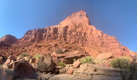
First Spring-Wingate Formation
Slow start this morning as I continue to hiking up Paria Canyon through the Paria Canyon-Vermilion Cliffs Wilderness area within Vermilion Cliffs National Monument. The spring that I reached on yesterday’s backpacking leg, the first on the trail, is little more than a trickle, and I have a lot of water to fill. It marks the border between the Chinle Formation and the Wingate Sandstone.

Hiking Paria Canyon-Vermilion Cliffs Wilderness
Vermilion Cliffs National Monument

Paria Canyon-Vermilion Cliffs Wilderness, Vermilion Cliffs National Monument
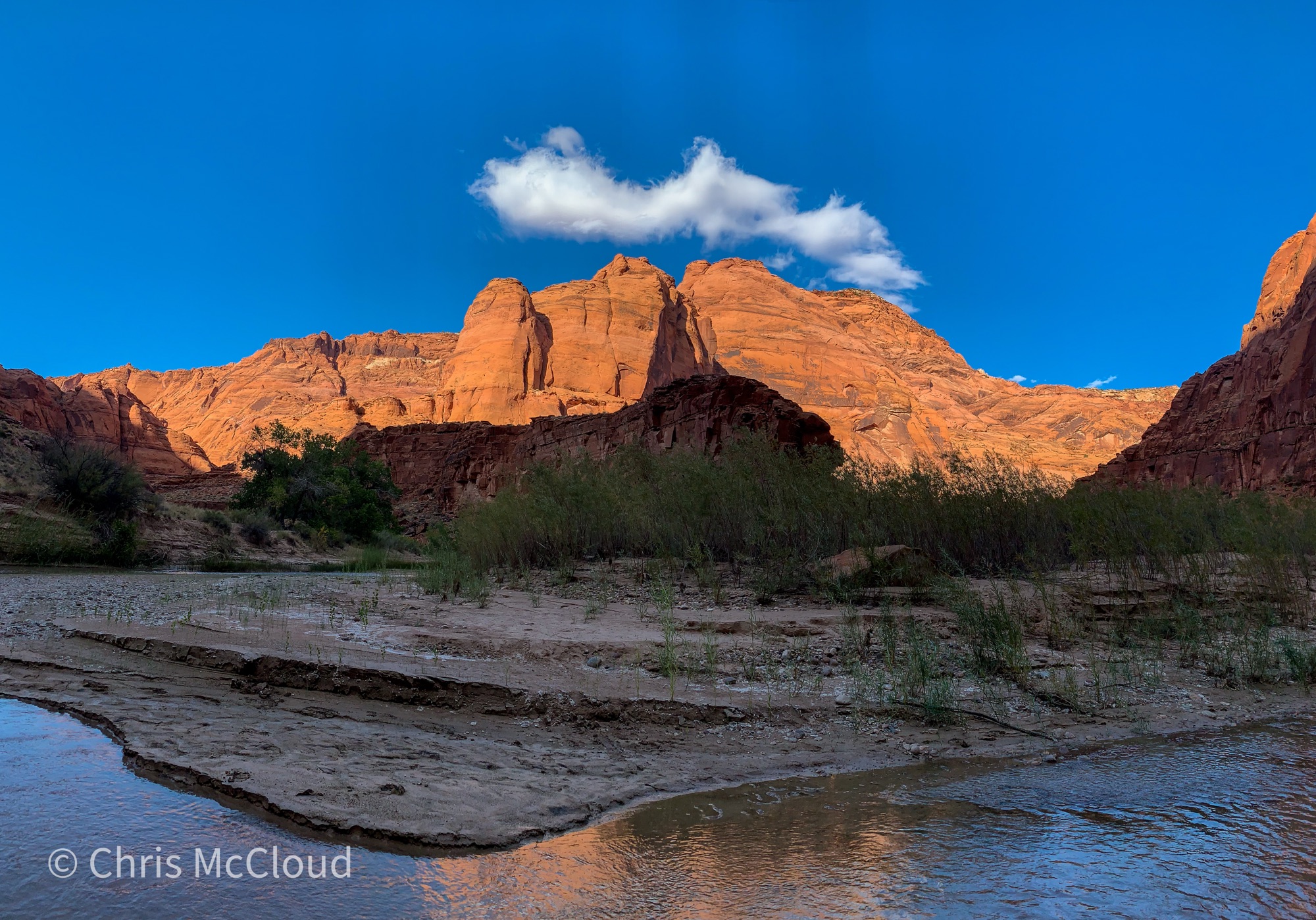
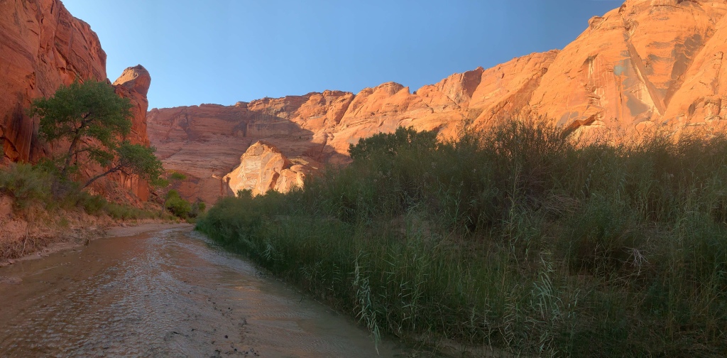
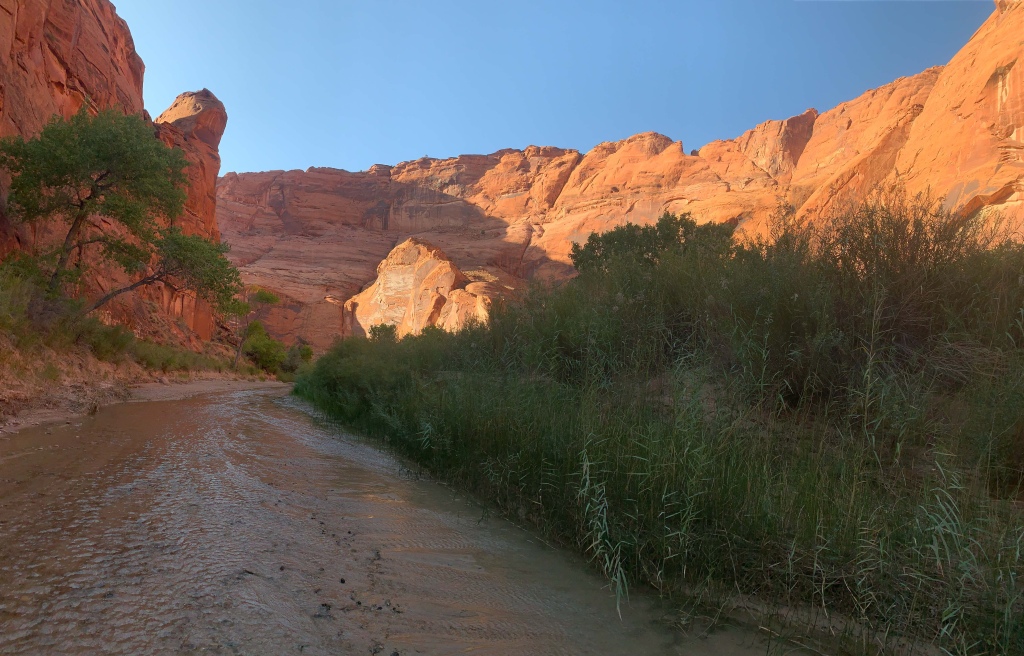
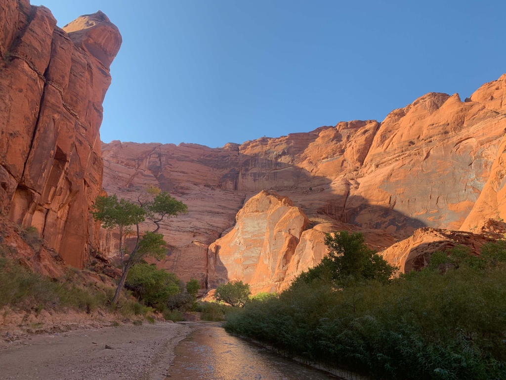
As I begin to wind my way further up Paria Canyon, deeper and deeper into the wilderness, the gorgeous weather and cool breeze continues.
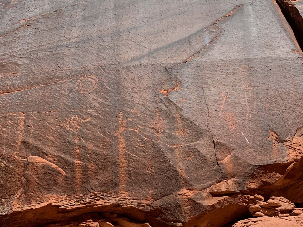
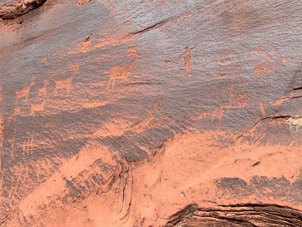
Paria Canyon: Wingate Formation-Petroglyph Galley-Kayenta Formation
Continuing through the Wingate Formation, I pass a great gallery of petroglyphs, one of the largest I’ve ever seen. Every time I thought that I’d documented all of them I spotted more and had to go back up again. Just incredible. Canyon perils exist, too – I narrowly avoided injuring myself trying to (successfully) avoid stepping on a canyon tree frog. But after doing my program on those this summer at Grand Canyon, I couldn’t harm one here.

Hiking Paria Canyon-Vermilion Cliffs Wilderness
Vermilion Cliffs National Monument
Paria Canyon-Vermilion Cliffs Wilderness, Vermilion Cliffs National Monument

Paria Canyon-Vermilion Cliffs Wilderness, Vermilion Cliffs National Monument

Paria Canyon-Vermilion Cliffs Wilderness, Vermilion Cliffs National Monument

Paria Canyon-Vermilion Cliffs Wilderness, Vermilion Cliffs National Monument
Paria Canyon-Vermilion Cliffs Wilderness, Vermilion Cliffs National Monument

Paria Canyon-Vermilion Cliffs Wilderness
Vermilion Cliffs National Monument

Paria Canyon-Vermilion Cliffs Wilderness
Vermilion Cliffs National Monument

Paria Canyon-Vermilion Cliffs Wilderness
Vermilion Cliffs National Monument

Paria Canyon-Vermilion Cliffs Wilderness
Vermilion Cliffs National Monument

Paria Canyon-Vermilion Cliffs Wilderness
Vermilion Cliffs National Monument
Paria Canyon: Kayenta Formation-Wrather Canyon
As the canyon rises, the Wingate Formation gives way to the Kayenta Formation and the canyon enters a wider and more heavily vegetated stretch, where sediment has clearly been both deposited and eroded by severe flash flooding – the vegetation growing is evidence of the amount of water provided by the river and the thick rich silt it has deposited, but the current river channel is also in places feet below the level of the vegetation, with a bank that just drops off, evidence of the power of the floods that can sweep through here.
But not today, thankfully.

Paria Canyon-Vermilion Cliffs Wilderness
Vermilion Cliffs National Monument

Paria Canyon-Vermilion Cliffs Wilderness
Vermilion Cliffs National Monument

Paria Canyon-Vermilion Cliffs Wilderness
Vermilion Cliffs National Monument

Paria Canyon-Vermilion Cliffs Wilderness
Vermilion Cliffs National Monument

Vermilion Cliffs National Monument

Vermilion Cliffs National Monument
Paria Canyon-Vermilion Cliffs Wilderness
Vermilion Cliffs National Monument

Paria Canyon-Vermilion Cliffs Wilderness
Vermilion Cliffs National Monument

Paria Canyon-Vermilion Cliffs Wilderness
Vermilion Cliffs National Monument

Paria Canyon-Vermilion Cliffs Wilderness
Vermilion Cliffs National Monument

Paria Canyon-Vermilion Cliffs Wilderness
Vermilion Cliffs National Monument

Paria Canyon-Vermilion Cliffs Wilderness
Vermilion Cliffs National Monument

Paria Canyon-Vermilion Cliffs Wilderness
Vermilion Cliffs National Monument
Paria Canyon: Kayenta Formation Transition-Wrather Canyon
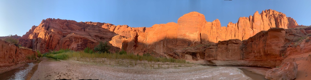
I ultimately make it to just above Wrather Arch – a cave-type arch in Wrather Canyon. Beautiful regardless of the technical terminology involved. Hopefully I have time to hit it quickly in the morning before continuing upcanyon. The red rock is simply magnificent as it glows in the evening light.

Paria Canyon-Vermilion Cliffs Wilderness
Vermilion Cliffs National Monument
Paria Canyon-Vermilion Cliffs Wilderness
Vermilion Cliffs National Monument
Paria Canyon-Vermilion Cliffs Wilderness
Vermilion Cliffs National Monument
Paria Canyon-Vermilion Cliffs Wilderness
Vermilion Cliffs National Monument

Paria Canyon-Vermilion Cliffs Wilderness
Vermilion Cliffs National Monument

Paria Canyon-Vermilion Cliffs Wilderness
Vermilion Cliffs National Monument
Paria Canyon-Vermilion Cliffs Wilderness
Vermilion Cliffs National Monument

Paria Canyon-Vermilion Cliffs Wilderness
Vermilion Cliffs National Monument

Paria Canyon-Vermilion Cliffs Wilderness
Vermilion Cliffs National Monument

Paria Canyon-Vermilion Cliffs Wilderness
Vermilion Cliffs National Monument

Paria Canyon-Vermilion Cliffs Wilderness
Vermilion Cliffs National Monument
Note: all images in this post, as well as additional ones unposted, are available for sale as prints. Please message me on one of the linked social media feeds if interested! Don’t forget to subscribe and follow if you enjoy these accounts!
.
Paria Canyon-Vermilion Cliffs Wilderness Logistics
| Paria Canyon-Vermilion Cliffs Wilderness | |
| BLM Information | Paria Canyon-Vermilion Cliffs Wilderness |
| Weather Forecast | Buckskin Gulch Weather |
| Trail Surface | Rustic (the river is the trail) |
| Length (Mi) | 45 (Lee’s Ferry to Wire Pass via Buckskin Gulch) 38 (Paria Canyon, Lee’s Ferry to White House) 20 (Wire Pass to White House via Buckskin Gulch) 22, approx. (Buckskin Gulch to White House) 1.8 (Wire Pass to Buckskin Gulch) |
| Season | Fall-Spring. Brutally hot in summer. |
| Potential Water Sources | Springs. Unless informed otherwise by a BLM ranger, there is likely no drinkable water in Buckskin Gulch, and the Paria River should be considered undrinkable even when filtered. Know how to recognize desert springs. |
| Trailheads | Paria Canyon North: White House Paria Canyon South: Lee’s Ferry Buckskin Gulch Middle Exit Buckskin Gulch West Wire Pass |
| Trailhead Access | Vehicular access to all trailheads |
| Wilderness | Yes |
| Possible resupply points | None |
| Difficulty | Strenuous |
| Potential campsites | Best near springs. Some higher-water campsites in north, south of Buckskin Gulch-Paria Canyon confluence. Use higher water sites if there is any risk of rain. Few to no campsites in Buckskin Gulch. |
| Threats | Flash flooding – Extreme hazard here. Know the forecast daily (an inReach or other satellite communicator helps with this). Know how to recognize the signs of a flash flood and how to react. You cannot outrun a flash flood; you must climb above it. This is not possible in Buckskin Gulch – do not enter it if storms are in the forecast during your trip. Heat – wear a cotton shirt so you can soak it. Synthetics aren’t great in the desert. Hyponatremia – “drunk on water.” To avoid, ensure adequate salt & electrolyte intake and ensure you eat as well as drink water. Symptoms are almost identical to dehydration, but drinking more makes it worse. Prevention is by far the best solution. Dehydration Hypothermia in winter, made worse by exposure to cold water Because there is no trail, there are places where boulders must be climbed around or over and at least one spot where your pack must be hauled over a boulder jab. Flash floods change the trail, shifting obstacles around, removing some and adding others. Expect the unexpected. |
| Permits Required? | Yes. 20 people max per night issued on recreation.gov . |
| Miscellaneous | Leave No Trace is different in the desert. Know desert principles and carry wag bags. |
| Cell service? | Nonexistent |