AZT Passage 16: Gila River Canyons
Arizona Trail Day 64, Part 2
Trans-Arizona/Utah Day 72, Part 2
Welcome back to Aspen’s Tracks, thruhiking the Arizona Trail southbound from Utah to Mexico. Today’s route covers backpacking the stretch of Passage 16, the Gila River Canyons, between the northern AZT passage boundary at the Tonto National Forest’s southern edge to my first night’s camp on the passage at the Gila River. You can find today’s hiking logistics below the photo documentation and trail journal of the route.
If you missed my last entry covering the leg through the prior segment of the Gila River Canyons, that can be found here. The next entry will cover the continued journey along the Gila toward the crossing at the Kelvin-Riverside Bridge. If you enjoy these accounts, please do subscribe to follow along to make sure that you don’t miss out on here or any future accounts to come!
(Note: the photos herein are smaller and at 50% quality, however, full quality ones are available to those interested, please contact me separately if so. This change was made to speed page loading but if you would prefer the full quality images please leave a comment to let me know).
In the land of Arizona
“The Arizona Trail,” Dale R Shewalter
Through desert heat or snow
Winds a trail for folks to follow
From Utah to Old Mexico
It’s the Arizona Trail
A pathway through the great Southwest
A diverse track through wood and stone
Your spirit it will test
Some will push and pedal
And some will hike or run
Others will ride their horse or mule
What else could be more fun?
Oh, sure you’ll sweat and blister
You’ll feel the miles each day
You’ll shiver at the loneliness
Your feet and seat will pay
But you’ll see moonlight on the borderlands
You’ll see stars on the Mogollon
You’ll feel the warmth of winter sun
And be thrilled straight through to bone
The aches and pains will fade away
You’ll feel renewed and whole
You’ll never be the same again
With Arizona in your soul
Along the Arizona Trail
A reverence and peace you’ll know
Through deserts, canyons, and mountains
From Utah to Old Mexico
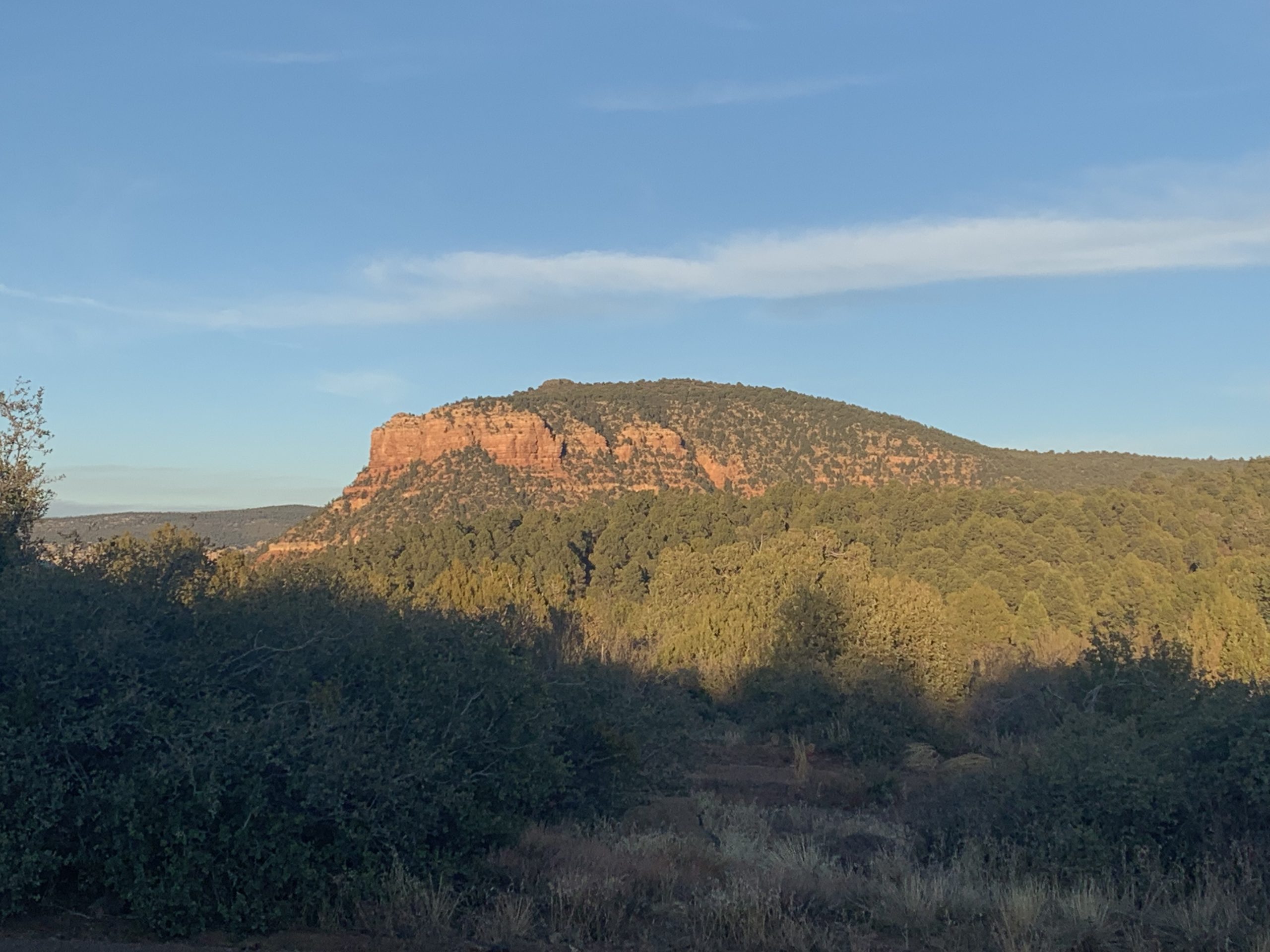
Arizona Trail: Martinez Canyon Overlook-Dale’s Butte
Cresting the pass after the overlook into Martinez Canyon reveals a spectacular view to the south. Numerous mountains can be seen stretching into the distance across the Gila Valley. The rocks seem to increase in color, and rugged ridgelines soar overhead, carved by wind and water over countless millennia.

Arizona Trail, Passage 16 (Gila River Canyons)

Arizona Trail, Passage 16 (Gila River Canyons)

Arizona Trail, Passage 16 (Gila River Canyons)

Arizona Trail, Passage 16 (Gila River Canyons)

Arizona Trail, Passage 16 (Gila River Canyons)
The trail descends to the Gila through a chain of canyons and drainages and past rugged peaks, Saguaros, and buttes. Views to the south stretch into the distance under the crystal blue Arizona sky. Prominent among these is an officially unnamed one trail users have started calling “Dale’s Butte” after Dale Shewalter, the “father of the AZT.” Ocotillo are blooming after the big storm that hit a few days ago as well, yet more evidence of the profound impact that rain in the desert can have on its inhabitants.

Arizona Trail, Passage 16 (Gila River Canyons)

Arizona Trail, Passage 16 (Gila River Canyons)

Arizona Trail, Passage 16 (Gila River Canyons)

Arizona Trail, Passage 16 (Gila River Canyons)

Arizona Trail, Passage 16 (Gila River Canyons)
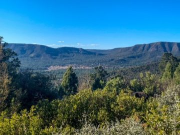
Arizona Trail: Dale’s Butte-AZT Low Point
I stop partway down to soak in the view across and eastward along the Gila River Valley. As the trail descends, more views and angles on Dale’s Butte as well as many other outcrops and elements of the rugged landscape emerge. It’s all just absolutely spectacular. This is prime Gila monster territory, too, so I’m keeping my eyes peeled, but don’t see any today.

Arizona Trail, Passage 16 (Gila River Canyons)

Arizona Trail, Passage 16 (Gila River Canyons)


Arizona Trail, Passage 16 (Gila River Canyons)

Arizona Trail, Passage 16 (Gila River Canyons)

Arizona Trail, Passage 16 (Gila River Canyons)
AZT Low Point-Gila River Camp
Upon reaching the Gila, the trail encounters a floodplain forest, including mesquite, Fremont cottonwoods, willows and more. This marks the lowest point on the entire Arizona Trail, the culmination of over two months of rolling descent (in aggregate). The trail makes a hard east turn and begins to roll along the Gila River to the east, marking the beginning of the second major defining section of the passage. Mining shafts are present as it starts to roll along the River. I ultimately find a campsite and settle in for the night.

Arizona Trail, Passage 16 (Gila River Canyons)

Arizona Trail, Passage 16 (Gila River Canyons)

Arizona Trail, Passage 16 (Gila River Canyons)

Arizona Trail, Passage 16 (Gila River Canyons)

Arizona Trail, Passage 16 (Gila River Canyons)

Arizona Trail, Passage 16 (Gila River Canyons)


Arizona Trail, Passage 16 (Gila River Canyons)

Arizona Trail, Passage 16 (Gila River Canyons)

Arizona Trail, Passage 16 (Gila River Canyons)

Arizona Trail, Passage 16 (Gila River Canyons)

Arizona Trail, Passage 16 (Gila River Canyons)

Arizona Trail, Passage 16 (Gila River Canyons)

Arizona Trail, Passage 16 (Gila River Canyons)

Arizona Trail, Passage 16 (Gila River Canyons)

Arizona Trail, Passage 16 (Gila River Canyons)

Arizona Trail, Passage 16 (Gila River Canyons)

Arizona Trail, Passage 16 (Gila River Canyons)

Arizona Trail, Passage 16 (Gila River Canyons)

Arizona Trail, Passage 16 (Gila River Canyons)

Arizona Trail, Passage 16 (Gila River Canyons)

Arizona Trail, Passage 16 (Gila River Canyons)

Arizona Trail, Passage 16 (Gila River Canyons)

Arizona Trail, Passage 16 (Gila River Canyons)
Passage 16 Logistics
| Passage 16 (Gila River Canyons) | |
| AZTA Page and Map | Passage 16 (Gila River Canyons) Passage 16 Map Passage 16 Elevation Profile |
| Weather | Passage 16 Weather |
| Trail Surface | Dirt Singletrack |
| Length (Mi) | 25.7 |
| Season | September-May |
| Potential Water Sources | Gila River is unreliable and must be prefiltered and/or settled when flowing. Walnut Canyon may have water. Full sources & Current Status: Arizona Trail Water Sources |
| Trailheads | North: Tonto National Forest boundary South: Kelvin-Riverside Bridge |
| Trailhead Access | North: No vehicular access South: Vehicular access via paved road |
| Wilderness | No |
| Possible resupply points | Superior (north end) Kearny (south end, requires roadwalk or hitch) |
| ATA-Rated Difficulty | Difficult |
| Potential campsites | Terrain is pretty dry and rugged, but there are numerous campsites along the section paralleling the Gila River. |
| Ecosystems Traversed | Arizona Upland, mostly Riparian along the Gila River |
| Highlights | Rugged canyon scenery Gila River Walnut Canyon Wildlife |
| Dog friendly? | Yes |
| Bike friendly? | Yes |
| Hazards | One of driest passage on trail. Gila River is unreliable and must be prefiltered and/or settled when flowing. Walnut Canyon may have water. Extreme Heat in summer Flash flooding during monsoon (July-September) |
Passage 16 Ecology
| Arizona Upland | Riparian | |
| Common Trees/Shrubs | * Fairy duster * Blue and littleleaf palo verde * Fremont wolfberry * Graythorn * Ocotillo * Red barberry * Scrub-live oak * Snapdragon-penstemon * Turpentine bush * Velvet mesquite * Whitethron acacia | * Fremont Cottonwood * Tamarisk/salt cedar (invasive) * Goodding’s willow |
| Common herbaceous plants | * California flannelbush [rare in Arizona, Superstition Mountains included] * Bluedicks * Brittlebush * California poppies * Creamcups * Desert chicory * Desert rockpea * Desert windflower * Fringed red maids * Globemallows * Lupines * Sego-lily | |
| Common succulents | * Arizona pencil cholla * Banana yucca * Soaptree yucca * Buckhorn cholla * Cane cholla * Chainfruit * Hedgehog cactus * Pencil cholla * Pincushion cactus * Prickly pears * Saguaro * Teddybear cholla |
דירות דיסקרטיות בטבריה
I want to to thank you for this very good read!! I certainly enjoyed every little bit of it. I have got you book-marked to check out new stuff you postÖ