AZT Backpacking: Passage 20 (Four Peaks)
Arizona Trail Day 55
Trans-Arizona/Utah Day 62
Welcome back to Aspen’s Tracks, thruhiking the Arizona Trail southbound from Utah to Mexico. Today’s entry covers backpacking the first stretch of Passage 20, the Four Peaks.
In the land of Arizona
Through desert heat or snow
Winds a trail for folks to follow
From Utah to Old Mexico
It’s the Arizona Trail
A pathway through the great Southwest
A diverse track through wood and stone
Your spirit it will test
Oh, sure you’ll sweat and blister
You’ll feel the miles every day
You’ll shiver at the loneliness
Your feet and seat will pay
But you’ll see moonlight on the borderlands
You’ll see stars on the Mogollon
You’ll feel the warmth of winter sun
And be thrilled straight through to bone
The aches and pains will fade away
You’ll feel renewed and whole
You’ll never be the same again
With Arizona in your soul
Along the Arizona Trail
A reverence and peace you’ll know
Through deserts, canyons, and mountains
From Utah to Old Mexico
-“The Arizona Trail,” Dale R. Shewalter
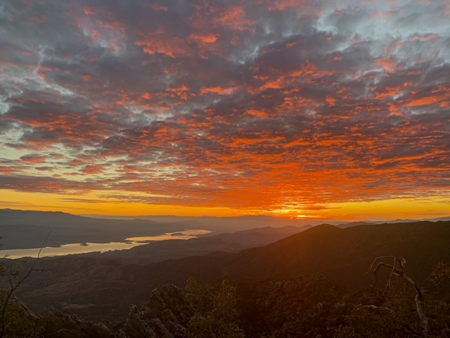
Day 55 on the Arizona Trail. I spent the morning on job applications for next summer, my highest priority region in the Pacific Northwest/Alaska. I still managed to get a few miles of backpacking in today beneath the incredible Four Peaks. The terrain is incredibly precipitous – in places the trail seems to occupy the only level ground around. Fire impacts are present throughout as well – a legacy of the 1996 Lone Fire.
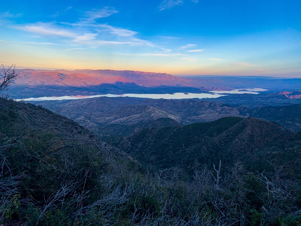
Two campers left a campfire smouldering in 1996 near Lone Pine Saddle without extinguishing it properly. Hundred year old pine trees were burned. For 11 days, the fire burned, consuming much of the Four Peaks Wilderness, greatly changing its characteristic experience from one focused on the old growth forest to one centered on, say, the views provided of the Peaks, Mazatzals, and Roosevelt Lake within Tonto Basin. Ultimately over 61,000 acres burned – then the largest fire in Arizona history. More recently, the Bush Fire in June 2020, another anthropogenic (human caused) fire, began at the intersection of Bush Hwy and AZ-87, going on to consume 193,455 acres, and hold the dubious distinction of being the largest fire actively burning in the US.
Along the Arizona Trail: Lone Pine Fire
Two campers left a campfire smouldering in 1996 near Lone Pine Saddle without extinguishing it properly. Hundred year old pine trees were burned. For 11 days, the fire burned, consuming much of the Four Peaks Wilderness, greatly changing its characteristic experience from one focused on the old growth forest to one centered on, say, the views provided of the Peaks, Mazatzals, and Roosevelt Lake within Tonto Basin. Ultimately over 61,000 acres burned – then the largest fire in Arizona history. More recently, the Bush Fire in June 2020, another anthropogenic (human caused) fire, began at the intersection of Bush Hwy and AZ-87, going on to consume 193,455 acres, and hold the dubious distinction of being the largest fire actively burning in the US.
(If you missed my description of the Mazatzal Mountains, you can find that as well as logistics and ecology reports for the passage after the photos. You can also read more about my time hiking through them elsewhere here, including here for the Red Hills and here for the Barnhardt Trail off the Mazatzal Divide, as well as here and here for portions of the central Mazatzals.

Arizona Trail, Passage 20 (Four Peaks)
Four Peaks Wilderness
Tonto National Forest

Arizona Trail, Passage 20 (Four Peaks)
Four Peaks Wilderness
Tonto National Forest

Arizona Trail, Passage 20 (Four Peaks)
Four Peaks Wilderness
Tonto National Forest

Arizona Trail, Passage 20 (Four Peaks)
Four Peaks Wilderness
Tonto National Forest

Arizona Trail, Passage 20 (Four Peaks)
Four Peaks Wilderness
Tonto National Forest

Arizona Trail, Passage 20 (Four Peaks)
Four Peaks Wilderness
Tonto National Forest
Arizona Trail, Passage 20 (Four Peaks)
Four Peaks Wilderness
Tonto National Forest
Arizona Trail, Passage 20 (Four Peaks)
Four Peaks Wilderness
Tonto National Forest

Arizona Trail, Passage 20 (Four Peaks)
Four Peaks Wilderness
Tonto National Forest

Arizona Trail, Passage 20 (Four Peaks)
Four Peaks Wilderness
Tonto National Forest
Mazatzal Mountain Geology
The Mazatzal Mountains themselves are an incredible place. The origin of the name “Mazatzal” is unclear, though one possible meaning is a Nahuatl term meaning “place of the deer.”
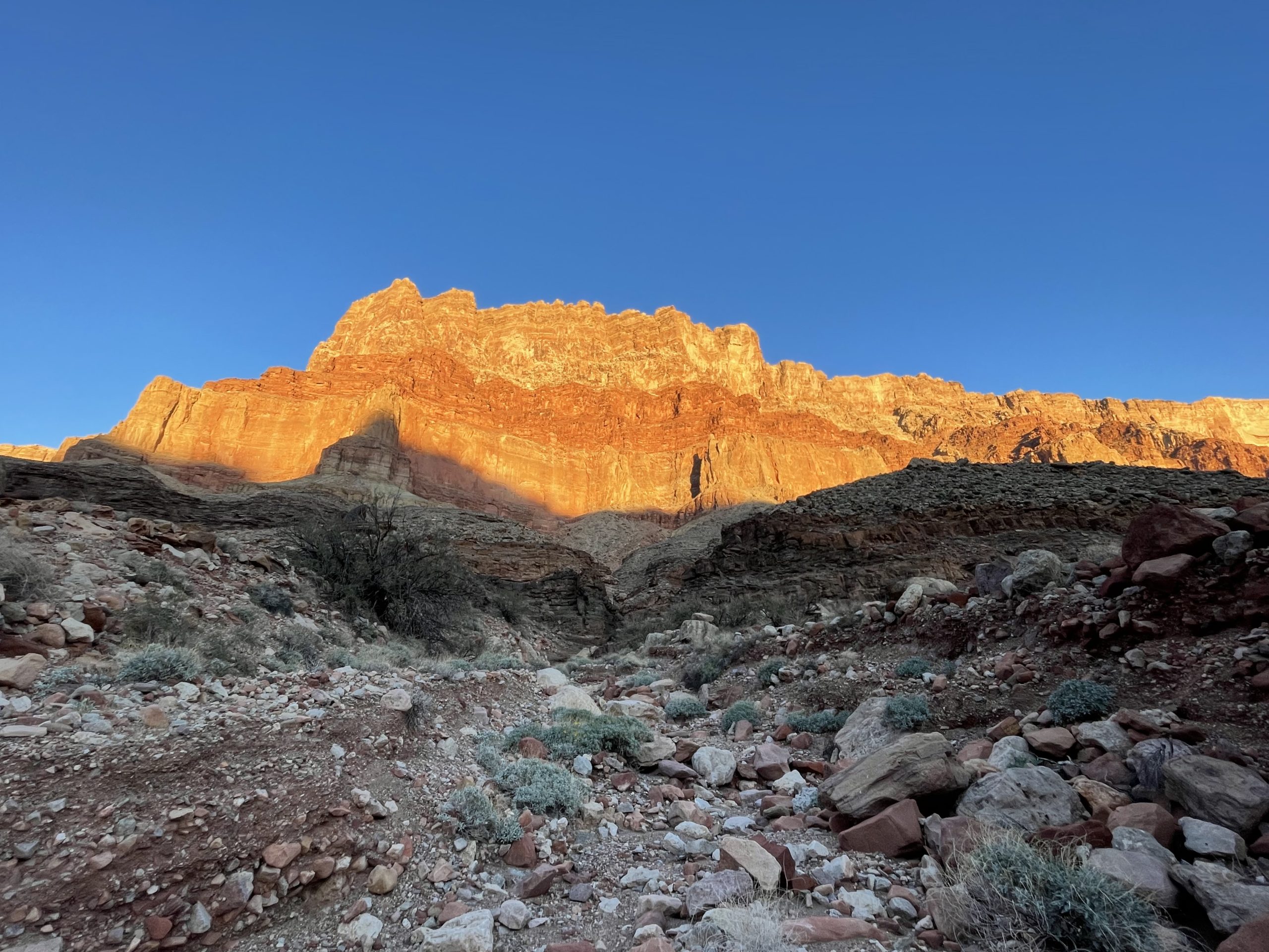
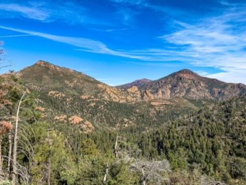
Formed during an orogeny (a term referring to the process that creates mountains) when Arizona was a coastal region on the margin of what became North America, the Mazatzals gained their rugged nature as tectonic collisions compressed rock, lifting it and thrusting it above other rocks (overthrust). The Four Peaks, the highest points of the Mazatzals, tower above the Arizona Trail with a jagged face that makes it appear as though half the mountain was simply cut away.
As the name suggests, there are indeed four Peaks – Amethyst Peak, Sister Peak, Brother Peak, and Brown’s Peak, in increasing elevation. Brown’s is the highest point in the Mazatzals and Maricopa County, while Amethyst hosts the only commercial amethyst mine in the United States. This passage passes through the southern half of the full Mazatzal range.
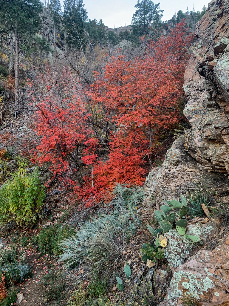
Unfortunately the area was greatly impacted by the Lone & Bush Fires, which burned much (though not all, as we will see) of the old ponderosa forest that had made the mountains one of the most popular long-distance stretches of the Arizona Trail.
Yet the incredible geology, solitude, sunsets, and views remain for the hardy and prepared souls who venture into this special place. Bagworms spin magnificent webs here, and temperatures are relatively tolerable outside of winter, when snow can make stretches impassable for those without adequate preparation.
Arizona Trail: Passage 20 Trail Logistics & Passage Ecology
Passage Map: Passage 20 (Four Peaks)
| Passage 20 (Four Peaks) | |
| Trail Surface | Dirt singletrack |
| Length (Mi) | 19 |
| Land Manager and Contact Info | US Forest Service; Tonto National Forest – Home (usda.gov) |
| Season | March-May, September-November |
| Potential Water Sources | Pigeon Spring (Mi 421.6 NB, 421.6 SB) Bear Spring (mi 400.6 NB, 422.5 SB) Shake Spring (mi 392.5 NB, 423.4 SB) Granite Spring (mi 391.5 NB, 431.3 SB) Buckhorn Creek (mi 390.5 NB, 432.9 SB) |
| Trailheads | North: Lone Pine Saddle South: Theodore Roosevelt Lake |
| Trailhead Access | North: Vehicular access; via graded dirt road South: Vehicular access (parking at Roosevelt Lake Marina) |
| Wilderness | Yes |
| Possible resupply points | Phoenix (north end) Roosevelt Lake Marina (south end) Farther, Globe and Tonto Basin |
| ATA-Rated Difficulty | Strenuous |
| Potential campsites (mileages S to N) | Precipitous terrain limits options, but there are some spots around Mills Ridge Trailhead & the Chillicut Trail junction |
| Ecosystems Traversed | Arizona Upland Interior Chaparral Great Basin Conifer Woodland Relict Conifer Woodland |
| Highlights | Four Peaks Views of Tonto Basin & Roosevelt Lake SOBO, first saguaro appearance on trail |
| Interior Chaparral | Great Basin Conifer Woodland | Rocky Mountain Montane Conifer Woodland | |
| Common Trees/Shrubs | * Birchleaf Mahogany * Ceanothus * Holly-leaf buckthorn * Manzanita * Shrub live oak * Silktassels * Stansbury cliffrose | * Arizona alder * Holly-leaf buckthorn * Junipers * Oaks, including Arizona oak, canyon live oak, Emory oak, Gambel oak, scrub-live oak * Piñon pine * Red barberry * Serviceberry * Silktassels * Skunkbush * sugar sumac | * Ponderosa Pine * Southwestern white pine * Subalpine fir * White fir * Rocky Mountain maple * Bigtooth maple * Grey alder * Red birch * Red osier dogwood * Cliffbush * Mallow ninebark * New Mexican locust * huckleberry * bilberries |
| Common herbaceous plants | * Buckwheats * Globemallows * Lupines * Penstemons * Sego-lily * Wormwood | * fringed brome * Geyer’s sedge/elk sedge * Ross’ sedge * Bronze sedge/dry land sedge/hillside sedge/hay sedge/Fernald’s hay sedge * screwleaf muhly * bluebunch wheatgrass * Spruce-fir fleabane * wild strawberry/Virginia strawberry * Small-flowered woodrush * mountain sweet Cicely * bittercress ragwort * western meadow-rue * Fendler’s meadow-rue | |
| Common succulents | * Agaves – golden flowered, Parry’s, Toumey’s * Banana & soap tree yucca * Barrel cactus * beargrass * beehive cactus * buckhorn cholla * Cane Cholla * hedgehog cacti * prickly pear cacti * Rock echeveria * Sotol * Whipple’s cholla | * beehive cactus * Claret cup hedgehog cacti * Golden-flowered agave * Parry’s agave * Prickly pear cacti * Whipple cholla * Tonto Basin agave |

xlcrgirl
Awesome coverage nature’s wonder