
Among the mesas and valleys of western New Mexico, a road travels. Above it, a wall of rock rises, reaching out toward the road. El Morro, ”the headland.” For thousands of years, humans have been passing by this landmark of the Southwest, drawn by its natural water pool that retains water in some quantity year round. Indigenous peoples, Spanish explorers, and American settlers have all interacted with this landscape. Over two thousand people have signed their names on the rock. Several indigenous pueblos can be found here, and during an active monsoon, wildflowers explode across the fields surrounding El Morro National Monument.

El Morro National Monument
New Mexico
Recommended Time
2-4 hours allows you to view the park film and exhibits and take a leisurely walk on both trails.
Things to Do at El Morro
- Hiking
- One paved, accessible trail
- One rustic trail
- Exhibits
- Park Film
History
El Morro has evolved a great deal over the years. Indigenous Pueblo peoples resided here from the 13th-14th centuries, then moved west to what is now the Zuni Nation in the early 15th century. In the 16th century, the Spanish arrived, finding that only the Hopi and Zuni towns remained west of the Continental Divide. Puebloans primarily resided in the Rio Grande watershed, though they traded with rural tribes such as the Apache, Ute, Paiutes, and Havasupai, whose precise distribution in that period isn’t well established.
The Spanish had heard stories of gold-filled cities; Don Juan de Onate, the first Spaniard to carve his name on El Morro, did so while exploring the modern Southwest including the Pacific Ocean and Gulf of California in search of such places. He and other Spaniards were sometimes met with hostility and sometimes friendship. Peoples such as the Acoma resisted the Spanish incursion; the Spanish responded by “killing hundreds and destroying Acoma Pueblo. Many…were captured and given severe punishment, but they eventually returned and rebuilt their homes.”
As elsewhere in the southwest, Franciscan priests came to the area to serve the dual purpose of seeking to convert the population to Christianity and to establish loyalty to the Spanish crown. They recruited indigenous peoples to “build mission churches and to join the Spaniards in wars against unconquered tribes.” At the same time, they ”taught new skills and tried to shield the Indians from harsh government practices. Submitting to Spanish power, the Pueblos found the new domestic animals and food plants desirable and the church ritual good, but were confused and dismayed to be punished for practicing their own religion.”
The efforts to shield the population from government practices eventually weakened Spanish control and encouraged thoughts of freedom. The Puebloans revolted in 1680 and the Spaniards retreated to the south; for 12 years the area was again controlled by the Pueblos. However, the unity waned. Don Diego de Vargas led a Spanish army back into New Mexico in 1692, leading to Spanish control over the area yet again.
In 1821, the area passed to the new Republic of Mexico, then to the United States in 1848 following the Mexican War. US Army expeditions were dispatched to map the region and deal with the free tribes. The first English carvings (seen in the pictures below) were from two soldiers with one such expedition, returning from a treaty with the Navajo in 1849.
Beale’s Trail was mapped through the area by Edward Beale’s mapping expedition in 1857. Beale took 25 camels along with him, but eventually the mule won out in the competition for draft animal in the Southwest. In mapping the route, Beale followed the old native and Spanish route past El Morro, bringing many people past the location in the years to come and adding further names to the rock.
Campaigns continued against the indigenous population; traversing the region continued to have risk. The Navajo, Apache and others continued to resist US control of the area. The Navajo eventually surrendered in 1864 and signed a final treaty in 1868 allowing them to return to northeast Arizona after significant suffering in exile at Fort Sumner in eastern New Mexico. The Apache continued to resist but eventually lost their struggle as well. Meanwhile, El Morro was eventually bypassed by the railroad farther north, and eventually by US-66 and I-40 as well, greatly reducing the number of people who pass by. Today, it almost feels like you must be heading to either Zuni, El Morro, or El Malpais to be on the road that passes by, and it is somewhat hard to imagine that it was once the primary route to California.
In 1906, Congress passed the Antiquities Act, enabling the president to establish National Monuments on land already publicly owned. President Theodore Roosevelt soon proclaimed El Morro National Monument as one of the first in the country. Today, it stands as a monument to all of the peoples who have passed the site, drawn by its perennial pool and shaded trees, wildflowers, views, and inscriptions, all combining into the story of El Morro.
Hiking at El Morro
Walking is essential to seeing the resources at El Morro. El Morro has two main trails, the Inscription Rock Trail and the Headland Trail. They overlap on the lower segment (i.e. one could see the Headland Trail as an extension of the Inscription Rock Trail). The Inscription Rock Trail is 0.5 miles and fully accessible.
The Headland Trail exits the Inscription Rock Trail at the tip of El Morro where the latter loops back to the Visitor Center, and continues with a natural surface. It climbs to the summit of El Morro and passes by the final stops in the park interpretive guide. It then passes two native pueblos on the summit, one unexcavated and one currently being excavated and provides stunning views of the surrounding Ramah Valley.
Inscription Rock Trail
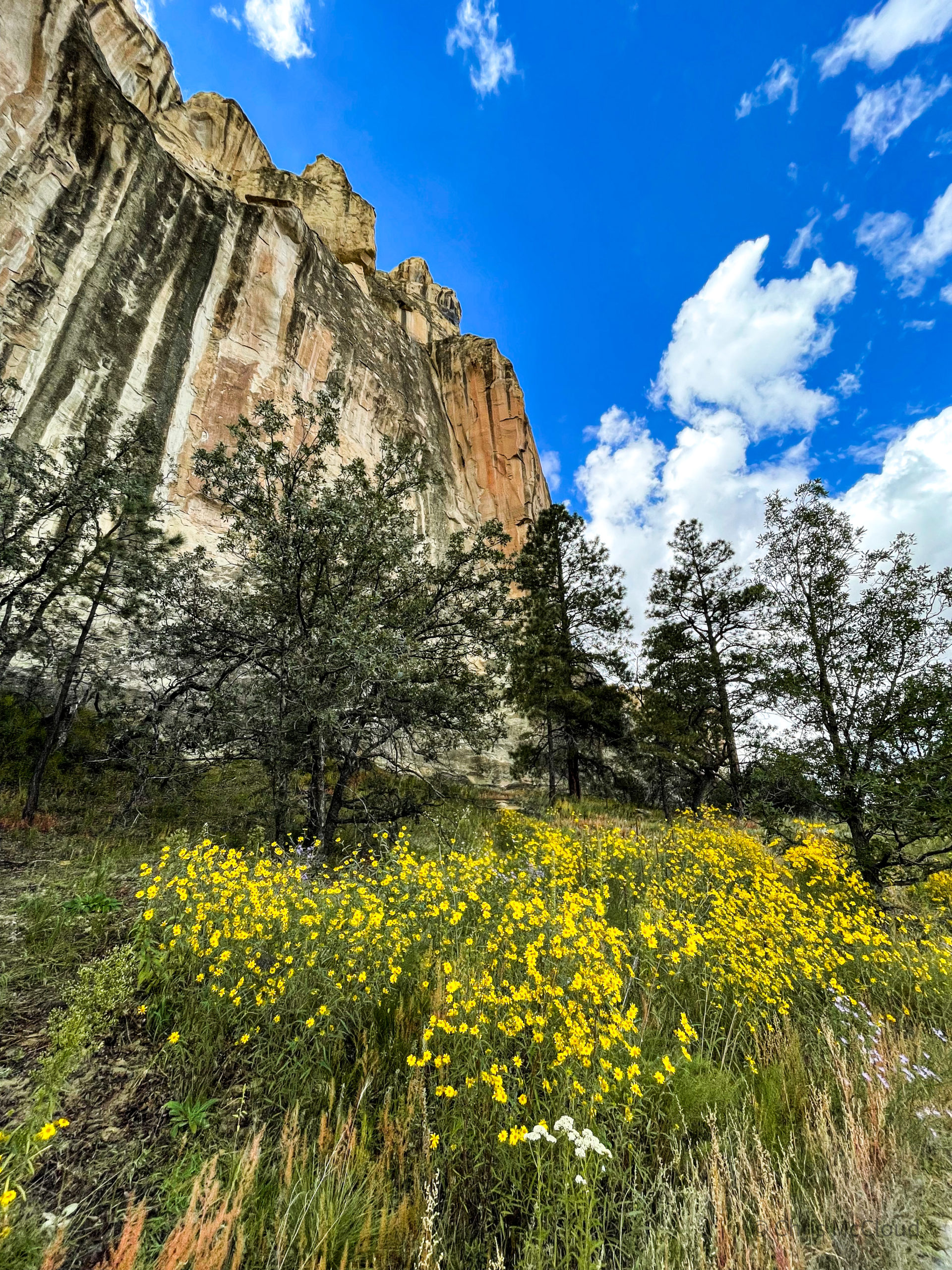
The Inscription Rock Trail begins immediately behind the visitor center and ascends a short slope to the base of El Morro before turning toward the feature that originally drew people to this site, without which it would not be the historical resource it is today. Views of the mesa towering above under a likely brilliant blue sky are incredible, and in late summer during an active monsoon the trail may be lined with wildflowers, as was the case for me.


El Morro National Monument
New Mexico
While we often think of parks as ”living museums,” the landscape at El Morro shows a major change pretty quickly. The piñon-juniper forest all around is a product of fire suppression and grazing. At the time the pueblos peaked, this was high desert grassland, with rabbitbrush and saltbush.

El Morro National Monument
New Mexico

El Morro National Monument
New Mexico


What originally drew people to El Morro was a perennial pool of water that collects on the east side, the ”Oasis.” Shaded from evaporation by the sun, the pool fills in the spring from snowmelt and in summer during active monsoons. Seeing as the journey from Albuquerque to Zuni took 9-10 days before interstates and cars came along, this pool of water was a crucial source on the way across the southwest. It has been somewhat enhanced by a dam constructed across the outlet as well, but when full it holds about 200,000 gallons of water in a pool about 12 feet deep. It made both a good source of water for the indigenous people who constructed pueblos in the area and travelers passing by who went on to inscribe the rock. The Spanish referred to it as “El Estanque del Peñol,” or, ”the pool by the great rock.” Unsurprisingly, since this was the attraction for people to the site, this is also the point at which inscriptions begin to appear on the rock.

El Morro National Monument
New Mexico


El Morro National Monument
New Mexico

El Morro National Monument
New Mexico

El Morro National Monument
New Mexico

El Morro National Monument
New Mexico
Stop 5’s guide reads that ”both women and men passed by El Morro, but very few women left their inscriptions. Miss A.F. Baley was one of the exceptions. America Frances Baley and her sister Amelia were part of a wagon party headed from Missouri to California in 1858. The group followed the route newly surveyed by the US Army and at the time known as Beale’s Wagon Road, which passed by El Morro.
If America Baley had known what she would encounter later in the journey she may not have continued. Just east of the Colorado River, eight hundred Mojave Indians attacked the sixty Anglo travelers. The Mojave killed nine and injured seventeen while suffering eighty-seven casualties themselves. The pioneering caravan retreated to New Mexico to wait out the winter in Albuquerque or Santa Fe. The Baley sisters eventually made it to Fresno County, California.”

El Morro National Monument
New Mexico

El Morro National Monument
New Mexico


El Morro National Monument
New Mexico

El Morro National Monument
New Mexico

El Morro National Monument
New Mexico
Stop 7, from the interpretive guide from the park: ”E. Penn Long, of Baltimore, Maryland, chiseled this elegant-looking inscription. Long was a member of a US Army expedition led by Lt. Edward F. Beale to find a wagon route from Fort Smith, Arkansas, to the Colorado River. The group, which first passed by El Morro in 1857, was also testing the usefulness of camels in crossing the deserts of the Southwest.
Though Beale wrote positively about the camels in his journals, the Army abandoned the experiment at the onset of the Civil War. Long and two other members of Beale’s group probably made their inscriptions during a second visit to El Morro in 1859. ’Mr Engle’ is in block print and ‘Mr Bryn’ in script. Engle was Beale’s second-in-command.”

El Morro National Monument
New Mexico
Stop 8, ”P. (Peachy) [Gilmer] Breckinridge was the man in charge of the twenty-five camels used by Lieutenant Beale in 1857. After his work with Beale, Breckinridge returned to his home state of Virginia and fought in the Civil War. He was killed during a skirmish at Kennon’s Landing, Virginia in 1863.”

El Morro National Monument
New Mexico

El Morro National Monument
New Mexico

El Morro National Monument
New Mexico
Stop 9, ”Many Spanish inscribers wrote ‘paso por aqui’ or ’passed through here.’ In Spanish, the inscription [in the box] reads ’A 25 del mes de Junyo, año de 1709 paso por aqui para Suni – Ramon Garcia Jurado’ or ‘On the 25th of the month of June, of this year of 1709, Ramon Garcia Jurado passed through here on the way to Zuni.’
From the time Ramon Garcia Jurado moved to New Mexico as a colonist in 1693 until his death at the age of 80 in 1760, he was witness and participant in the Spanish settlement of New Mexico. It is likely that he was on a campaign against the Navajos during his visit to El Morro in 1709.
To the right of Garcia Jurado’s inscription is a blackened inscription which translated reads, ‘Pedro Romero passed through here on the 2nd of August, year of 1751.’ These inscriptions are examples of early well-intentioned but intrusive attempts at preservation work. Early park managers darkened the inscriptions with graphite…so that they would be more visible and last longer. They ended this kind of preservation in the 1930s.”


El Morro National Monument
New Mexico
Stop 10. ”The last inscription from Spanish colonial times is by Andres Romero. He wrote, ’Andres Romero passed through here in the year 1774.’ Romero’s visit was followed by turbulent times. Mexico gained independence from Spain in 1821. Then, following the US-Mexican War from 1846-1848, the Treaty of Guadalupe Hidalgo ceded large areas of land from Mexico to the United States. This new land, the New Mexico Territory, opened the way for the Americans – the last of the inscribers – to come through El Morro.”

El Morro National Monument
New Mexico
Other clear inscriptions continue to be visible as the trail follows the face of the cliff.

El Morro National Monument
New Mexico
Stop 11, ”Notice the petroglyphs, particularly the bighorn sheep and the bear paw. Many petroglyphs depict animals that were once familiar fauna in the region. Their compelling shapes and actions invite us to pause and imagine why people may have pecked them into the bluff.
The Spanish inscription above the bighorn sheep petroglyphs reads: ‘Pasamos por aqui Sarjento mayor y el Capitan Ju[an] de Arechuleta y el aiudante diego martin barba y el alferes Augustin de ynojos año de 1636,’ or ’We, Sergant Major and Captain Juan de Arechuleta and Adjutant Diego Martin Barba and Ensign Agustin de Ynojos, passed by here, in the year of 1636.’
The ‘Sergeant Major’ was not an enlisted man as now – he was an officer in direct command of troops. The ensign was the standard bearer. Arechuleta was among the first colonists to come to New Mexico with Don Juan de Oñate in 1598. Arechuleta and Martin Barba were implicated in a plot to assassinate the colonial governor and were beheaded on Santa Fe’s plaza in 1643.”

El Morro National Monument
New Mexico
Stop 12, ”One of the oldest and more famous inscriptions at El Morro – that of the first governor of New Mexico, Don Juan de Oñate – was inscribed in 1605, 15 years before the Pilgrims landed at Plymouth Rock. In 1604, Oñate left the settlement of San Gabriel with thirty men in search of ’the South Sea’ (the Pacific Ocean).
During their trip, the group visited the Gulf of California as well as the South Sea. On his return, Oñate left this inscription: ’Paso por aq[ui] el adelantado Don Ju[an] de Oñate del descubrimyento de la mar del sur a 16 de Abril de 1605,’ or ’Governor Don Juan de Oñate passed through here, from the discovery of the Sea of the South on the 16th of April, 1605.’
The inscription was not made on Oñate’s first visit to El Morro – on December 13, 1598, he passed here from Zuni with a group of Spanish settlers, traveling to the Rio Grande via Acoma.
Below the Oñate inscription is an inscription that reads: ’Por aqui pazo de Alferes Don Joseph de Payba Basconzelos el ano que trujo el Cabildo del Reyno a su costa a 18 de febo de 1726 Anos’ or ‘The Ensign Don Joseph de Payba Basconzelos passed through here on the 18th of February 1726, the year he returned, at his own expense, the members of the cabildo to the kingdom [of New Mexico]. Basconzelos, a cabildo (council) member, paid for expelled council members to return to Santa Fe from Mexico City after a 3.5 year banishment by New Mexico’s governor.

El Morro National Monument
New Mexico

El Morro National Monument
New Mexico
Stop 13, ”R.H. Orton is just one of many inscriptions along the cliff here. You can see a church, some stars, crosses, petroglyphs and a cavalry flag. R.H. Orton became adjutant general of California after the Civil War. In the early years of the Civil War, the California Column, as it was known, was sent to New Mexico to reinforce Federal troops expecting Confederate hostilities. Orton held the rank of captain when the First Cavalry was mustered out from March to October of 1866. He may have made his inscription as he returned to California.


El Morro National Monument
New Mexico
Stop 14, “The high inscription names a frontier governor whose [name] is well known in New Mexico. ’Aqui estubo el Gen[era]l D[o]n D[ieg]o de Varg[a]s, q[uie]n Conquisto a n[eust]ra S[ant]a Fe y a la R[ea]l Corona todo el Nuebo Mexico a su costa, Año de 1692’ or ’General Don Diego de Vargas, who conquered for our Holy Faith and for the Royal Crown, all of New Mexico, at his own expense, was here, in the year of 1692.’
In 1680, the Pueblo Indians revolted against their conquerers. Many Spanish men, women and children were killed and the remainder fled to El Paso. In 1692, newly appointed governor of New Mexico, Don Diego de Vargas reestablished Spanish control of the pueblos. After the end of his first term as governor, he was imprisoned for three years in the governor’s palace for alleged wrongdoings among the settlers. He was exonerated and restored as governor for a second term in 1702. He died in Bernalillo in 1704 at the age of 61.
More than 150 years later, below Vargas’ inscription, three men added their own inscriptions. P.H. Williamson, Isaac Holland, and John Udell were members of the first emigrant train to try this route to California in 1858. The original caravan consisted of forty familiies and was led by LJ Rose, who was born in Germany but made his fortune in dry goods in Iowa. At El Morro, they left their inscriptions and then moved on to the Colorado River, where they were attacked by Mojave Indians.
Thanks to journals kept by the immigrants, we know that survivors of the attack, including Rose, the Baley sisters, and Udell and his wife who were both in their 60s, walked most of the way back to New Mexico to wait out the winter. Some of the party started again for California in 1859 in the company of Lt Edward F. Beale.


El Morro National Monument
New Mexico
Stop 15 is one where I couldn’t find the inscription, one by Sallie Fox. The park guidebook reads that ”Sallie Fox was twelve years old when she traveled with the Rose emigrant caravan. Though everyone called her ‘Sallie,’ she inscribed her proper name, ‘Sarah Fox.’ Sallie was shot with an arrow during the attack at the Colorado River, but she survived.

El Morro National Monument
New Mexico
Stop 16 features some railroad inscriptions: ”Imagine a steam engine streaming along in place of the road. In 1868, the Union Pacific Railroad ran a survey through here, but the project was never carried out. Some of the high carvings here have the initials ‘UPR’ carved by workers on the survey crew. The Santa Fe Railroad 25 miles to the north rerouted travelers, ending El Morro’s place as a stopover on the route west. Imagine if the railroad had come through here. Would the Interstate now pass by El Morro?”


El Morro National Monument
New Mexico

El Morro National Monument
New Mexico

El Morro National Monument
New Mexico

El Morro National Monument
New Mexico

El Morro National Monument
New Mexico

El Morro National Monument
New Mexico

El Morro National Monument
New Mexico

El Morro National Monument
New Mexico

El Morro National Monument
New Mexico
Stop 17, ”Another inscriber marked his passage by El Morro with this: ’In the year 1716 on the 26th of August don Feliz Martinez, Governor and Captain General of this Kingdom, and the reverend Father Antonio Camargo, Custodian and Ecclesiastical Judge, passed by here to the conventionists and conquest of the Moqui (Hopi).’
After leaving the inscription, Governor Martinez – an interim governor – found the Hopi unwilling to accept Spanish domination. After two months of quarreling, the expedition returned to Santa Fe. When the time came for Martinez to relinquish the office of governor, he refused until pressed by adversaries. Martinez died in Mexico City in 1731, leaving a large debt.


El Morro National Monument
New Mexico
Stop 18, ”The person memorialized by an inscription may not have been the person who did the inscribing. Here could be an example of just such a case. Because they were carved on the same day and seemingly in the same handwriting, we presume this inscription and the one to the west were inscribed by the same man.
The first one says, ‘The 28th day of September of 1737, Licentiate (Bachiller) Don Juan Ignacio of Arrasain arrived here.’ The second reads, ‘The 28th day of September of 1737, the illustrious lord Don Martin de Elizacochea, Bishop of Durango, arrived here, and the day following went to Zuni.’ The event records one of the first visits to this territory by a bishop from Durango, Mexico.”

El Morro National Monument
New Mexico

El Morro National Monument
New Mexico
Stop 19, ”The only poem on the rock reads,
‘Aqui [llego el Señor] y Gobernador
Don Francisco Manuel de Silva Nieto
Que lo imposible tiene ya subjeto
Su braço indubitable y su balor
Con los carros del Rey Nuestro Señor
Cosa Que solo el puso en este efecto
De Agosto 5 [Mil] Seiscientos Veinte Nueve
Que se Bien a Zuñi pasa y la Fe lleve’
or, in prose,
‘The Lord and Governor Don Fransisco Manuel de Silva Nieto came this far with out Lord King’s wagons. With his indubitable arm and valor, he has already overcome the impossible, a thing which he alone accomplished 5 August 1629 so that one may well proceed to Zuni and carry the Holy Faith.’
Governor Manuel de Silva Nieto was a knight of the Order of Alcantara. He was appointed governor in 1628 and served from 1629 to 1632. Scholars differ on their opinion of Governor Silva Nieto. Some say he was fair and well-liked, while another uncovered a report that he was so disliked he was murdered by his own servant!”

El Morro National Monument
New Mexico
Stop 20, ”After El Morro was designated a national monument in 1906, early park managers tried to preserve and protect the inscriptions and petroglyphs in a variety of ways. One planted the yuccas you’ve seen growing along the trail to encourage visitors to keep a safe distance from the wall. Oils from human hands increase the rate of erosion on petroglyphs and inscriptions. In the 1920s, the first superintendent decided to erase any inscriptions added to the wall after 1906 because they were graffiti and unlawful. You can see the large smooth areas where inscriptions were removed here. Today, managers struggle with the dillemma of preserving inscriptions and petroglyphs while allowing nature to take its course. “


El Morro National Monument
New Mexico
Final stop of the interpretive tour, ”Here is a fun inscription that invites us to imagine what may have happened. The first two lines of the inscription read, ’The 14th day of July 1736, General Paez Hurtado, Inspector, passed by here.” Underneath, it reads, ”and in his company, Corporal Joseph Trujillo!” Perhaps Corporal Trujillo added his own inscription. History does not reveal what happened to him.”

El Morro National Monument
New Mexico
Headland Trail
Branching from the Inscription Rock Trail, the Headland Trail traces the base of El Morro to the southwest side, providing views of the surrounding mesas and, in an active monsoon, fields of flowers.

El Morro National Monument
New Mexico

El Morro National Monument
New Mexico

El Morro National Monument
New Mexico


El Morro National Monument
New Mexico

El Morro National Monument
New Mexico

El Morro National Monument
New Mexico

El Morro National Monument
New Mexico

El Morro National Monument
New Mexico


El Morro National Monument
New Mexico
Having rolled along the base for a bit, the trail passes the final couple interpretive spots from the Inscription Rock guide, then begins to switchback up the north face of El Morro, providing great views of the promontory at its very head and teasing the view from the top. I won’t say where, but it passes an unexcavated pueblo, then begins to traverse the rocky summit around the canyon that penetrates the headland from the southwest. Views across the Ramah Valley, of the valley itself as well as the surrounding mesas and mountains, are exceptional.

El Morro National Monument
New Mexico

El Morro National Monument
New Mexico


El Morro National Monument
New Mexico

El Morro National Monument
New Mexico

El Morro National Monument
New Mexico


El Morro National Monument
New Mexico

El Morro National Monument
New Mexico

El Morro National Monument
New Mexico

El Morro National Monument
New Mexico
Watch out up here during the monsoon; it was bright and sunny when I started, but when I reached the summit, it began to hail. The weather can change in a hurry, especially at elevation. Take a jacket! The trail passes on past the Atsinna pueblo, where if you’re lucky, you may be able to speak to the park archeologist, who is indigenous, about the history of the area. Atsinna pueblo contains 18 rooms and was occupied by ancestors of the modern Zuni from roughly 1275-1400. After departing the pueblo, the trail then descends back to the visitor center.

El Morro National Monument
New Mexico


El Morro National Monument
New Mexico

El Morro National Monument
New Mexico

El Morro National Monument
New Mexico

El Morro National Monument
New Mexico


El Morro National Monument
New Mexico

El Morro National Monument
New Mexico
El Morro is a National Monument! Many people wonder what the difference is between different designations of the National Park System. Learn more about this here:
Is One National Park Service Designation Better than Another?