

Grand Canyon National Park
Grand Canyon. Whether viewing from the North Rim, South Rim, or within it, Theodore Roosevelt’s immortal words seem to echo off the majestic stone walls:
The Grand Canyon fills me with awe. It is beyond comparison, beyond description…Arizona has a natural wonder which is in kind absolutely unparalleled throughout the rest of the world. I want to ask you to keep this great wonder of nature as it now is…[do not] mar the wonderful grandeur, the sublimity, the great loneliness and beauty of the canyon. My advice to you is to leave it as it is. You cannot improve on it. The ages have been at work on it, and man can only mar it….Keep it for your children, and your children’s children, as the one great sight which every American should see.
Theodore Roosevelt
Now you too may have decided to heed Teddy’s advice and come see Grand Canyon National Park, a place that represents every major American ecosystem between Mexico and Canada. Grand Canyon is definitely one of my happy places – I actually just returned from another 5 days there a couple days ago. I’ve done most trails on the South Rim and quite a few on the North as well, at this point.
Here we’ll talk about a brief overview of the park, cover some of the must-dos, and go over a sample itinerary, and talk about some of the more immersive opportunities. We’ll also go into some of the things you should be aware of when visiting, all from the perspective of someone who used to work there.

Grand Canyon National Park
The first decision you need to make is which rim you want to go to. Here we will cover the South Rim, but I strongly recommend reading up on the North Rim as well before deciding whether to do one (and if so, which) or both. The South Rim is the iconic side. 90% of visitors go to the South Rim; it is far more crowded but also holds more of the iconic views. The North Rim, in my opinion, has more solitude, is a more authentic park experience, and has several of the best views in the entire park.
Getting to & Lodging On the South Rim of Grand Canyon
There are two main entrances; the East from the town of Cameron and South from Tusayan (and by extension, Flagstaff or Williams.) Most tourist facilities are located here. Within the park are four lodges: Maswick, Yavapai, El Tovar, and Bright Angel. There’s a grocery store, concession tours, bike rentals, and campground. There are more lodging and food options in the town of Tusayan, Arizona outside the South Entrance. There’s also a small lodging option in the town of Cameron outside the East Entrance.
Grand Canyon Hike Planning and Safety
The second decision you need to make is on how much hiking you plan on doing. The sample itinerary here assumes a half day hike. If you plan on more, keep that in mind and adjust your schedule accordingly. Know, too, that hiking into the Inner Canyon between 10-4 from May-September is inadvisable. Temperatures in the shade can exceed 120°F. Sun adds a further 10° and radiant heating another 10°, so you can experience temperatures of 140°.
At these temperatures, knowledge of proper thermoregulation techniques, salty snacks and electrolytes are all crucial merely to survive. Even if you do survive, attempting an extended hike during the peak of the day at this time will negatively impact your experience, whether you realize it or not.
You might also have heard the adage that “cotton kills;” this is true in humid and mountainous environments but not in the desert summer. If it is summer, wear cotton in the desert so that you can soak it and keep it wet – and you cool – for longer periods. Synthetics will dry faster, forcing you to use more water to stay cool and leaving you less to drink. Unlike many other places in the country, in the desert, cotton might literally save your life.
For more information on hiking safely at Grand Canyon, check out the park’s Hike Smart! tips on their website.

Grand Canyon National Park
Grand Canyon: South Rim Itinerary
Ok. If you are just doing the South Rim you’ll need at least two days. The South Rim gets very crowded from March-October. This fact should be paramount in your mind when planning. Double the time it would normally take to do things, and do the most crowded things early or late before crowds arrive and after they depart.
If coming during peak season, I strongly recommend staying in the park. You’ll avoid waiting in potentially long lines at the entrance, wasted time searching for parking, or getting up super early to avoid the prior two. (It’s about an hour and a half from Flagstaff and an hour from Williams to the canyon, and about 20 min from Tusayan without gate traffic). Ok, all that said, let’s get into the itinerary for a two day stay on the South Rim.
Grand Canyon (South Rim), Day 1
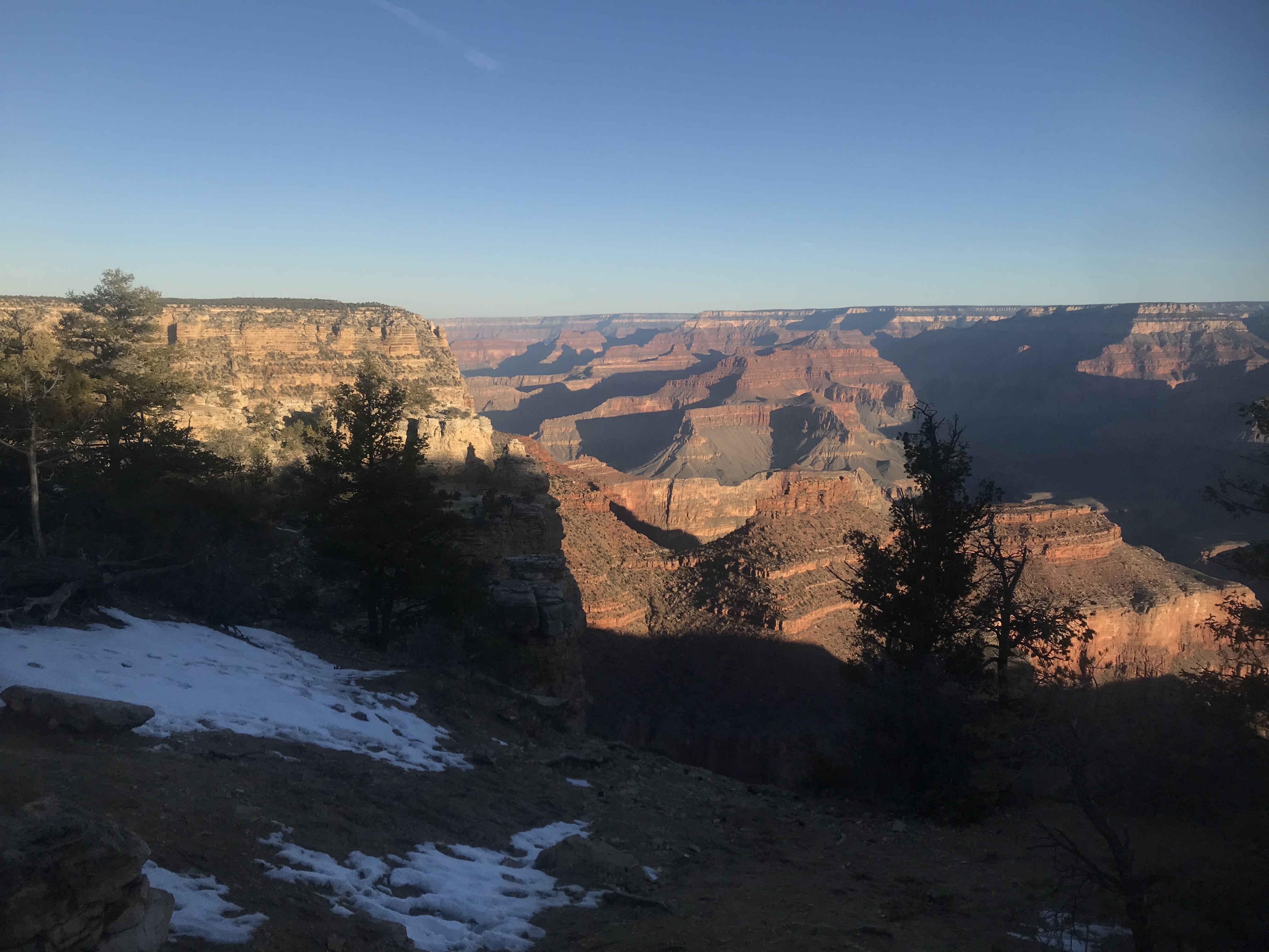
If you can make it to the Rim for sunrise, do it. Yes, this is super early in summer. It’s still worth it. From there, head over to the red line, which backs up substantially in the afternoon. Take it out to Hermits Rest and back, stopping at each overlook to admire the changing views of Grand Canyon as the light and angles change.
Powell, Hopi, and Mojave Points, as well as Hermits Rest are all essential stops on this route. The Rim Trail extends 14 miles east from hermits rest and makes a great path to walk along the rim of Grand Canyon. The stretches that parallel the Red shuttle tend to be much quieter than the busier sections in the village itself as well, it should be noted.
Once you have returned to Grand Canyon Village, you could grab something to eat at one of the hotels or proceed to walk or shuttle back to the visitor center at Mather Point. I’d recommend walking; it should be noted that this stretch of the Rim Trail is fully accessible.

Grand Canyon National Park

Grand Canyon National Park
Having returned to the visitor center, pick up your car and drive out to Desert View. More overlooks along the route provide spectacular views of the eastern canyon. After working your way out toward Desert View and exploring the area around the Watchtower, make your way back a few overlooks to Lipan Point. Here is your sunset stop for tonight.
As the sun drops into the canyon its rays fill the wide eastern canyon as the Colorado River makes its turn through Basalt Canyon and toward Granite Gorge. The light strikes the river as it begins to flow westwards, illuminating it as a golden ribbon within the canyon. Once the show is over, stick around until the stars have come out. The sight of the Milky Way rising over the canyon is unforgettable.

Grand Canyon National Park
Best Sunrise Spots
Mather Point
Yavapai Point
Powell Point
Yaki Point
Best Sunset Spots
Lipan Point
Desert View
Yavapai Point
Mohave Point
But in all honesty, don’t miss a sunrise or sunset because you are trying to make it to a particular spot. If you are somewhere on the rim within 30 minutes of sunset, find a close spot and enjoy the show, rather than risking missing it altogether!

Grand Canyon National Park
Grand Canyon (South Rim), Day 2
On your second day, after sunrise if you choose to partake again, make your way back to the visitor center and take the Orange line east to the South Kaibab Trail and depending on conditions, hike to either Ooh Aah Point Point (1.5 miles round trip) or Cedar Ridge (3 mi round trip). On returning to the rim, check out a ranger program before picking out another sunset spot, such as Yavapai Point. If you are a strong hiker and it is between October and April, you can consider extending your hike to Skeleton Point (6 miles round trip) but remember, down is optional and up is mandatory.

Grand Canyon National Park
Further Adventures at Grand Canyon
With more extensive trips you can consider backpacking in the canyon (permits required) or additional day hiking opportunities. The primary other hiking trail on the South Rim for first time visitors is the Bright Angel Trail, which can be taken to one of the first two resthouses (3 or 6 miles round trip, respectively) or Havasupai Gardens (9 miles round trip). A full day could extend to Plateau Point (11 miles round trip). Again, remember – down is optional, up is mandatory, and you will be coming up at the end of the hike when you are more fatigued. Allow 1/3 of your time for your descent and 2/3 for your return to the rim.

Grand Canyon National Park

Grand Canyon National Park

Grand Canyon National Park
Grand Canyon Geology
Grand Canyon National Park is a geologist’s dream. The rock exposed in Grand Canyon stretches back 1.8 billion years and includes primarily alternating periods of ocean coverage and desert. From youngest to oldest, the layers are as follows:
Kaibab Limestone
The youngest of the currently existent layers in Grand Canyon; a resistant, cliff-forming layer that is known for its rich marine fossil deposits due to its marine origins when the area lay under the eastern Pacific Ocean.
Toroweap Formation
A thin, sloping layer, signifying additionally prone to erosion. Composed of gypsum & shale with additional sandstone. The Toroweap was deposited by a combination of shallow sea environments and coastal dunes.
Coconino Sandstone
Thick cliffs formed by the largest desert represented in any Canyon layer. The Coconino is one of the most difficult layers to hike through due to the grade of the trails required to traverse its steep, thick cliffs. Evidence of wind-blown sand can be seen and felt in the layer today.
Hermit Shale
A sloping formation that frequently has poorly preserved plant fossils. Dark red due to the iron present in the rock.
Supai Group
A distinctive red layer rich in iron, as is the Hermit Shale. The Supai Group contains a mixture of slopes and cliffs. It’s perhaps most famous for its occurrence in Sedona, including Oak Creek Canyon. Formed in an environment similar to the Gulf Coast today.
Redwall Limestone
A thick layer of exceptionally pure, cliff forming limestone. Though it appears red, the natural color is whitish grey. The red color comes from minerals in layers above, carried down by melting snow & rain and staining the surface. As with the Coconino Sandstone, this is one of the most difficult layers to hike through due to its thickness.
Muav Limestone
A whitish layer of cliff-forming limestones beneath the Redwall. Several of the most spectacular Canyon waterfalls, including Roaring Springs and Thunder River, originate in the Muav.
Bright Angel Shale
A greenish-tinted sloping layer beneath the two limestones. The distinctive green color comes from trilobite excrement; so many trilobites were present in the swampy landscape at the time that they managed to stain the entire layer.
Tapeats Sandstone
A thick sandstone layer representing another desert landscape. While archeological sites can be found throughout the Canyon, the Tapeats cliffs can often be a particularly good spot to encounter them.
Vishnu Basement Rocks
Zoroaster Granite
Pink granitic igneous intrusions into the Vishnu Schist. An example of the influence of Clarence Dutton on the naming of Grand Canyon sites – he named many features in the canyon after Hindu and Egyptian deities.
Vishnu Schist
The oldest rock in the central Canyon, though not the oldest in the entire Canyon (that honor goes to the Elves Chasm gneiss). The Schist is an exceptionally erosion-resistant layer that currently represents the bottom of the canyon. Due to a combination of its resistance to erosion, a reduction in flow, and the impacts that Glen Canyon Dam has had on the Colorado River, the Canyon only deepens by about the thickness of a sheet of paper each year today.
The horizontally deposited layers were uplifted unusually regularly to form the Colorado Plateau, after which point, following the rise of the Rocky Mountains, the Colorado River began cutting through the rock to form the canyon. Using the strength of seasonal floods carrying boulders the size of cars and the continuous action of sediment suspended in the water wearing away at the riverbed and cutting down, the river cut into the plateau to form the main canyon, while the same process occurred on smaller scales on both rims, typically along fault lines, to form tributary canyons and the landscape we see today.
The North Rim, being higher, gets more snow and rain, and therefore has experienced more erosion and contributes more to the width of the canyon than the South Rim does. While the canyon’s depth is increasing only marginally today, the processes expanding it’s width are unaffected and continue to widen the canyon today.

Grand Canyon National Park
California Condors at Grand Canyon
Keep your eyes out for the largest birds in North America soaring above the canyon. With wingspans of nearly 10 feet, these are second only to the Andean condors in the Western Hemisphere. They were nearly extinct at one point due to lead contamination of the meat that they scavenge, before bouncing back with the help of a captive breeding program that involved trapping every known living condor.
Today every adult individual in the population is tagged with a radio collar and tracked using an instrument that looks remarkably like an old TV antenna. Each bird has a unique frequency so it is easily identifiable using the scanner. Additional birds are typically released into the population annually at the Vermilion Cliffs release site on the north side of the river. The birds mate for life and build nests on the canyon cliffs, typically producing one egg every other year. Juveniles reach adulthood at age 6, when they attain their classic pink head coloring.
Grand Canyon Flora and Fauna
Arizona is the third most biodiverse state in the United States, after California and Texas. Grand Canyon is no exception. Beyond the California Condor, its biodiversity is similar to hiking from Mexico to Canada. If one views the park within its broader region, which includes Humphrey’s Peak, Arizona’s highest, the regional biodiversity is similar to traveling from Mexico to Alberta. In 50 miles, one encounters 10,000 feet of elevation change and travels the equivalent of 1750 miles. Within the park itself are found at least 5 (depending somewhat on the source) distinct ecosystems or life zones, listed from the North Rim to the Colorado River, in decreasing elevation. C. Hart Merriam was the first European American to identify these.
Mixed Conifer Forest
Found only on the North Rim, the highest and coolest community in the park. It includes several subcommunities depending on the elevation. Summers are cool (average temperature 75 F/24 C high, 44 F/7 C low) and winters extreme in their conditions (average temperature 39 F/4 C high, 17 F/-8 C low) with 11 feet (3.5 m) of snow. Precipitation overall averages 25 inches (64 cm). Originally labeled the “Canadian life zone” by Merriam.
Ponderosa Pine Forest
Present on both the North and South Rims, between just shy of 7000 ft (2130 m) to over 8000 ft (2440 m). They form a transition zone between the mixed conifer/Canadian zone and the pinyon juniper woodland/upper Sonoran zone. Air temperatures are slightly cooler than in the pinyon juniper forest; precipitation slightly greater. Merriam referred to this as the “transition zone.”
Pinyon-Juniper Woodland
Very common on the Coconino Plateau, within the canyon and along the warm, sunny portions of the canyon rim that are impacted by upwelling warm air from inside the canyon. Merriam called this the “upper Sonoran zone.” Trees are shorter here. Ponderosas cannot grow due to lower precipitation levels.
Summer temperatures average 82 F/28 C high, 50 F/10 C low) and winters are cold though not as extreme as the conditions in the conifer forests (average temperature 44 F/7 C high, 20 F/-7 C low) with 11 feet (3.5 m) of snow. Precipitation overall averages 15 inches (38 cm). Pinyon-juniper woodland can be generally found from a bit over 5000 ft (1525 m) to just shy of 7000 ft (2130 m) in elevation.
Desert Scrub
Merril’s “lower Sonoran life zone.” These are the iconic Arizona desert communities – thing prickly pear, barrel cactus, etc. It’s the hottest and driest of the canyon communities and life is adapted to that fact. Summer temperatures are extreme, averaging 103 F/39 C high, 74 F/23 C low) with temperatures reaching 120 degrees not uncommon.
Winters are comparatively mild, with average temperatures reaching 58 F/14 C high, 32 F/0 C low. (That said, being a desert, it is possible of getting much hotter and colder, with temperatures reaching 120 in the summer and winter lows in the 20s not unheard of. Precipitation overall averages 9 inches (23 cm) per year, including 2 inches (5 cm) of snow. It has the broadest elevation range of any canyon life zone, from around 3000 ft (915 m) to over 5000 ft (1525 m).
Riparian
Found along the Colorado, its tributaries (such as the Little Colorado River and Bright Angel Creek), and canyon springs. Extreme diversity thrives where water exists in the desert. Air temperatures and precipitation, however, can be similar to the desert scrub zone. This zone reaches from around 2000 ft (600 m, the bottom of the canyon) to just shy of 3000 ft (915 m).
What About Grand Canyon’s North Rim?
It’s a four hour drive from the South Rim to the North Rim under normal conditions. I cover the North Rim here. Keep in mind that the North Rim is only open from May 15-November 30th annually and typically closes either the evening of the 30th or at 8 AM on December 1st.

Grand Canyon National Park

Grand Canyon National Park

Grand Canyon National Park
หนังโป๊
Having read this I believed it was rather enlightening. I appreciate you taking the time and energy to put this information together. I once again find myself spending a lot of time both reading and leaving comments. But so what, it was still worthwhile.
Haircuts
very nice publish, i certainly love this web site, carry on it