AZT Passage 16: Gila River Canyons
Arizona Trail Day 65
Trans-Arizona/Utah Day 73
Welcome back to Aspen’s Tracks, thruhiking the Arizona Trail southbound from Utah to Mexico. Today’s route covers backpacking the stretch of Passage 16, the Gila River Canyons, between my first night’s camp on the passage at the Gila River, along the river headed east toward the Kelvin-Riverside Bridge. You can find today’s hiking logistics below the photo documentation and trail journal of the route.
If you missed my last entry covering the leg through the prior segment of the Gila River Canyons, that can be found here. The next entry will cover the continued journey along the Gila toward the crossing at the Kelvin-Riverside Bridge. If you enjoy these accounts, please do subscribe to follow along to make sure that you don’t miss out on here or any future accounts to come!
(Note: the photos herein are smaller and at 50% quality, however, full quality ones are available to those interested, please contact me separately if so. This change was made to speed page loading but if you would prefer the full quality images please leave a comment to let me know).
In the land of Arizona
“The Arizona Trail,” Dale R Shewalter
Through desert heat or snow
Winds a trail for folks to follow
From Utah to Old Mexico
It’s the Arizona Trail
A pathway through the great Southwest
A diverse track through wood and stone
Your spirit it will test
Some will push and pedal
And some will hike or run
Others will ride their horse or mule
What else could be more fun?
Oh, sure you’ll sweat and blister
You’ll feel the miles each day
You’ll shiver at the loneliness
Your feet and seat will pay
But you’ll see moonlight on the borderlands
You’ll see stars on the Mogollon
You’ll feel the warmth of winter sun
And be thrilled straight through to bone
The aches and pains will fade away
You’ll feel renewed and whole
You’ll never be the same again
With Arizona in your soul
Along the Arizona Trail
A reverence and peace you’ll know
Through deserts, canyons, and mountains
From Utah to Old Mexico
Arizona Trail: Gila Camp & Javelinas
Well, today started and ended really cool. This morning I stumbled on a whole group of javelinas right along the trail. It ended with a fantastic sunset as well. In between, I had some major issues trying to filter the Gila River – I’m convinced a settling bucket would have been necessary given the sediment and flow. resulting in what I planned to be a scenic potential side trip up Walnut Canyon becoming an important mandatory one for water. I did manage to recoup some time near the end of the day and get to a spot to enjoy the sunset as well as put myself in position for a great sunrise the next morning.
As I’m getting on the trail this morning, I’m hiking along the river, absorbed in some of the most beautiful morning light that I’ve seen in a while. A pack of javelina suddenly burst out of the vegetation on my left, and run along the trail ahead of me, then dart back into the vegetation on the right. I can’t pull my phone out fast enough for a photo or video, but it was a thrilling moment in the Arizona countryside.

Arizona Trail, Passage 16 (Gila River Canyons)

Arizona Trail, Passage 16 (Gila River Canyons)

Arizona Trail, Passage 16 (Gila River Canyons)
Arizona Trail: Javelinas-Gila River Access
Following my javelina encounter, I continued eastward along the trail, tracing the course of the Gila River. The trail passes some old mining equipment abandoned along its route, and the landscape continues to be some of the most remote yet encountered along the trail. Rugged mountains, saguaros and other Sonoran plants are the only consistent life to be seen. Aside from the abandoned mining equipment and the trail itself, there’s essentially no evidence of human life out here.

Arizona Trail, Passage 16 (Gila River Canyons)

Arizona Trail, Passage 16 (Gila River Canyons)
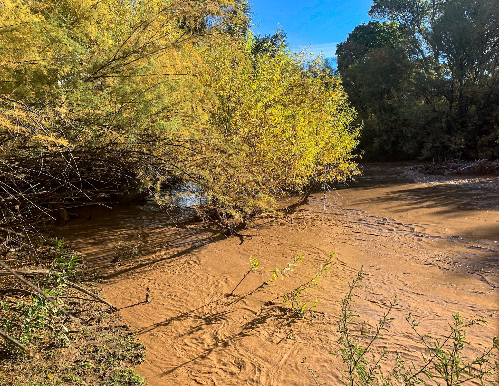
There’s also virtually no consistent visible water supply – partially due to the fact that the Gila River is so choked in trees, unless you are sufficiently high above it, or right beside it, its impossible to actually see the water there even when it is present (as it is in this case). I make one brief attempt to reach the river to refill on water, ducking through mesquite and cottonwood branches, ultimately only to reach a river that is essentially rushing chocolate milk, moving too quickly and sedimented to be worth even attempting to collect water from.

Arizona Trail, Passage 16 (Gila River Canyons)

Arizona Trail, Passage 16 (Gila River Canyons)

Arizona Trail, Passage 16 (Gila River Canyons)

Arizona Trail, Passage 16 (Gila River Canyons)

Arizona Trail, Passage 16 (Gila River Canyons)

Arizona Trail, Passage 16 (Gila River Canyons)
Arizona Trail: Gila Access-Walnut Canyon
decide to hold off until I reach Walnut Canyon farther upstream. I should have enough water left in my stash to reach that point. The trail passes through some scenic rocky washes and floodplain forests of mesquite, and also affords some scenic views along the Gila River while crossing between different drainages.

Arizona Trail, Passage 16 (Gila River Canyons)


Arizona Trail, Passage 16 (Gila River Canyons)


Arizona Trail, Passage 16 (Gila River Canyons)
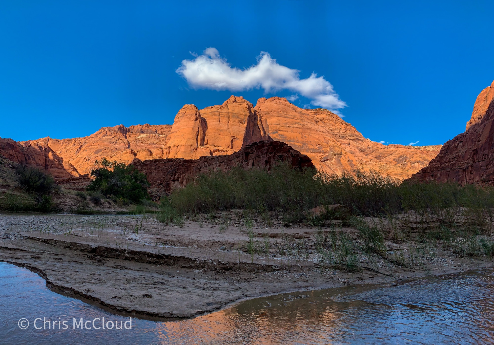
Walnut Canyon
Several hours into the hike, I descend into the lower wash of Walnut Canyon, the spot I planned in advance for a water resupply. This point offers easy access down to the river under current conditions, and alternatively, should that fail, there’s apparently an artesian well upstream in the canyon itself that I can take advantage of should that become necessary.

Arizona Trail, Passage 16 (Gila River Canyons)
Unfortunately, it quickly becomes evident that there will be no successful filtering of the Gila River as it is currently flowing. Without a settling bucket, it’ll take forever to filter the Gila and I’ll probably ruin a filter in the process.
Walnut Canyon
So I head upstream to try and find water in the canyon itself, something that I’d hoped to do as a scenic side trip regardless but which has now become a necessity. According to my notes from the AZT guidebook, it shouldn’t be more than a couple miles round trip. As it turns out, its even less, but the scenery is so spectacular in the canyon that I can’t help but proceed slightly farther and take it in.

Arizona Trail, Passage 16 (Gila River Canyons)

Arizona Trail, Passage 16 (Gila River Canyons)

Arizona Trail, Passage 16 (Gila River Canyons)

Arizona Trail, Passage 16 (Gila River Canyons)

Arizona Trail, Passage 16 (Gila River Canyons)

Arizona Trail, Passage 16 (Gila River Canyons)

Arizona Trail, Passage 16 (Gila River Canyons)


Arizona Trail, Passage 16 (Gila River Canyons)

Arizona Trail, Passage 16 (Gila River Canyons)


Arizona Trail, Passage 16 (Gila River Canyons)

Arizona Trail, Passage 16 (Gila River Canyons)


Arizona Trail, Passage 16 (Gila River Canyons)

Arizona Trail, Passage 16 (Gila River Canyons)

Arizona Trail, Passage 16 (Gila River Canyons)
Walnut Canyon-“The Spine” Gap
After returning to the crossing of the Walnut Canyon wash by the Arizona Trail, I continue east. At the start of the day, I had 14 miles to go to the Kelvin/Riverside trailhead, and was initially hoping to make it there early enough today to possibly get a pizza delivered there, which I heard might be a possibility. Looking less likely now, but I’m not the type to give up easily.
The trails continues to curve through forests of mesquite and beneath buttes and cliffs that gain color from the sun as the day goes on. More small streams flow out of the drainages separating these features, so that there is more water in this dry landscape than I had been expecting. Not something that I will complain about by any means, of course. As the day wears on, the mesquite leaves begin to fold in response to the dwindling light, though for my purposes there is still quite a bit.


Arizona Trail, Passage 16 (Gila River Canyons)

Arizona Trail, Passage 16 (Gila River Canyons)

Arizona Trail, Passage 16 (Gila River Canyons)

Arizona Trail, Passage 16 (Gila River Canyons)

Arizona Trail, Passage 16 (Gila River Canyons)

Arizona Trail, Passage 16 (Gila River Canyons)

Arizona Trail, Passage 16 (Gila River Canyons)
Arizona Trail: Gila River Sunset
The river valley narrows as the trail winds east, and as the day comes to a close, it passes through a narrow gap between a spine ridgeline (possibly literally named “The Spine,” looking at the topo map) on the north side of the river, and a mountain rising steeply from the river on the south side.

Arizona Trail, Passage 16 (Gila River Canyons)

As I reach this point, color is lighting up the sky from the sunset, and the clouds curve like sails across the sky. After making camp for the evening, I experiment some with some saguaro light painting using my headlamp against the sunset light that remains, then turn in for the night. About 7 more miles to go to the Kelvin/Riverside Bridge and the end of the passage, and on the way tomorrow I’ll pass by the Golden Spike, the last completed mile of trail, finished in 2011.

Arizona Trail, Passage 16 (Gila River Canyons)

Arizona Trail, Passage 16 (Gila River Canyons)


Arizona Trail, Passage 16 (Gila River Canyons)

Arizona Trail, Passage 16 (Gila River Canyons)

Arizona Trail, Passage 16 (Gila River Canyons)

Arizona Trail, Passage 16 (Gila River Canyons)

Arizona Trail, Passage 16 (Gila River Canyons)

Arizona Trail, Passage 16 (Gila River Canyons)

Arizona Trail, Passage 16 (Gila River Canyons)

Arizona Trail, Passage 16 (Gila River Canyons)

Arizona Trail, Passage 16 (Gila River Canyons)

Arizona Trail, Passage 16 (Gila River Canyons)

Arizona Trail, Passage 16 (Gila River Canyons)

Arizona Trail, Passage 16 (Gila River Canyons)

Arizona Trail, Passage 16 (Gila River Canyons)

Arizona Trail, Passage 16 (Gila River Canyons)
Passage 16 Logistics
| Passage 16 (Gila River Canyons) | |
| AZTA Page and Map | Passage 16 (Gila River Canyons) Passage 16 Map Passage 16 Elevation Profile |
| Weather | Passage 16 Weather |
| Trail Surface | Dirt Singletrack |
| Length (Mi) | 25.7 |
| Season | September-May |
| Potential Water Sources | Gila River is unreliable and must be prefiltered and/or settled when flowing. Walnut Canyon may have water. Full sources & Current Status: Arizona Trail Water Sources |
| Trailheads | North: Tonto National Forest boundary South: Kelvin-Riverside Bridge |
| Trailhead Access | North: No vehicular access South: Vehicular access via paved road |
| Wilderness | No |
| Possible resupply points | Superior (north end) Kearny (south end, requires roadwalk or hitch) |
| ATA-Rated Difficulty | Difficult |
| Potential campsites | Terrain is pretty dry and rugged, but there are numerous campsites along the section paralleling the Gila River. |
| Ecosystems Traversed | Arizona Upland, mostly Riparian along the Gila River |
| Highlights | Rugged canyon scenery Gila River Walnut Canyon Wildlife |
| Dog friendly? | Yes |
| Bike friendly? | Yes |
| Hazards | One of driest passage on trail. Gila River is unreliable and must be prefiltered and/or settled when flowing. Walnut Canyon may have water. Extreme Heat in summer Flash flooding during monsoon (July-September) |
Passage 16 Ecology
| Arizona Upland | Riparian | |
| Common Trees/Shrubs | * Fairy duster * Blue and littleleaf palo verde * Fremont wolfberry * Graythorn * Ocotillo * Red barberry * Scrub-live oak * Snapdragon-penstemon * Turpentine bush * Velvet mesquite * Whitethron acacia | * Fremont Cottonwood * Tamarisk/salt cedar (invasive) * Goodding’s willow |
| Common herbaceous plants | * California flannelbush [rare in Arizona, Superstition Mountains included] * Bluedicks * Brittlebush * California poppies * Creamcups * Desert chicory * Desert rockpea * Desert windflower * Fringed red maids * Globemallows * Lupines * Sego-lily | |
| Common succulents | * Arizona pencil cholla * Banana yucca * Soaptree yucca * Buckhorn cholla * Cane cholla * Chainfruit * Hedgehog cactus * Pencil cholla * Pincushion cactus * Prickly pears * Saguaro * Teddybear cholla |
Jenna Lundby
A round of applause for this blog—it consistently promotes positivity.
Haircuts
Thank you for being of assistance to me. I really loved this article.