Sand Hill Trail
After deliberations this morning, I finally haul myself up to the Mill Creek Trailhead on state land within the Red Cliffs Desert Reserve just outside St George, Utah. It quickly becomes evident, though, that my initial goal for the day, hiking Washington Hollow at the adjacent Red Cliffs National Conservation Area, is not feasible. Having already completed most of the other trails accessible in the area of that trailhead, I decide to settle for a loop up Sand Hill Trail and returning on Dino Cliffs Trail, connecting the two with a jaunt on Grapevine Trail. Should make for a great sunset loop.
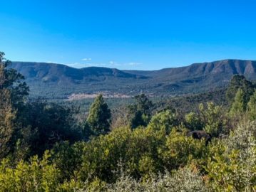
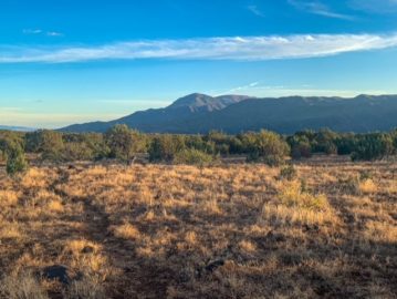
I hike up Mill Creek and turn onto Bone Wash for a short distance, then branch again onto Sand Hill as Bone Wash continues ahead to descend into the wash. Hiking up Sand Hill, the trail climbs steadily across a mountain of sand between Bone Wash on the left and another wash on the right, offering unobstructed views of the heart of the Red Cliffs area (toward Washington Hollow and, further east, Cottonwood Canyon), the Pine Valley Mountains, St George Basin, Beaver Dam Mountains, Virgin Mountains, Zion National Park, and more.

Sand Hill Trail
Red Cliffs Desert Reserve, Utah

Sand Hill Trail
Red Cliffs Desert Reserve, Utah


Sand Hill Trail
Red Cliffs Desert Reserve, Utah

Sand Hill Trail
Red Cliffs Desert Reserve, Utah

Sand Hill Trail
Red Cliffs Desert Reserve, Utah

Sand Hill Trail
Red Cliffs Desert Reserve, Utah
Grapevine Trail
Descending the east side of Sand Hill, the clouds look amazing over the cliffs and mountains, and the light angles are constantly changing as the rock glows in the late afternoon light. I hit Grapevine and turn right, hiking down toward the Dino Cliffs junction. The views of Zion and Sand Mountain on this stretch are nice…but otherwise this is relatively forgettable, a connector.
Dino Cliffs Trail
After a mile or so, I hang a right on the Dino Cliffs trail as the rock glows red all around. The sunset view with the cliffs silhouetted is amazing. The incredible clouds from earlier catch fire and glow across the sky.
I discover too, that there is an upper and lower trail on the west side of Dino Cliffs. This time, I wound up hiking on the upper trail, which has some substantial exposure in one or two spots; I probably wouldn’t recommend it for anyone with a fear of heights; they should probably use the lower trail instead. Finding the exit gate was a bit of an adventure as the sunset had passed and it was relatively dark by then…but after that it’s a pretty straightforward road walk back to the Mill Creek trailhead where I initially parked.
In retrospect, I might have done the loop in reverse, as that would have allowed the wider views at sunset itself. But it was pretty beautiful either way.

Sand Hill Trail
Red Cliffs Desert Reserve, Utah

Sand Hill Trail
Red Cliffs Desert Reserve, Utah

Sand Hill Trail
Red Cliffs Desert Reserve, Utah

Sand Hill Trail
Red Cliffs Desert Reserve, Utah


Sand Hill Trail
Red Cliffs Desert Reserve, Utah
Red Cliffs Desert Reserve Route Overview
Getting There
There are two options for the starting point: Dino Cliffs Trailhead or Mill Creek Trailhead. I’ll describe it as I hiked it. The two are easily joined by a dirt road walk of a couple miles. Traffic levels are very low on the two roads used to link them. Take trekking poles; they will be a great help on Sand Hill. Trail maps can be found at the Public Lands Information Center in St George.
To access the trailhead, cross I-15 on Washington Parkway and turn right at the large water truck at the current construction site that has begun somewhere near the trailhead access. Drive up to the water tower and follow the road as it turns left. Proceed down the hill and take the substantial right onto the road leading to the Mill Creek Trailhead.
Mill Creek Trailhead to Sand Hill Trail
From Mill Creek trailhead, hike north on Mill Creek toward the Pine Valley Mountains. At the first junction, turn right onto Bone Wash. Enjoy the views across the Red Cliffs and down into the textured rock bordering the north side of the wash, but watch for footprints in the sand breaking away at an angle to the right. The Bone Wash/Sand Hill junction is relatively discreet; once you turn off, follow the sand footprints religiously and watch for occasional brown, carsonite posts that serve as the markers hiking up Sand Hill.

Red Cliffs Desert Reserve, Utah

Red Cliffs Desert Reserve, Utah


Sand Hill Trail
Red Cliffs Desert Reserve, Utah

Sand Hill Trail
Red Cliffs Desert Reserve, Utah

Sand Hill Trail
Red Cliffs Desert Reserve, Utah

Sand Hill Trail
Red Cliffs Desert Reserve, Utah
Sand Hill Trail
The trail eventually widens somewhat and climbs an arm of Sand Hill between the impressive Bone Wash on the north side and a smaller wash on the south side (which still has some impressive hoodoo-like formations in its upper sections) and ascends to the summit. There are some very impressive views on both sides of the summit across the Elephant Arch and Bone Wash areas to Washington Hollow and the Pine Valley Mountains beyond. To the east, you can see the Virgin River Rim; Zion National Park; Smithsonian Butte/Gooseberry Mesa area; Canaan Mountain; and the Hurricane Cliffs.
The trail descends to the junction with the Grapevine Trail after X miles from the split with Bone Wash.
Grapevine Trail & Dino Cliffs Trail
Turn right on Grapevine and proceed south for X miles to the junction with Dino Cliffs. Turn right and head west. There’s an unclear spot where the path splits about a quarter mile tops in. The official route cuts to the left over to an extended rock ledge. The two paths merge again shortly after. Follow the path along the namesake cliffs. Around the halfway point of the route, the path splits.
If you continue hiking straight on the upper option, you get incredible views, but avoid most dinosaur tracks and have to tolerate slight exposure in places. It will be fine for most people and the trail is obviously official; however, those with any fear of heights or those who want to see most of the obvious dinosaur tracks should take the lower option that descends into the washes at the base of the cliffs. Proceed to the western trailhead along either route.

Dino Cliffs Trail
Red Cliffs Desert Reserve, Utah


Dino Cliffs Trail
Red Cliffs Desert Reserve, Utah


Dino Cliffs Trail
Red Cliffs Desert Reserve, Utah

Dino Cliffs Trail
Red Cliffs Desert Reserve, Utah


Dino Cliffs Trail
Red Cliffs Desert Reserve, Utah

Dino Cliffs Trail
Red Cliffs Desert Reserve, Utah


Dino Cliffs Trail
Red Cliffs Desert Reserve, Utah

Dino Cliffs Trail
Red Cliffs Desert Reserve, Utah

Dino Cliffs Trail
Red Cliffs Desert Reserve, Utah

Dino Cliffs Trail
Red Cliffs Desert Reserve, Utah

Dino Cliffs Trail
Red Cliffs Desert Reserve, Utah

Dino Cliffs Trail
Red Cliffs Desert Reserve, Utah

Dino Cliffs Trail
Red Cliffs Desert Reserve, Utah

Dino Cliffs Trail
Red Cliffs Desert Reserve, Utah

Dino Cliffs Trail
Red Cliffs Desert Reserve, Utah

Dino Cliffs Trail
Red Cliffs Desert Reserve, Utah

Dino Cliffs Trail
Red Cliffs Desert Reserve, Utah


Dino Cliffs Trail
Red Cliffs Desert Reserve, Utah

Dino Cliffs Trail
Red Cliffs Desert Reserve, Utah

Dino Cliffs Trail
Red Cliffs Desert Reserve, Utah

Dino Cliffs Trail
Red Cliffs Desert Reserve, Utah
Red Cliffs Desert Reserve: Sand Hill-Dino Cliffs Route Logistics
| Red Cliffs NCA: Sand Hill-Dino Cliffs Loop | |
| Land Manager | Utah State Land within National Conservation Area/Red Cliffs Desert Reserve boundary |
| Trails Involved | Mill Creek (part) Bone Wash (part) Sand Hill Grapevine (part) Dino Cliffs |
| Trail Surface | Singletrack (Bone Wash, Sand Hill & Dino Cliffs) Two track (Mill Creek, Grapevine) |
| Length | Minor additional spurs to Deep Pond (0.1 mile one way), Green Falls (0.3 miles), Wassataquoik Lake Overlook (0.3 mile) |
| Ideal Season | Fall, winter, spring |
| Water Sources | None |
| Trailhead | Mill Creek Trailhead; could also begin at Dino Cliffs Trailhead |
| Trailhead Access | Currently, AWD SUV required to access either trailhead due to construction impacts in the last week closing the better road to the Mill Creek Trailhead. You have to go over a hill by way of Dino Cliffs now, and the road condition of that route is noticeably worse. Not recommended for anything less than an AWD SUV now. |
| Wilderness | No, though there are great views into the Cottonwood Canyon Wilderness |
| Campsites | No camping outside of designated campsites or wilderness within the NCA/Desert Reserve boundary |
| Hazards | Heat (in summer) Dehydration |
| Highlights | On route described above: * Views of Zion National Park * Views of Pine Valley Mountains * Views of Cottonwood Canyon Wilderness, notably Washington Hollow area * Views of Broken Mesa lava flow * Views of Virgin Mountains and Beaver Dam Mountains * Views of St George * Dinosaur tracks * Lots of red rock, especially up close on Dino Cliffs segment |