AZT Passage 16: Gila River Canyons
Arizona Trail Day 66
Trans-Arizona/Utah Day 74
Welcome back to Aspen’s Tracks, thruhiking the Arizona Trail southbound from Utah to Mexico. Today’s route covers backpacking the stretch of Passage 16, the Gila River Canyons, on the eastern stretch of its segment paralleling the Gila River. You can find today’s hiking logistics below the photo documentation and trail journal of the route.
If you missed my last entry covering the leg through the western segment of the Gila River Canyons, that can be found here. The next entry will cover my resupply stop in Kearny. If you enjoy these accounts, please do subscribe to follow along to make sure that you don’t miss out on here or any future accounts to come!
(Note: the photos herein are smaller and at 50% quality, however, full quality ones are available to those interested, please contact me separately if so. This change was made to speed page loading but if you would prefer the full quality images please leave a comment to let me know).
In the land of Arizona
“The Arizona Trail,” Dale R Shewalter
Through desert heat or snow
Winds a trail for folks to follow
From Utah to Old Mexico
It’s the Arizona Trail
A pathway through the great Southwest
A diverse track through wood and stone
Your spirit it will test
Some will push and pedal
And some will hike or run
Others will ride their horse or mule
What else could be more fun?
Oh, sure you’ll sweat and blister
You’ll feel the miles each day
You’ll shiver at the loneliness
Your feet and seat will pay
But you’ll see moonlight on the borderlands
You’ll see stars on the Mogollon
You’ll feel the warmth of winter sun
And be thrilled straight through to bone
The aches and pains will fade away
You’ll feel renewed and whole
You’ll never be the same again
With Arizona in your soul
Along the Arizona Trail
A reverence and peace you’ll know
Through deserts, canyons, and mountains
From Utah to Old Mexico
Arizona Trail: Sunrise in the Gila River Canyons
Sunrise breaks in the morning, another spectacular one. The one to two week cycle of clouds and potential weather appears to be continuing. As I get on the trail and begin to head into the river canyon, some of the saguaros appear silhouetted against the clouds above the rising sun.

Arizona Trail, Passage 16: Gila River Canyons

Arizona Trail, Passage 16: Gila River Canyons

Arizona Trail, Passage 16: Gila River Canyons


Arizona Trail, Passage 16: Gila River Canyons


Arizona Trail, Passage 16: Gila River Canyons

Arizona Trail, Passage 16: Gila River Canyons

Arizona Trail, Passage 16: Gila River Canyons
AZT: Gila River Camp 2-Western Gila Canyon
The trail climbs and begins to roll along beside the river again. Morning light illuminates the east face of the mountain ridge just north of the river and trail. Looking back to the west, I can see the light illuminating more isolated peaks where I’ve just come from, back toward Cochran and the climb to Martinez Canyon, on the other end of the flatter and more open stretch of the passage.
A train passes along the tracks across the river as the trail rolls through the couple river mile long canyon. It provides a nice sense of scale and complement to the tan rocks and tree foliage. As the river begins to curve out of the canyon, the trail continues along a series of bluffs above the river, providing some of the best views along the length of the river portion of the passage.

Arizona Trail, Passage 16: Gila River Canyons

Arizona Trail, Passage 16: Gila River Canyons


Arizona Trail, Passage 16: Gila River Canyons


Arizona Trail, Passage 16: Gila River Canyons

Arizona Trail, Passage 16: Gila River Canyons

Arizona Trail, Passage 16: Gila River Canyons

Arizona Trail, Passage 16: Gila River Canyons
Arizona Trail: Western Gila River Canyon
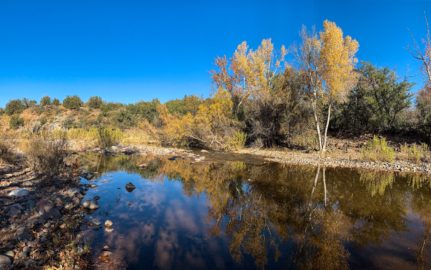
The greenery along this stretch is really striking as the trail exits the river canyon. The river makes several bends here, and this, along with the trail’s elevation above it, makes for some nice views of not just the trees framing the riparian corridor, but the river itself within the trees as well, framed within the golden cottonwood foliage.
At few points has the significant impact of such a quantity of water on its surrounding landscape been quite as evident. It’s almost like the trees fall right into the saguaros that surround in the landscape (or vice versa). And yet, at the same time, it also seems like the entire river valley is just stuffed with trees. The contrast between the number of trees along the river and the utter lack of them around it, is incredibly, if unsurprisingly, striking.


Arizona Trail, Passage 16: Gila River Canyons

Arizona Trail, Passage 16: Gila River Canyons

Arizona Trail, Passage 16: Gila River Canyons

Arizona Trail, Passage 16: Gila River Canyons

Arizona Trail, Passage 16: Gila River Canyons
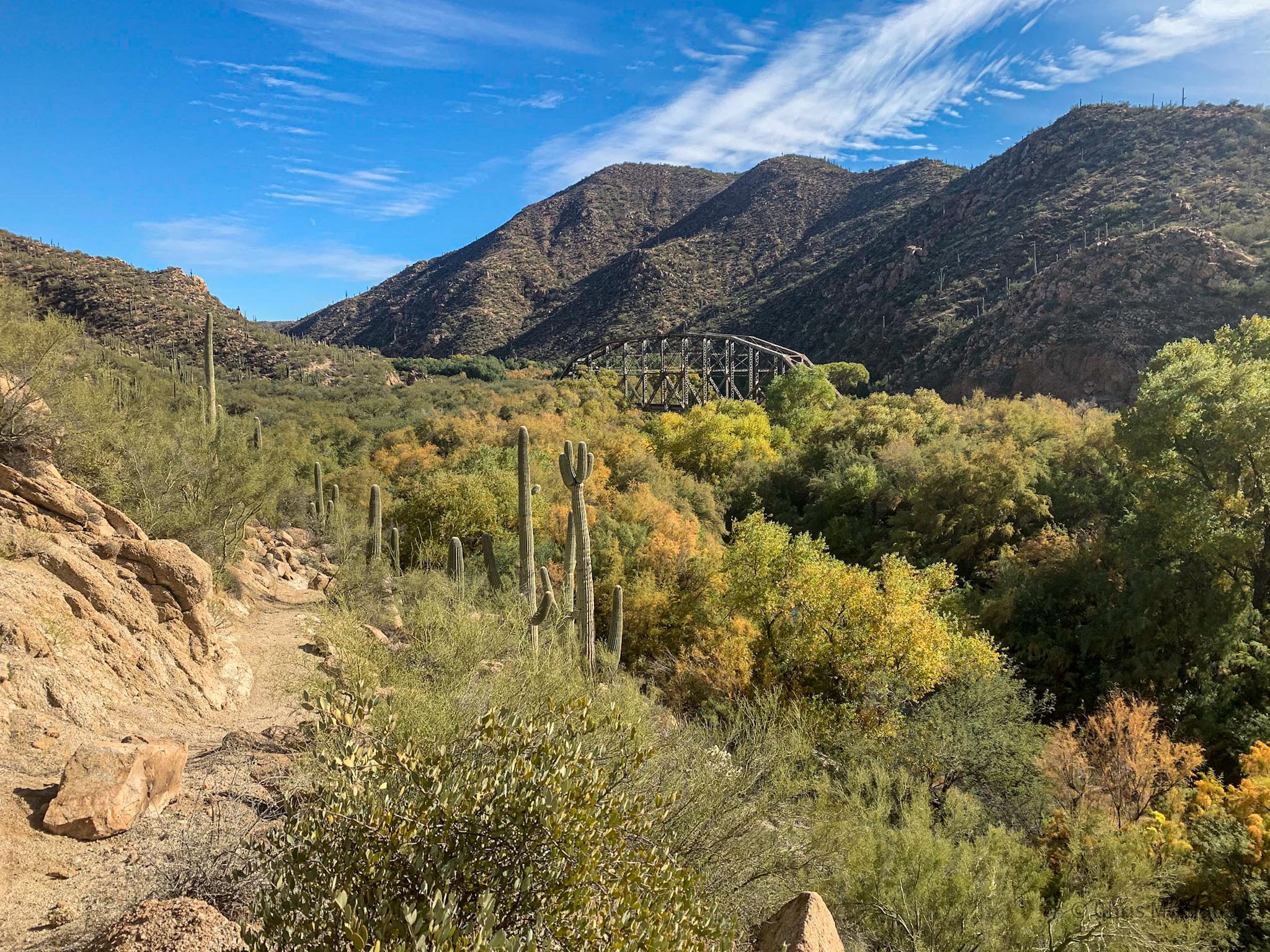
Western Gila River Canyon (East Portal)-Golden Spike
Some of the ocotillo are blooming from the recent rains as well, which is always nice to see. The terrain starts to flatten out somewhat, yet the trail still remains above the river so the views of it are still striking. A few helicopters fly by, another somewhat unwelcome intrusion to the peace of the scene, although not as jarring as the jet flyover back in the Mazatzals. As the river enters a second canyon, the train tracks soon cross to my side of the river, making for a very picturesque scene where the picturesque rail bridge crosses among the cottonwood foliage. One final climb and the trail arrives at the Golden Spike.

Arizona Trail, Passage 16: Gila River Canyons

Arizona Trail, Passage 16: Gila River Canyons

Arizona Trail, Passage 16: Gila River Canyons

Arizona Trail, Passage 16: Gila River Canyons

Arizona Trail, Passage 16: Gila River Canyons

Arizona Trail, Passage 16: Gila River Canyons
Golden Spike of the Arizona Trail
In 2011, this remote area was the last mile of the Arizona Trail to be completed. To commemorate the occasion, the Bureau of Land Management and the AZTA installed a USGS-style marker with the inscription “US Department of the Interior – Bureau of Land Management Cadastral Survey” and on the inside “Arizona National Scenic Trail – Completed December 16, 2011.”
On the concrete cylinder encasing the marker were added the initials “D.S.” for Dale Shewalter, the man who came up with the idea for the trail and became known as the “Father of the Arizona Trail.” Looking around, it’s pretty easy to tell why this was the last mile, as it is one of the most remote, so getting the people out here and constructing this passage must have been no easy feat.


Arizona Trail, Passage 16 (Gila River Canyons)
AZT: Golden Spike-Kelvin/Riverside Bridge
The view from the Golden Spike is quite picturesque, and I take a moment to soak it in before continuing. A mining area comes into view to the west, my first indication that the day’s destination is approaching. The Kelvin/Riverside Bridge isn’t immediately apparent, but I know that the mine is on the other side of the road to Kearny, farther east than the bridge, so I must be approaching the bridge as well.
The trail descends down off the bluffs, and eventually winds up on a dirt road briefly, then crosses Mineral Creek. The foliage here is still beautiful, but some appears less welcome – some of the trees look like invasive tamarisk, an Eastern European species that has been taking over along waterways in the west. The cascade of the stream as it approaches the Gila River is nice, though.
I arrive at the bridge and the Pinal County maintenance yard, where some kind workers give me an electrolyte drink and let me fill up on water. I find a spot under the bridge to camp for the night, and plan to head over to Kearny in the morning to pick up my next resupply package.

Arizona Trail, Passage 16: Gila River Canyons

Arizona Trail, Passage 16: Gila River Canyons

Arizona Trail, Passage 16: Gila River Canyons

Arizona Trail, Passage 16: Gila River Canyons

Arizona Trail, Passage 16: Gila River Canyons
Passage 16 Logistics
| Passage 16 (Gila River Canyons) | |
| AZTA Page and Map | Passage 16 (Gila River Canyons) Passage 16 Map Passage 16 Elevation Profile |
| Weather | Passage 16 Weather |
| Trail Surface | Dirt Singletrack |
| Length (Mi) | 25.7 |
| Season | September-May |
| Potential Water Sources | Gila River is unreliable and must be prefiltered and/or settled when flowing. Walnut Canyon may have water. Full sources & Current Status: Arizona Trail Water Sources |
| Trailheads | North: Tonto National Forest boundary South: Kelvin-Riverside Bridge |
| Trailhead Access | North: No vehicular access South: Vehicular access via paved road |
| Wilderness | No |
| Possible resupply points | Superior (north end) Kearny (south end, requires roadwalk or hitch) |
| ATA-Rated Difficulty | Difficult |
| Potential campsites | Terrain is pretty dry and rugged, but there are numerous campsites along the section paralleling the Gila River. |
| Ecosystems Traversed | Arizona Upland, mostly Riparian along the Gila River |
| Highlights | Rugged canyon scenery Gila River Walnut Canyon Wildlife |
| Dog friendly? | Yes |
| Bike friendly? | Yes |
| Hazards | One of driest passage on trail. Gila River is unreliable and must be prefiltered and/or settled when flowing. Walnut Canyon may have water. Extreme Heat in summer Flash flooding during monsoon (July-September) |
Passage 16 Ecology
| Arizona Upland | Riparian | |
| Common Trees/Shrubs | * Fairy duster * Blue and littleleaf palo verde * Fremont wolfberry * Graythorn * Ocotillo * Red barberry * Scrub-live oak * Snapdragon-penstemon * Turpentine bush * Velvet mesquite * Whitethron acacia | * Fremont Cottonwood * Tamarisk/salt cedar (invasive) * Goodding’s willow |
| Common herbaceous plants | * California flannelbush [rare in Arizona, Superstition Mountains included] * Bluedicks * Brittlebush * California poppies * Creamcups * Desert chicory * Desert rockpea * Desert windflower * Fringed red maids * Globemallows * Lupines * Sego-lily | |
| Common succulents | * Arizona pencil cholla * Banana yucca * Soaptree yucca * Buckhorn cholla * Cane cholla * Chainfruit * Hedgehog cactus * Pencil cholla * Pincushion cactus * Prickly pears * Saguaro * Teddybear cholla |
Cameron McLarty
To the aspenstracks.com webmaster, Thanks for the detailed post!