Roaring Brook-Wassataquoik Stream Lean-Tos
Sandy Stream Pond Trail, Russell Pond Trail South Jct to Sandy Stream Pond Outlet
Our first full day at Baxter State Park in north-central Maine after arriving from Boston yesterday. By midmorning, we are underway for the backpacking portion, on the trail to Russell Pond. We cross Roaring Brook and split off toward Sandy Stream Pond on the right.
It doesn’t take long for the first problem to occur, I slip near a boardwalk close to the start of the Sandy Stream Pond Trail, and somehow one of the clips of my hip belt breaks off. Keeping it secured from here, with the entire trip ahead of us, is going to be a challenge, especially in such a manner to translate any weight from the pack to my legs effectively. A rather inauspicious start, one might say. It starts popping apart repeatedly pretty quickly, so some experimentation or ingenuity throughout the day may be required to reach a solution.

Baxter State Park, Maine

Baxter State Park, Maine
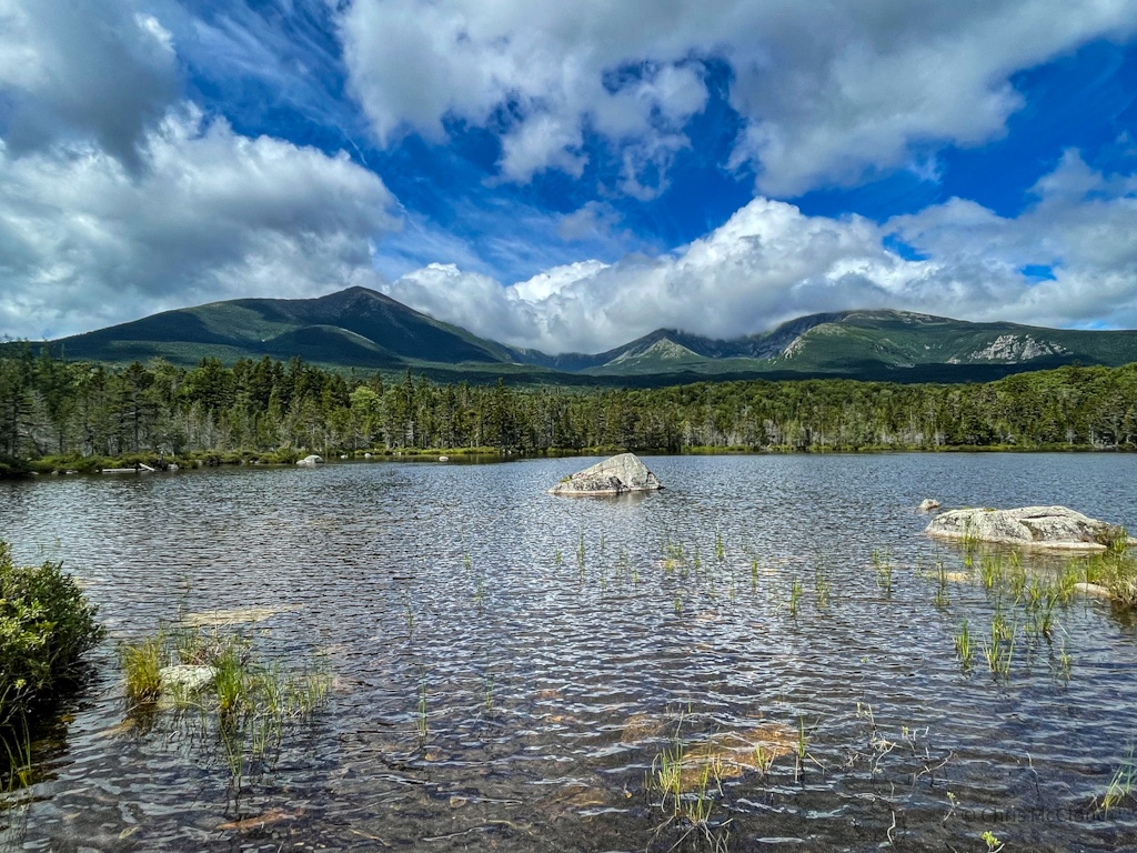
Still, we press on, and loop past Sandy Stream Pond, a frequent moose spotting site, and take a couple side loops to overlooks, but no moose. That’s not to say it isn’t gorgeous, though – the Katahdin massif rises above, though the iconic portions of Pamola, the Knife Edge, Baxter Peak, and the summit of Hamlin Peak are shrouded in the clouds.

Baxter State Park, Maine

Baxter State Park, Maine

Baxter State Park, Maine

Baxter State Park, Maine


Baxter State Park, Maine

Baxter State Park, Maine
Baxter State Park: Sandy Stream Pond Outlet-Russell Pond Trail North Jct
Rejoining the primary trail, we wrap past the outlet of the pond, where the view almost seems like a painting and an iridescent green dragonfly captures our collective attention. One final overlook follows, providing a view to Katahdin from the northeast shore of the pond, then a lengthy stretch follows made up mostly of mossy rocks. A bit of a technical surface for so early on.

Baxter State Park, Maine

Baxter State Park, Maine

Baxter State Park, Maine

Baxter State Park, Maine

Baxter State Park, Maine


Baxter State Park, Maine

Baxter State Park, Maine

Baxter State Park, Maine

Baxter State Park, Maine
Baxter State Park: Russell Pond Trail
Joining up with the Russell Pond Trail, we turn north toward the gap between the Howe Peaks arm of Katahdin and South Turner Mountain, though which Wassataquoik Stream flows, northward toward Russell Pond. The trail passes Whidden Ponds and begins losing elevation as it rolls through the gap and across a number of smaller streams flowing off of South Turner Mountain.

Baxter State Park, Maine


Baxter State Park, Maine
Baxter State Park: Wassataquoik Stream Trail (Russell Pond Jct to Wassataquoik Stream Lean Tos)
Stream condition reports from the ranger at Roaring Brook advise us to take Wassataquoik over the Roaring Brook Trail. Heading north, it’s a wet hike out to the Wassataquoik Stream lean tos, with a couple brief skirting views of the stream on the way, though its sound is generally present along with that of its tributaries flowing off South Turner Mountain.
Colorful fungi and wildflowers continue to dot the trail in places, and green moss and leaves are ever present. And the mud. Mud, mud, mud! Such is hiking in New England this summer, it would seem. We also spot a snake out sunning itself on the trail, before ultimately reaching a good access point for Wassataquoik Stream itself.

Baxter State Park, Maine

Baxter State Park, Maine


Baxter State Park, Maine

Baxter State Park, Maine

Baxter State Park, Maine


Baxter State Park, Maine
Wassataquoik Stream Access-Wassataquoik Stream Lean Tos
About halfway out the Wassataquoik Stream Trail, the trail approaches the stream itself close enough to offer direct access. As the trail makes its way north, it passes a number of views of mountains rising above the stream, then a beautiful patch of wildflowers. As the trail rounds the north flank of South Turner Mountain, it ultimately reaches the lean to campsite where I pause briefly to take in the view of the confluence of the two stream branches and scout the crossings I’m about to do.

Baxter State Park, Maine

Baxter State Park, Maine

Baxter State Park

Baxter State Park

Baxter State Park

Baxter State Park

Baxter State Park

Baxter State Park
Wet summer so far, lots of fungi visible along the trail no doubt enjoying the damp conditions

BAxter State Park, Maine

Baxter State Park, Maine

Baxter State Park, Maine

Baxter State Park, Maine

Baxter State Park, Maine

Baxter State Park, Maine
Baxter State Park Route Logistics
| Baxter State Park: Roaring Brook to Wassataquoik Stream Lean-tos (depicted above) | Roaring Brook to Russell Pond via Sandy Stream Pond, Wassataquoik Stream Trail & Grand Falls Trail (overall route of day) | Roaring Brook to Russell Pond direct | Roaring Brook to Russell Pond via Sandy Stream Pond alone | Roaring Brook to Russell Pond via Sandy Stream Pond, Wassataquoik Stream Trails | |
| Trails Involved | * Sandy Stream Pond Trail * Russell Pond Trail * Wassataquoik Stream Trail | * Sandy Stream Pond Trail * Russell Pond Trail * Wassataquoik Stream Trail * Grand Falls Trail | Russell Pond Trail | * Sandy Stream Pond Trail * Russell Pond Trail | * Sandy Stream Pond Trail * Russell Pond Trail * Wassataquoik Stream Trail |
| Trail Surface | Singletrack | Singletrack | Singletrack | Singletrack | Singletrack |
| Length | 16.6 miles | ||||
| Ideal Season | Late spring, summer, fall (winter doable but cold and snowy) | Late spring, summer, fall (winter doable but cold and snowy) | Late spring, summer, fall (winter doable but cold and snowy) | Late spring, summer, fall (winter doable but cold and snowy) | Late spring, summer, fall (winter doable but cold and snowy) |
| Water Sources | Various tributary streams as well as Wassataquoik Stream. No water sources between second crossing of Wassataquoik Stream and Russell Pond. | Various tributary streams as well as Wassataquoik Stream. No flowing water sources between second crossing of Wassataquoik Stream and spring near Russell Pond. | Various tributary streams as well as Wassataquoik Stream. No flowing water sources until after Sandy Stream Pond Trail junction. | Various tributary streams as well as Wassataquoik Stream. First flowing source after Roaring Brook is on Russell Pond Trail after completing Sandy Stream Pond trail. | Various tributary streams as well as Wassataquoik Stream. First flowing source after Roaring Brook is on Russell Pond Trail after completing Sandy Stream Pond trail. |
| Trailheads | Roaring Brook as described, though Russell Pond can be accessed via Wassataquoik Lake Trail and Pogue Notch Trail from the northwest and north (respectively) as well. | Roaring Brook as described, though Russell Pond can be accessed via Wassataquoik Lake Trail and Pogue Notch Trail from the northwest and north (respectively) as well. | Roaring Brook as described, though Russell Pond can be accessed via Wassataquoik Lake Trail and Pogue Notch Trail from the northwest and north (respectively) as well. | Roaring Brook as described, though Russell Pond can be accessed via Wassataquoik Lake Trail and Pogue Notch Trail from the northwest and north (respectively) as well. | Roaring Brook as described, though Russell Pond can be accessed via Wassataquoik Lake Trail and Pogue Notch Trail from the northwest and north (respectively) as well. |
| Trailhead Access | 2WD vehicular access. Reservations required to enter Baxter State Park. | 2WD vehicular access. Reservations required to enter Baxter State Park. | 2WD vehicular access. Reservations required to enter Baxter State Park. | 2WD vehicular access. Reservations required to enter Baxter State Park. | 2WD vehicular access. Reservations required to enter Baxter State Park. |
| Wilderness | Yes, Baxter operates under a “forever wilderness” principle similar to the federal Wilderness Act. | Yes, Baxter operates under a “forever wilderness” principle similar to the federal Wilderness Act. | Yes, Baxter operates under a “forever wilderness” principle similar to the federal Wilderness Act. | Yes, Baxter operates under a “forever wilderness” principle similar to the federal Wilderness Act. | Yes, Baxter operates under a “forever wilderness” principle similar to the federal Wilderness Act. |
| Campsites | Wassataquoik Stream Lean-tos | * Wassataquoik Stream Lean-tos * Russell Pond | Russell Pond | * Wassataquoik Stream Lean-tos * Russell Pond | * Wassataquoik Stream Lean-tos * Russell Pond |
| Hazards | * Storms * High water crossings | * Storms * High water crossings | * Storms * High water crossings | * Storms * High water crossings | * Storms * High water crossings |
| Highlights | * Greenery * Water * Views of Katahdin * Wildlife | * Greenery * Water * Views of Katahdin * Wildlife * Grand Falls of Wassataquoik Stream | * Greenery * Water * Views of Katahdin * Wildlife | * Greenery * Water * Views of Katahdin * Wildlife | * Greenery * Water * Views of Katahdin * Wildlife |