AZT Passage 15: Tortilla Mountains
Arizona Trail Day 69
Trans-Arizona/Utah Day 77
Welcome back to Aspen’s Tracks, thruhiking the Arizona Trail southbound from Utah to Mexico. Today’s route covers backpacking the stretch of Passage 15, the Tortilla Mountains, between the overlook of the trail town of Kearny, and my camp for the night just north of Florence Road. You can find today’s hiking logistics below the photo documentation and trail journal of the route.
If you missed my last entry covering the leg through the prior segment of the Tortilla Mountains, that can be found here. The next entry will cover the continued journey through the Tortillas to the end of the passage at Freeman Road. If you enjoy these accounts, please do subscribe to follow along to make sure that you don’t miss out on here or any future accounts to come!
(Note: the photos herein are smaller and at 50% quality, however, full quality ones are available to those interested, please contact me separately if so. This change was made to speed page loading but if you would prefer the full quality images please leave a comment to let me know).
In the land of Arizona
“The Arizona Trail,” Dale R Shewalter
Through desert heat or snow
Winds a trail for folks to follow
From Utah to Old Mexico
It’s the Arizona Trail
A pathway through the great Southwest
A diverse track through wood and stone
Your spirit it will test
Some will push and pedal
And some will hike or run
Others will ride their horse or mule
What else could be more fun?
Oh, sure you’ll sweat and blister
You’ll feel the miles each day
You’ll shiver at the loneliness
Your feet and seat will pay
But you’ll see moonlight on the borderlands
You’ll see stars on the Mogollon
You’ll feel the warmth of winter sun
And be thrilled straight through to bone
The aches and pains will fade away
You’ll feel renewed and whole
You’ll never be the same again
With Arizona in your soul
Along the Arizona Trail
A reverence and peace you’ll know
Through deserts, canyons, and mountains
From Utah to Old Mexico
Arizona Trail: Kearny Overlook & The Big Hill
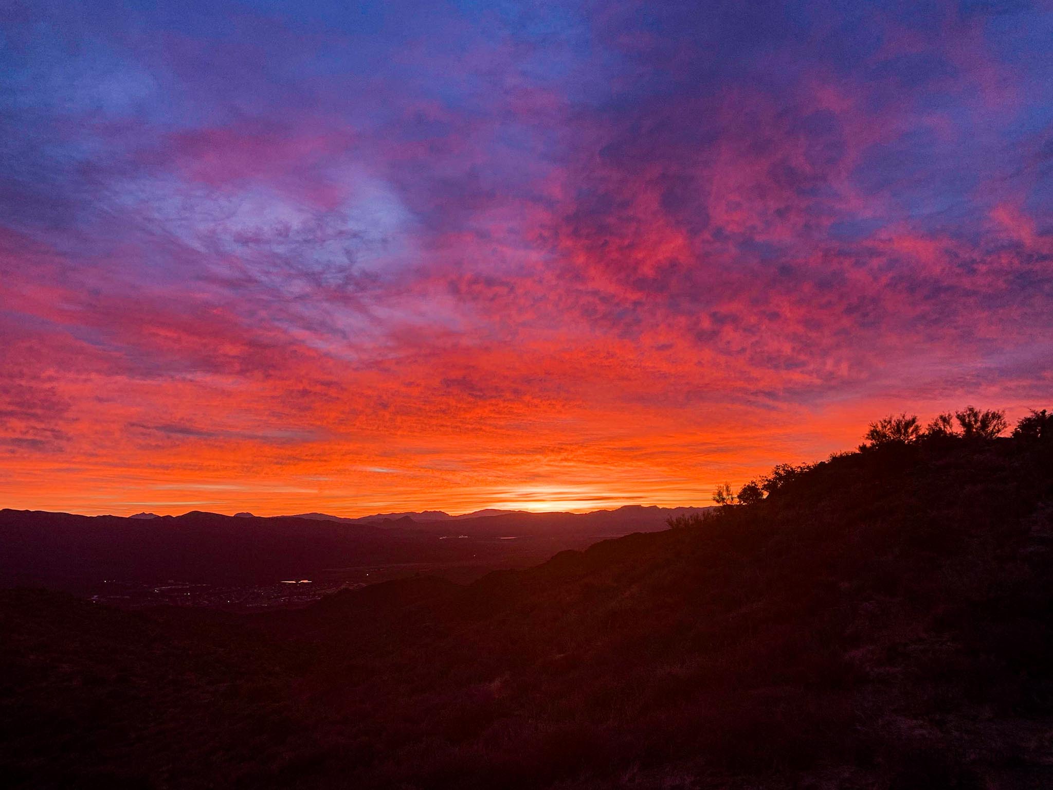
The sunrise this morning was incredible. I head over to watch it from the overlook of Kearny near where I camped last night. Red, magenta, maroon, orange…just about every color one could imagine being a part of sunrise joined the party. After taking it in and climbing to the top of The Big Hill, I see the first other trail user I’ve seen since Picketpost. He’s a biker heading to Flag. We talk a bit and exchange intel on the upcoming segments of the trail.

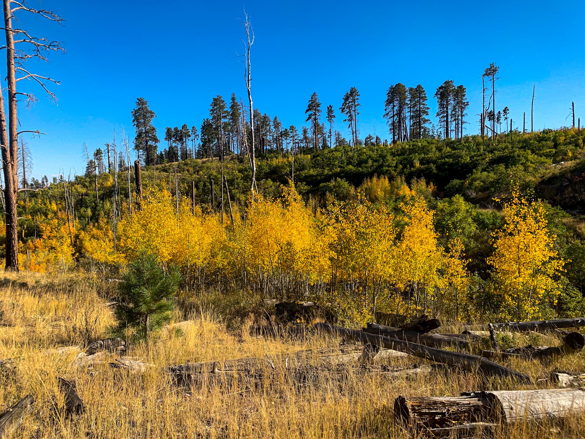
Arizona Trail, Passage 15: Tortilla Mountains


Arizona Trail, Passage 15: Tortilla Mountains

Arizona Trail, Passage 15: Tortilla Mountains

Arizona Trail, Passage 15: Tortilla Mountains

Arizona Trail, Passage 15: Tortilla Mountains

Arizona Trail, Passage 15: Tortilla Mountains


Arizona Trail, Passage 15: Tortilla Mountains

Arizona Trail, Passage 15: Tortilla Mountains

Arizona Trail, Passage 15: Tortilla Mountains

Arizona Trail, Passage 15: Tortilla Mountains

Arizona Trail, Passage 15: Tortilla Mountains

Arizona Trail, Passage 15: Tortilla Mountains

Arizona Trail, Passage 15: Tortilla Mountains

Arizona Trail, Passage 15: Tortilla Mountains
Arizona Trail: The Big Hill-Camp
Descending from the summit of the Big Hill, the trail arrives at Ripsey Wash and its “forest of swollen saguaros,” as described by the Arizona Trail Association in their guidebook. Some of the saguaros have arms that curve in various directions, dipping down and then curving back up (or just dipping down to date). Apparently, this is due to freezes and colder periods in desert winters. Crossing Ripsey, the AZT passes through drainages and gates and follows some power lines until a couple miles before Florence Rd. The sunset isn’t as spectacular as other nights, but an orange underlighting glow spreads under the clouds to the west and south, silhouetting the Sky Islands in the distance.


Arizona Trail, Passage 15: Tortilla Mountains

Arizona Trail, Passage 15: Tortilla Mountains

Arizona Trail, Passage 15: Tortilla Mountains


Arizona Trail, Passage 15: Tortilla Mountains


Arizona Trail, Passage 15: Tortilla Mountains

Arizona Trail, Passage 15: Tortilla Mountains

Arizona Trail, Passage 15: Tortilla Mountains


Arizona Trail, Passage 15: Tortilla Mountains

Arizona Trail, Passage 15: Tortilla Mountains

Arizona Trail, Passage 15: Tortilla Mountains

Arizona Trail, Passage 15: Tortilla Mountains


Arizona Trail, Passage 15: Tortilla Mountains

Arizona Trail, Passage 15: Tortilla Mountains

Arizona Trail, Passage 15: Tortilla Mountains

Arizona Trail, Passage 15: Tortilla Mountains


Arizona Trail, Passage 15: Tortilla Mountains

Arizona Trail, Passage 15: Tortilla Mountains

Arizona Trail, Passage 15: Tortilla Mountains

Arizona Trail, Passage 15: Tortilla Mountains

Arizona Trail, Passage 15: Tortilla Mountains


Arizona Trail, Passage 15: Tortilla Mountains
Now dark, the lights of Phoenix to the north and what I presume to potentially be Tucson to the south (maybe Oracle) are clearly visible. Phoenix again seems to have a cloud sitting over it that the light is illuminating, like last night. My first camp is a little breezy for my liking, so I backtrack a bit for some more shelter (only having my shell with me for this leg) and potentially my last night cowboy camping for a while given the weather that seems to be coming in the next few days.

Arizona Trail, Passage 15: Tortilla Mountains


Arizona Trail, Passage 15: Tortilla Mountains

Arizona Trail, Passage 15: Tortilla Mountains


Arizona Trail, Passage 15: Tortilla Mountains

Arizona Trail, Passage 15: Tortilla Mountains

Arizona Trail, Passage 15: Tortilla Mountains
Passage 15 Logistics
| Passage 15 (Tortilla Mountains) | |
| AZTA Page and Map | Passage 15 (Tortilla Mountains) Passage 15 Map Passage 15 Elevation Profile |
| Weather | Passage 15 Weather |
| Trail Surface | Dirt Singletrack |
| Length (Mi) | 28.1 |
| Season | September-May |
| Potential Water Sources | Gila River Trailhead (MM 524.5 SOBO/264 NOBO) Florence/Kelvin Rd Trailhead (MM 526.4 SOBO/262.1 NOBO) Florence/Kelvin Rd Resupply Box (MM 526.5 SOBO/262 NOBO) Ripsey Wash (MM 533.9 SOBO/254.5 NOBO) Water (MM 534.9 SOBO/254.6 NOBO) Water Tank (MM 535.3 SOBO/253.2 NOBO) Tank (MM 538.7 SOBO/249.8 NOBO) Wildlife Tank (MM 540.3 SOBO/248.2 NOBO) Ripsey Ranch Water Trough (MM 541.8 SOBO/246.7 NOBO) Stock Tank (MM 545.3/243.2 NOBO) Freeman Rd Resupply Box (MM 551.8 SOBO/236.7 NOBO) Full sources & Current Status: Arizona Trail Water Sources |
| Trailheads | North: Kelvin-Riverside Trailhead South: Freeman Road Trailhead |
| Trailhead Access | North: Vehicular access; via paved road South: Vehicular access via dirt road |
| Wilderness | No |
| Possible resupply points | Kearny (preferred, requires hitch or roadwalk) Hayden Winkelman |
| ATA-Rated Difficulty | Moderate |
| Potential campsites | Terrain is pretty dry and rugged. Lots of cacti. Beautiful campsite overlooking Kearny near summit of the Big Hill, and at Kelvin-Riverside trailhead toward the north end of the passage. |
| Ecosystems Traversed | Arizona Upland, mostly |
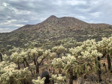
| Highlights | Rugged canyon scenery Ripsey Wash & saguaro forest The Big Hill & views from summit Views of Sky Islands to south on southern stretches Views of Superstitions, Four Peaks & Gila River Canyons to north on northern stretches Desert flora & fauna diversity Solitude |
| Dog friendly? | Yes |
| Bike friendly? | Yes |
| Hazards | One of the drier and more remote passages on trail. Extreme Heat in summer Flash flooding during monsoon (July-September) |
Passage 15 Ecology
| Arizona Upland | |
| Common Trees/Shrubs | * Fairy duster * Blue and littleleaf palo verde * Fremont wolfberry * Graythorn * Ocotillo * Red barberry * Scrub-live oak * Snapdragon-penstemon * Turpentine bush * Velvet mesquite * Whitethron acacia |
| Common herbaceous plants | * California flannelbush [rare in Arizona, Superstition Mountains included] * Bluedicks * Brittlebush * California poppies * Creamcups * Desert chicory * Desert rockpea * Desert windflower * Fringed red maids * Globemallows * Lupines * Sego-lily |
| Common succulents | * Arizona pencil cholla * Banana yucca * Soaptree yucca * Buckhorn cholla * Cane cholla * Chainfruit * Hedgehog cactus * Pencil cholla * Pincushion cactus * Prickly pears * Saguaro * Teddybear cholla |