AZT Passage 14: Black Hills
Arizona Trail Day 70, Part 2
Trans-Arizona/Utah Day 78, Part 2
Welcome back to Aspen’s Tracks, thruhiking the Arizona Trail southbound from Utah to Mexico. Today’s entry covers backpacking the northern stretch of Passage 14, the Black Hills, between the northern AZT passage boundary at Freeman Road trailhead to my camp for the night about halfway through the passage. You can find today’s hiking logistics below the photo documentation and trail journal of the route.
If you missed my last entry covering the leg through the southern segment of the Tortilla Mountains, that can be found here. The next entry will cover the southward toward the Tiger Mine Trailhead near Oracle.
(Note: the photos herein are smaller and at 50% quality, however, full quality ones are available to those interested, please contact me separately if so. This change was made to speed page loading but if you would prefer the full quality images please leave a comment to let me know).
In the land of Arizona
“The Arizona Trail,” Dale R Shewalter
Through desert heat or snow
Winds a trail for folks to follow
From Utah to Old Mexico
It’s the Arizona Trail
A pathway through the great Southwest
A diverse track through wood and stone
Your spirit it will test
Some will push and pedal
And some will hike or run
Others will ride their horse or mule
What else could be more fun?
Oh, sure you’ll sweat and blister
You’ll feel the miles each day
You’ll shiver at the loneliness
Your feet and seat will pay
But you’ll see moonlight on the borderlands
You’ll see stars on the Mogollon
You’ll feel the warmth of winter sun
And be thrilled straight through to bone
The aches and pains will fade away
You’ll feel renewed and whole
You’ll never be the same again
With Arizona in your soul
Along the Arizona Trail
A reverence and peace you’ll know
Through deserts, canyons, and mountains
From Utah to Old Mexico
Arizona Trail: Freeman Road-Antelope Peak South
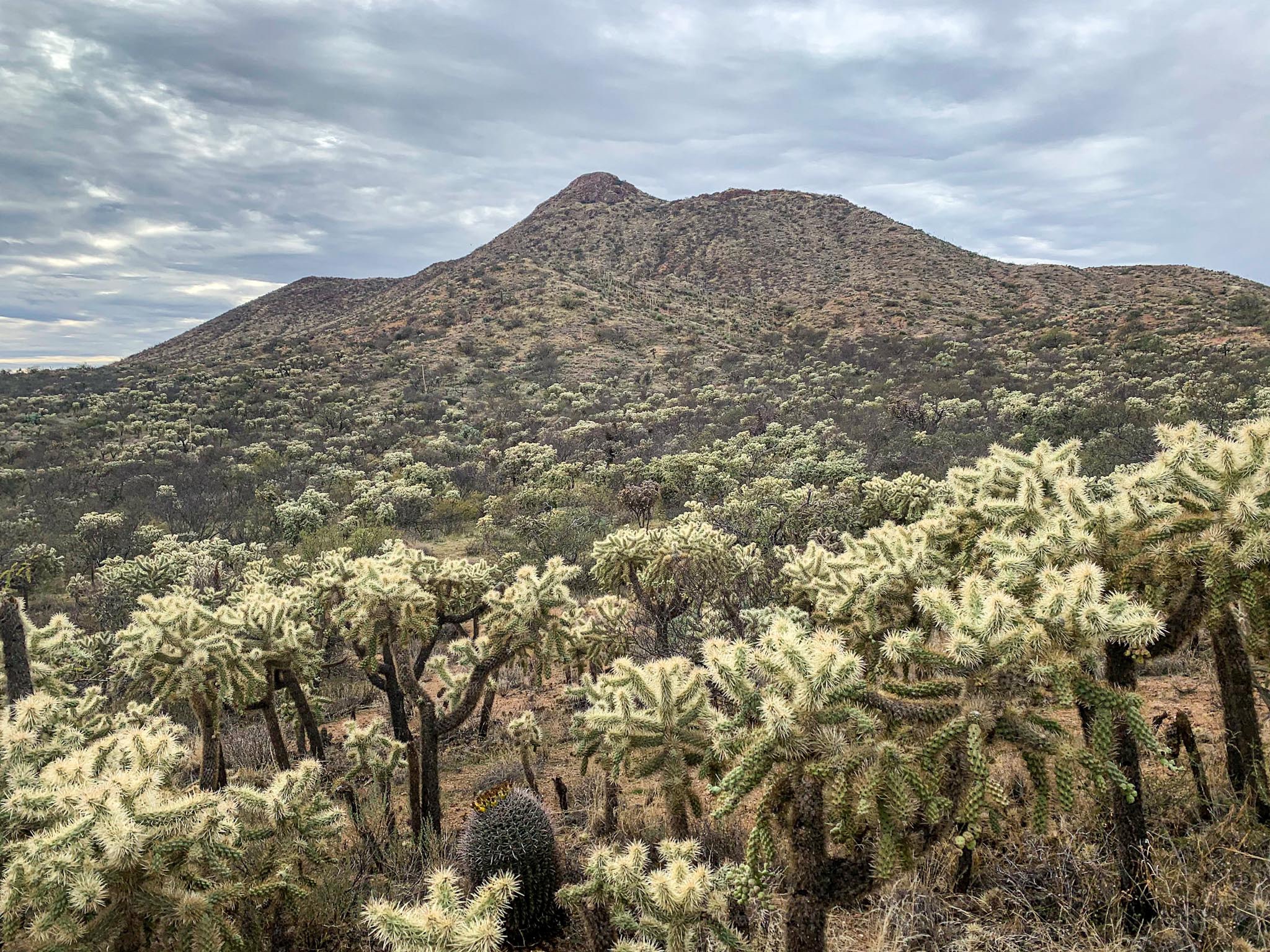
Around midday, I arrive at the Freeman Road trailhead, and the passage boundary between the Tortilla Mountains and Black Hills. Heading south, the trail winds around Antelope Peak, a pretty solitary and prominent peak west of the Gila and south of Freeman Road. Other than the traverse around the peak, the terrain on the first 3-4 miles is pretty flat.


There are some nice glimpses to the east to the mountains across the Gila River Valley, and there are some nice patches of sunlight that shine on them heading south from the trailhead. The arid conditions continue, though. It looks like peds (soil clumping that forms under drought conditions) are starting to form. There’s also virtually no shade, so I’d hate to be here during the hotter times of the year. The trail also begins to pass through some of the densest forests of chollas that I’ve ever seen, many of which appear to be fruiting.

Arizona Trail, Passage 14: Black Hills

Arizona Trail, Passage 14: Black Hills

Arizona Trail, Passage 14: Black Hills

Arizona Trail, Passage 14: Black Hills

Arizona Trail, Passage 14: Black Hills

Arizona Trail, Passage 14: Black Hills

Arizona Trail, Passage 14: Black Hills


Arizona Trail, Passage 14: Black Hills
Arizona Trail: Antelope Peak South-Camp Grant Wash North Rim
As the trail continues south, it begins to roll a bit more but generally trends downhill toward the Camp Grant Wash that occurs roughly at the passage midpoint. During some of the upswings, though, some nice views can be seen to the east across the Gila River Valley, and to the south, toward the Sky Islands, notably the Santa Catalinas but also the Rincons and [ADD HERE] farther south as well.
The trail then roughly begins to descend toward Camp Grant, but I call it a night before reaching that point, since there’s a resupply box there and it doesn’t look like any weather will move in before I attempt to cross that area. So being able to stop in there and stock up before continuing down toward Oracle will work nicely. Nice sunset view again tonight from my campsite before the trail descends down to Camp Grant, although the clouds are a bit more underlit than they have been in the past.


Arizona Trail, Passage 14: Black Hills

Arizona Trail, Passage 14: Black Hills

Arizona Trail, Passage 14: Black Hills


Arizona Trail, Passage 14: Black Hills


Arizona Trail, Passage 14: Black Hills

Arizona Trail (Passage 14): Black Hills

Arizona Trail, Passage 14: Black Hills

Arizona Trail, Passage 14: Black Hills
Passage 14 Logistics
| Passage 16 (Gila River Canyons) | |
| AZTA Page and Map | Passage 16 (Gila River Canyons) Passage 16 Map Passage 16 Elevation Profile |
| Weather | Passage 16 Weather |
| Trail Surface | Dirt Singletrack |
| Length (Mi) | 25.7 |
| Season | September-May |
| Potential Water Sources | Gila River is unreliable and must be prefiltered and/or settled when flowing. Walnut Canyon may have water. Full sources & Current Status: Arizona Trail Water Sources |
| Trailheads | North: Tonto National Forest boundary South: Kelvin-Riverside Bridge |
| Trailhead Access | North: No vehicular access South: Vehicular access via paved road |
| Wilderness | No |
| Possible resupply points | Superior (north end) Kearny (south end, requires roadwalk or hitch) |
| ATA-Rated Difficulty | Difficult |
| Potential campsites | Terrain is pretty dry and rugged, but there are numerous campsites along the section paralleling the Gila River. |
| Ecosystems Traversed | Arizona Upland, mostly Riparian along the Gila River |
| Highlights | Rugged canyon scenery Gila River Walnut Canyon Wildlife |
| Dog friendly? | Yes |
| Bike friendly? | Yes |
| Hazards | One of driest passage on trail. Gila River is unreliable and must be prefiltered and/or settled when flowing. Walnut Canyon may have water. Extreme Heat in summer Flash flooding during monsoon (July-September) |
Passage 14 Ecology
| Arizona Upland | |
| Common Trees/Shrubs | * Fairy duster * Blue and littleleaf palo verde * Fremont wolfberry * Graythorn * Ocotillo * Red barberry * Scrub-live oak * Snapdragon-penstemon * Turpentine bush * Velvet mesquite * Whitethron acacia |
| Common herbaceous plants | * California flannelbush [rare in Arizona, Superstition Mountains included] * Bluedicks * Brittlebush * California poppies * Creamcups * Desert chicory * Desert rockpea * Desert windflower * Fringed red maids * Globemallows * Lupines * Sego-lily |
| Common succulents | * Arizona pencil cholla * Banana yucca * Soaptree yucca * Buckhorn cholla * Cane cholla * Chainfruit * Hedgehog cactus * Pencil cholla * Pincushion cactus * Prickly pears * Saguaro * Teddybear cholla |
נערות ליווי בחולון
I was excited to find this website. I want to to thank you for your time just for this wonderful read!! I definitely really liked every part of it and I have you saved to fav to look at new things in your blog.