Glen Canyon National Recreation Area
Lee’s Ferry & the Colorado River
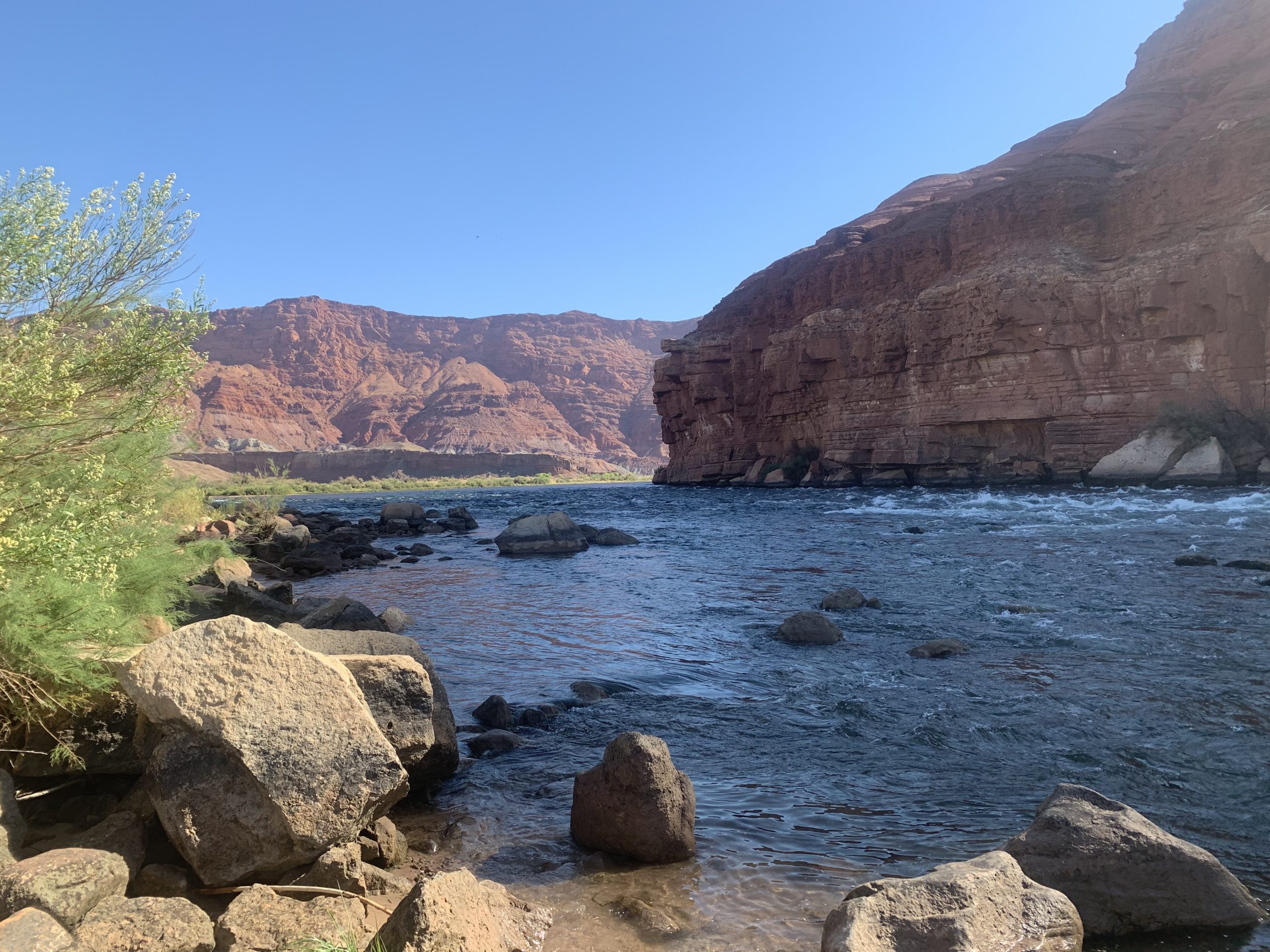
It’s a gorgeous sunny day in Northern Arizona, although still pretty hot with a hot in the mid/upper 90s. I packed up this morning to start backpacking into the Paria Canyon-Vermilion Cliffs Wilderness. First, though, I took a brief wander down to the Colorado River beach to see how the river looked and hunt for a sign that Steve, a national park traveler friend who stopped by the Canyon and who I’d advised to stop by Lee’s Ferry had told me about. It marks the northern border of Grand Canyon National Park. Hiking alone the beach for a bit, I found it, on the beach where river trips launch to raft down the Colorado through the canyon.

Glen Canyon National Recreation Area
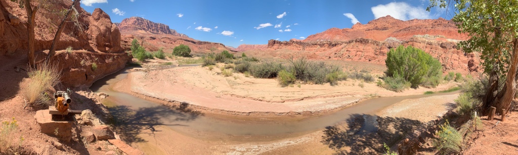
The last time I was here, the Paría River was flowing much stronger and you could see the two rivers flow side by side between the beach and the Navajo Bridge. But given how dry it has been recently that was not the case today, just the blue Colorado water. Seeing that deep blue water against the red cliffs of Marble Canyon is always beautiful, but it also breaks my heart a bit, because the river should be a muddy brown with sediment.
In fact, literally the name Colorado River means “colored river” or “red river” in Spanish, and received that name due to the color in it from the sediment it carries. But Glen Canyon Dam now traps all that sediment, so it only turns its natural color after rains. The river now also runs about 40-50 degrees rather than its natural 85.
Feel free to ask if you have more questions about the river, one of my favorite features of the Southwest and one I could write about in depth. What features do you have that you connect to where you live?

Glen Canyon National Recreation Area

Glen Canyon National Recreation Area
Glen Canyon National Recreation Area: Lonely Dell Ranch
I then headed over to Lonely Dell Ranch at the mouth of Paría Canyon and enjoyed a ranger program there about the prior occupants of the ranch including John D. Lee, the namesake of Lee’s Ferry and someone perhaps best known for his role in the Mountain Meadows Massacre, for which he was executed in 1877. The orchards at the ranch also have free fruit to pick, and I enjoyed some fresh pears before heading up Paría Canyon.

Glen Canyon National Recreation Area

Glen Canyon National Recreation Area


Paria Canyon (Vermilion Cliffs National Monument)
The Canyon was pretty wide today, but I’m not expecting that to remain the case moving forward. I have two weeks of supplies on me to get back to the South Rim. It’s also 15 miles to the first source of water at the top of the Chinle Formation, so I’m pretty loaded down with water today given that and the heat, can’t wait to drink down some of that weight and start eating my way through my pack.
There’s a trail from Lee’s Ferry through the portion of Paría Canyon that is within Glen Canyon NRA, but after crossing the border into the Paría Canyon-Vermilion Cliffs Wilderness the river is the trail. I’m essentially doing the lower portion of the Hayduke Trail to get to the start of the Arizona Trail, and the landscape soon proves diverse and stunning, with old historic features at first, followed by spectacular colors and light in the canyon.
(Please note that a permit is required from the US Bureau of Land Management for all overnight stays in the Paría Canyon-Vermillion Cliffs Wilderness. Permits are limited to 20 people/night and can be reserved online. Adequate preparation is essential before undertaking a trip through a wilderness area; one must be prepared to be self sufficient and away from all services and assistance. If you are interested, let me know and I can help and provide you with more information on the matter.)

Glen Canyon National Recreation Area

Glen Canyon National Recreation Area

Glen Canyon National Recreation Area


Glen Canyon National Recreation Area
Lee’s Ferry Into Paria Canyon

Glen Canyon National Recreation Area

Glen Canyon National Recreation Area


Paria Canyon-Vermilion Cliffs Wilderness
Vermilion Cliffs National Monument

Paria Canyon-Vermilion Cliffs Wilderness
Vermilion Cliffs National Monument

Paria Canyon-Vermilion Cliffs Wilderness
Vermilion Cliffs National Monument

Paria Canyon-Vermilion Cliffs Wilderness
Vermilion Cliffs National Monument

Paria Canyon-Vermilion Cliffs Wilderness
Vermilion Cliffs National Monument

Paria Canyon-Vermilion Cliffs Wilderness
Vermilion Cliffs National Monument

Paria Canyon-Vermilion Cliffs Wilderness
Vermilion Cliffs National Monument

Paria Canyon-Vermilion Cliffs Wilderness
Vermilion Cliffs National Monument

Paria Canyon-Vermilion Cliffs Wilderness
Vermilion Cliffs National Monument

Paria Canyon-Vermilion Cliffs Wilderness
Vermilion Cliffs National Monument
Trail Logistics for Paria Canyon-Vermilion Cliffs Wilderness
Paria Canyon-Vermilion Cliffs Wilderness Logistics
| Paria Canyon-Vermilion Cliffs Wilderness | |
| BLM Information | Paria Canyon-Vermilion Cliffs Wilderness |
| Weather Forecast | Buckskin Gulch Weather |
| Trail Surface | Rustic (the river is the trail) |
| Length (Mi) | 45 (Lee’s Ferry to Wire Pass via Buckskin Gulch) 38 (Paria Canyon, Lee’s Ferry to White House) 20 (Wire Pass to White House via Buckskin Gulch) 22, approx. (Buckskin Gulch to White House) 1.8 (Wire Pass to Buckskin Gulch) |
| Season | Fall-Spring. Brutally hot in summer. |
| Potential Water Sources | Springs. Unless informed otherwise by a BLM ranger, there is likely no drinkable water in Buckskin Gulch, and the Paria River should be considered undrinkable even when filtered. Know how to recognize desert springs. |
| Trailheads | Paria Canyon North: White House Paria Canyon South: Lee’s Ferry Buckskin Gulch Middle Exit Buckskin Gulch West Wire Pass |
| Trailhead Access | Vehicular access to all trailheads |
| Wilderness | Yes |
| Possible resupply points | None |
| Difficulty | Strenuous |
| Potential campsites | Best near springs. Some higher-water campsites in north, south of Buckskin Gulch-Paria Canyon confluence. Use higher water sites if there is any risk of rain. Few to no campsites in Buckskin Gulch. |
| Threats | Flash flooding – Extreme hazard here. Know the forecast daily (an inReach or other satellite communicator helps with this). Know how to recognize the signs of a flash flood and how to react. You cannot outrun a flash flood; you must climb above it. This is not possible in Buckskin Gulch – do not enter it if storms are in the forecast during your trip. Heat – wear a cotton shirt so you can soak it. Synthetics aren’t great in the desert. Hyponatremia – “drunk on water.” To avoid, ensure adequate salt & electrolyte intake and ensure you eat as well as drink water. Symptoms are almost identical to dehydration, but drinking more makes it worse. Prevention is by far the best solution. Dehydration Hypothermia in winter, made worse by exposure to cold water Because there is no trail, there are places where boulders must be climbed around or over and at least one spot where your pack must be hauled over a boulder jab. Flash floods change the trail, shifting obstacles around, removing some and adding others. Expect the unexpected. |
| Permits Required? | Yes. 20 people max per night issued on recreation.gov . |
| Miscellaneous | Leave No Trace is different in the desert. Know desert principles and carry wag bags. |
| Cell service? | Nonexistent |
One thought on “Backpacking Amazing Vermilion Cliffs – Lee’s Ferry & Beautiful Lower Paria”